

25 years after Minnesota tornado outbreak, severe weather forecasting has advanced greatly
Go Deeper.
Create an account or log in to save stories.
Like this?
Thanks for liking this story! We have added it to a list of your favorite stories.
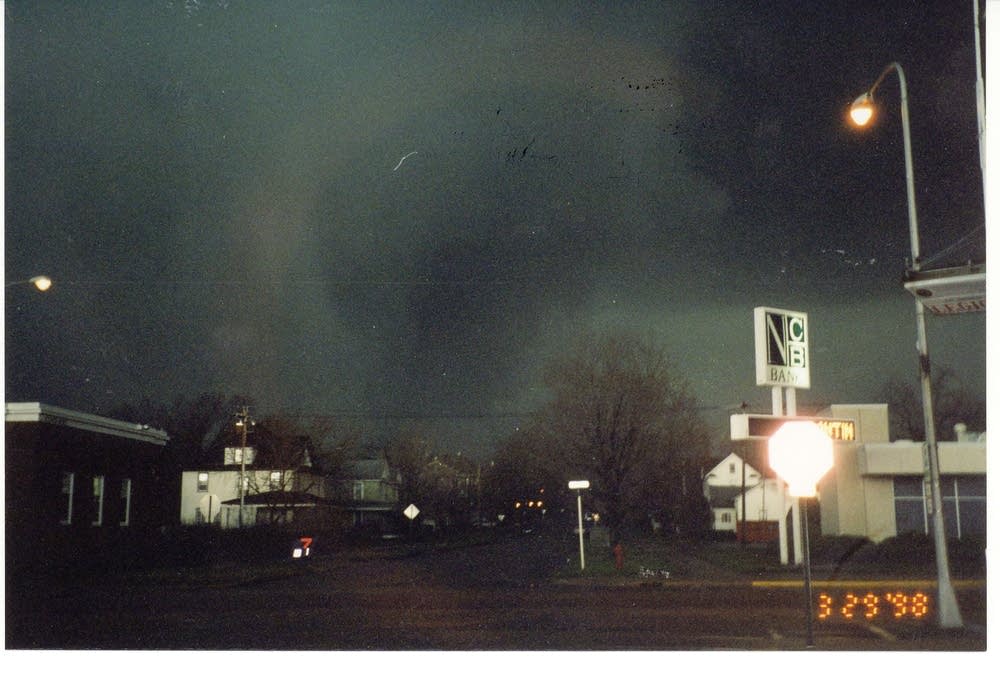
Wednesday marks 25 years since tornadoes ripped across southern Minnesota, killing two people and destroying homes and businesses on March 29, 1998.
More than a dozen tornadoes swept through the region, with major damage in Comfrey and the Lake Hanska area. In St. Peter, Minn., an F3 tornado destroyed more than 200 homes and flattened schools and businesses.
Since then, forecasting severe weather has advanced significantly, especially with improved radar capabilities which detect a storm’s speed and location.
Jacob Beitlich, a meteorologist with the National Weather Service's Twin Cities forecast office, said that while there are similarities in how storms are detected now compared to 25 years ago, today’s radar technology makes a significant difference.
Turn Up Your Support
MPR News helps you turn down the noise and build shared understanding. Turn up your support for this public resource and keep trusted journalism accessible to all.
“We used to get scans that were very coarse resolution every five, six or even seven minutes. And now we can get high-resolution radar images on the order of, say, 45 to 60 seconds,” Beitlich said.
Beitlich said that in order to monitor storms in real time, meteorologists use a Doppler radar, which senses the motion and rotation within a storm. But he said the Doppler radar used 25 years ago was far less advanced than radar systems today.

“Think of your first video game systems, and the graphics are pretty bad. I think of video systems today as much better. So back in 2008, we got our super resolution radar. And that just allowed us to see a lot more detail in the atmosphere than we could before then,” he said.
But while meteorology relies heavily on technology, Beitlich said storm spotters are still just as necessary as they were 25 years ago.
“When we’re toward the edges of our forecast area, a radar coverage isn’t as good as when we’re closer to our radar. So we rely on storm spotters to put eyes on the storms and tell us what’s going on where they’re at,” Beitlich said.
The Weather Service’s Twin Cities office offers storm spotter training sessions each spring. So do the forecast offices in La Crosse, Wisc.; Duluth; Sioux Falls, S.D.; and Grand Forks, N.D.
The terminology used to classify the strength of tornadoes is also different today, compared to back in 1998.
It used to be the Fujita Scale, estimating wind speeds in a tornado based on the damage it left behind. Beitlich said a group of scientists and engineers modified the original scale to what’s now the Enhanced Fujita (EF) Scale.
“It’s just some of the numbers vary a little bit, as to what the range is between the different thresholds,” he said — but the general premise remains the same.
Beyond technology, Beitlich said some of the biggest advancements in meteorology have been debunking myths, like the idea that a tornado can’t go through a big city — something disproven by the tornado that cut a swath of damage across north Minneapolis in 2011, among others.
Or the idea that a tornado can’t cross a river; Beitlich said there have been well-documented cases of strong tornadoes that have gone through valleys.
“We’re just, you know, observing a lot more, which means we have more to understand,” he said. “But we still have a long ways to go.”
According to the State Climatology Office, more than 2,000 tornadoes touched down in Minnesota between 1950 and 2020.
Find more weather information and forecast updates on MPR Weather’s Updraft blog.