

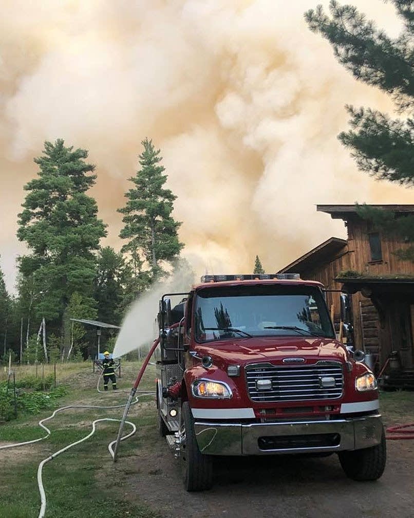
Greenwood Fire grows to more than 9,000 acres, forces more evacuations in NE Minnesota
Go Deeper.
Create an account or log in to save stories.
Like this?
Thanks for liking this story! We have added it to a list of your favorite stories.
Updated: Aug. 21, 7:55 a.m.
The Greenwood Fire in northeastern Minnesota grew to more than 9,000 acres early Saturday — up from fewer than 5,000 acres Friday morning — as firefighting crews prepared for gusty, erratic winds from a cold front moving across the region.

The fire — zero percent contained at last report — prompted another round of evacuations Friday afternoon after it jumped a county highway and spread to the west.
In an update Saturday morning, fire officials said they continued to see “extreme wind-driven runs” of the flames.
And National Weather Service meteorologist Ketzel Levens said Saturday morning that while parts of Minnesota saw heavy rain Friday and overnight, the storms diminished as they moved east.
Turn Up Your Support
MPR News helps you turn down the noise and build shared understanding. Turn up your support for this public resource and keep trusted journalism accessible to all.
"They lost a lot of the intensity that ... we were observing in western and central Minnesota. So around the Greenwood Lake fire, the maximum rainfall that I've seen there is only a tenth of an inch,” Levens said.
The Superior National Forest reported Friday that the fire spread west across County Highway 2 just north of Stony Lake, about 40 miles north of Two Harbors.
The Forest Service said that was a "management action point," and triggered evacuations in the Sand Lake and Stony Lake areas. Officials said additional evacuations also were underway to the northwest along State Highway 1, near Slate, West Chub, East Chub and Highlife lakes about 20 miles southeast of Ely.
The spread of the fire across Highway 2 was something "we were concerned about over the last day or so and kind of anticipated that it could do, if the winds were to pick up and continue shifting in the right direction, which they are," Superior National Forest public information officer Joanna Gilkeson told MPR News as the news broke Friday. "The winds seem to be a little bit stronger today. ... Fire crews and aircraft are engaged in suppressing the fire right along Highway 2. And we do have structure protection crews in place to help defend those structures."
Gilkeson said Lake County residents who had signed up for emergency alerts should get a notification on their phone if they're in an area being evacuated. The Lake County Sheriff's Office is also out notifying people in-person.
Friday's additional evacuations are on top of dozens of homes and cabins evacuated earlier in the week, many around the McDougal chain of lakes.
More than 290 firefighters are now working to contain the lightning-caused Greenwood Fire, aided by several water-dropping aircraft.
Beyond the immediate concerns about the fire's spread on Friday, crews also are bracing for the arrival of a cold front this weekend that'll bring gusty winds shifting from the south to the northwest.
Pete Glover, operations section chief with the Eastern Area Type 2 Incident Management Gold Team which is managing the fire, said during an online briefing Friday afternoon that the wind is "really the driving force of what pushes the fire. It's the steering wheel and the gas pedal of the fire. So we're coming up with plans of how to deal with that. We're setting trigger points of when to move our crews back if the winds get too gusty, and the fire behavior picks up rapidly. But we're still looking for opportunities where we can contain the fire.
Glover said those opportunities can be both natural features such as lakes and rivers, or manmade fire breaks.
Expanded BWCA closure
As crews battled the Greenwood Fire on Friday, the Forest Service also announced an expanded closure of the Boundary Waters Canoe Area Wilderness due to the Whelp Fire burning about 4 miles northwest of Sawbill Lake. The lightning-caused fire is estimated at 25 to 30 acres in size and is "an actively moving surface fire with open flames visible. No firefighting crews have been sent in due to difficult access, limited aircraft resources, and safety concerns," the Forest Service reported. Aircraft are dropping water on the fire.
The expanded closure area includes Alton Lake and the "Lady Chain" of lakes west of Sawbill. All overnight permits out of the Sawbill entry point for at least the next three days are canceled and will be refunded, though day-use paddling is still allowed from that entry point to the north and east of Sawbill Lake.
Wilderness ranger crews are paddling the closure area to notify campers.
Lakes and rivers in the Whelp Fire closure area include Alton Lake, Sunhigh Lake, Wonder Lake, Beth Lake, Ella Lake, Grace Lake, Phoebe Lake, Knight Lake, Hazel Lake, the Phoebe River, Hub Lake, Mesaba Lake, Dent Lake, Chaser Lake, Bug Lake, Louse Lake, Louse River, Poe Lake, Mug Lake, Wine Lake, Frederick Lake, Hug Lake, Duck Lake, Zenith Lake, Trail Lake, Boze Lake, Frond Lake and Lujenida Lake.
A closure order also remains in effect for much of the western BWCA, north and northwest of Ely, due to the threat of wildfires in Ontario's Quetico Provincial Park spreading south across the border. That order has been in place for more than a month.