Pretty nice weekend ahead; 80 degrees and a severe storm risk possible Monday
Typical late-April weekend ahead; strong to severe storms possible Monday

Go Deeper.
Create an account or log in to save stories.
Like this?
Thanks for liking this story! We have added it to a list of your favorite stories.
It’s been a real spring in Minnesota this year.
This has been one of those rare Aprils where temperatures climbed gradually. The month brought us close to normal temperatures. We didn’t vault from snow to 80 degrees in a few days this April as has happened in the recent past.
So this year we enjoy one last typical April weekend around Minnesota. The normal high and low for the Twin Cities Saturday are 62 and 42 degrees. We’re going to be pretty close to normal for this last weekend of April.
More beneficial rainfall
Parts of southern Minnesota soaked in more beneficial rainfall Thursday into early Friday. This time it was areas in southwestern Minnesota that are still abnormally dry to moderate drought. The heaviest rain fell in areas southwest of Mankato.
Turn Up Your Support
MPR News helps you turn down the noise and build shared understanding. Turn up your support for this public resource and keep trusted journalism accessible to all.
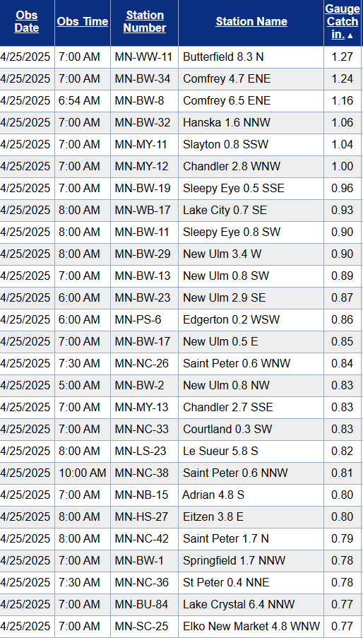
Much of southern Minnesota picked up one-half inch to more than 1 inch of rainfall. The Twin Cities areas recorded between about one-third to one-half inch.
Here are the top rainfall totals from our latest system. You can check rainfall in your location here.

Nice weekend
Saturday brings bright late April sunshine, light winds, and near-normal temperatures. The sun angle and intensity now is equivalent to around Aug. 15, so think about using sunscreen on the coolish spring days.

Sunday will be cloudier and breezy. There’s a slight chance for a passing shower Sunday with highs again mainly in the 60s.
Severe risk Monday
I’m still watching for a severe weather risk across much of Minnesota Monday. Several ingredients are coming together to create the risk zone.
First, the warmth. Monday will be the warmest day of the year so far for many Minnesota locations. We’ve topped out at 75 degrees so far in March and April in the Twin Cities. On Monday temperatures will approach 80 degrees from near the Twin Cities southwest.

A potent low-pressure system will spin into Minnesota Monday. The system will advect (horizontally transfer) a plume of dew points in the sticky 60s northward. That moisture will make it feel sticky Monday, and provide fuel for possible severe storms.

There is some question on forecast models as to the extent of storm coverage Monday. There may be some capping (warm air aloft) that may limit storm coverage overall. But any storms that do form may be be severe with damaging winds, large hail, and possible tornadoes.
The National Oceanic and Atmospheric Administration’s Global Forecast System model suggests the potentially spotty nature of storm coverage Monday. The forecast model loop below runs between 7 a.m. Monday and 1 a.m. Tuesday.

The European Centre for Medium-Range Weather Forecasts model shows similar trends with spotty coverage. It suggests a line of severe storms may develop near the Twin Cities Monday afternoon and be farther southeast by 7 p.m. Monday evening.

So, it looks like storm development and coverage will be an hour-by-hour development process Monday. That’s typical on severe weather risk days as micro elements need to come together in the right order to produce severe storms.
NOAA’s Storm Prediction Center lays out a 30 percent risk zone for severe storms across much of southern Minnesota. The highest risk zone favors Iowa Monday.

...DISCUSSION... ...Day 4/Mon - Southern Plains to Upper Midwest... A strong mid-level jet streak will move rapidly northeastward from the Southwest to the Upper Midwest on Monday. As this occurs, a surface low will deepen and move from the northern Plains to the northern Great Lakes. Strong southwesterly lower tropospheric flow will advect high theta-e air northward across the Midwest and into parts of the Upper Midwest. Broken to scattered cloud cover will support surface heating and strong destabilization across the warm sector from southeast Minnesota and western Wisconsin to the southern Plains.
Isolated to scattered supercells are likely along the dryline which will extend from the southern Plains and into Kansas. The greatest focus for severe weather on Monday will be from eastern Kansas into northern Missouri, much of Iowa and into southern Minnesota and western Wisconsin. Moderate to strong instability, strong shear, and increasing forcing for ascent supports the potential for numerous rounds of severe thunderstorms. The wind profile supports supercells capable of all severe weather hazards including the potential for strong tornadoes.
Stay tuned!


