

Cooler-than-normal temperatures and dry for the remainder of the week
Isolated thunder chances possible this weekend

Go Deeper.
Create an account or log in to save stories.
Like this?
Thanks for liking this story! We have added it to a list of your favorite stories.
If you don’t like the heat, it’s been your summer. Cooler-than-normal temperatures will prevail the rest of the week, along with dry conditions and partly cloudy skies.
Pleasant, dry and cooler than normal
High pressure is keeping things mostly clear, dry and cooler than normal through the end of the week.

It’ll be a very nice day Wednesday with afternoon highs mostly in the mid-70s in southern Minnesota to just near 70 north. Those readings are about 5 to 10 degrees cooler than normal. Normal highs range from 78 north to 84 south.

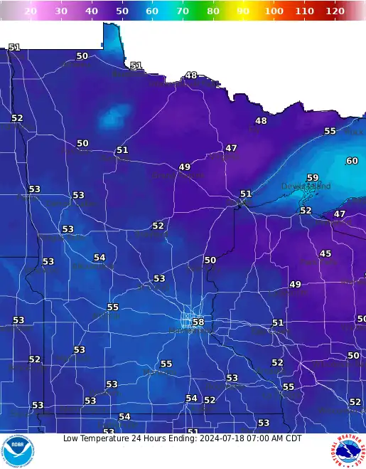
We’ll see plenty of sun with afternoon fair weather cumulus clouds filling in some. Skies will be clear overnight with another cool one. Lows will fall into the 40s north to 50s south.
Turn Up Your Support
MPR News helps you turn down the noise and build shared understanding. Turn up your support for this public resource and keep trusted journalism accessible to all.
Thursday will again be gorgeous with clearer skies and temperatures that will be a few degrees warmer. Most of the state should see highs in the upper 70s.

The rest of the week is much of the same with gradually, slightly warmer temperatures. Highs will be back closer to normal by the weekend mainly in the low 80s. We’ll also see the chance of some isolated thunder in portions of the state by the weekend, especially Sunday.

The six to 10-day temperature outlook calls for higher odds of near or slightly below normal temperatures into early next week.

Most models, however, agree on a warming trend through next week into the end of the month with the odds favoring above-normal temperatures as we end the statistically warmest month of the year.
