

Rain overnight into Tuesday; Minnesota's record wet April-June
Latest models favor rain, thunderstorms late on July Fourth
Go Deeper.
Create an account or log in to save stories.
Like this?
Thanks for liking this story! We have added it to a list of your favorite stories.
Welcome to yet another soggy Minnesota weather record.
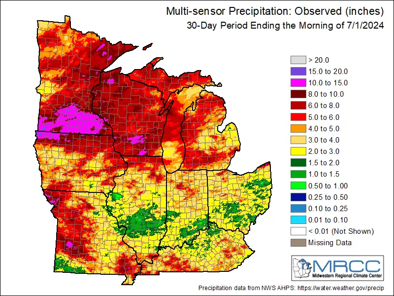
The map above shows June precipitation across the Midwest. Note how much of southern Minnesota received more than 10 inches of rainfall in June!
Climatologist and MPR News contributor Mark Seeley reports:
April through June 2024 was the wettest such period on record for Minnesota, with nearly 16 inches average rainfall across the state.
June was the third-wettest on average across Minnesota.
Faribault in Rice County set a new state record for June rainfall with 17.61 inches.
Next rainfall Monday night into Tuesday
It was a gloriously dry weekend across Minnesota. Now we watch our next wave of rain and thunderstorms roll across Minnesota overnight into early Tuesday.
Turn Up Your Support
MPR News helps you turn down the noise and build shared understanding. Turn up your support for this public resource and keep trusted journalism accessible to all.
The National Oceanic and Atmospheric Administration’s NAM 3 km model shows the trend of rain and thunderstorms sweeping across Minnesota mainly after dark through early Tuesday morning. The forecast model loop below runs between 7 p.m. Monday and 7 a.m. Tuesday.

There is a marginal risk for severe storms Monday evening in southwestern Minnesota, but since storms will arrive after dark the severe potential is minimal.
The heaviest rainfall through Tuesday will occur in Iowa where some multi-inch rainfall totals are likely. Most of Minnesota will pick up between one-quarter and 1 inch of rainfall.

Highs on Tuesday will run in the 70s to lower 80s across Minnesota.

Wednesday looks sunnier and dry with highs in the 80s.

Right now, forecast models favor rain and thunderstorms late in the day on the Fourth of July.
Stay tuned.