

Tornado watch: Severe storms could produce tornadoes across much of Minnesota
Go Deeper.
Create an account or log in to save stories.
Like this?
Thanks for liking this story! We have added it to a list of your favorite stories.
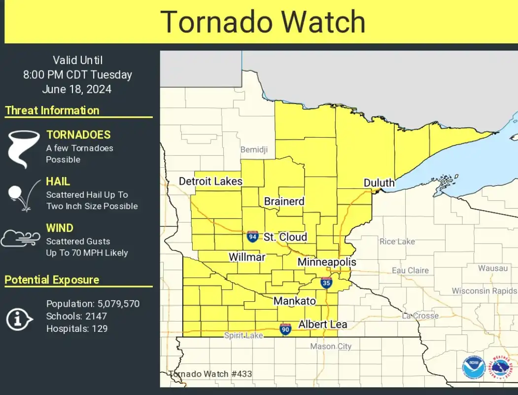
The National Oceanic and Atmospheric Administration’s Storm Prediction Center has issued a tornado watch for much of Minnesota until 8 p.m. Tuesday. A watch means conditions are favorable for the development of tornadoes in and close to the watch area.
Expect strong to severe storms to move east across Minnesota Tuesday afternoon and evening. The most likely window for storms in the greater Twin Cities is between 5 p.m. and 8 p.m.
NOAA’s FV3 model shows the likely progression of the storm line between 4 p.m. and 11:59 p.m. Tuesday:

URGENT - IMMEDIATE BROADCAST REQUESTED Tornado Watch Number 433 NWS Storm Prediction Center Norman OK
125 PM CDT Tue Jun 18 2024 The NWS Storm Prediction Center has issued a
* Tornado Watch for portions of Minnesota
* Effective this Tuesday afternoon and evening from 125 PM until 800 PM CDT.
* Primary threats include... A few tornadoes possible Scattered damaging wind gusts to 70 mph likely Scattered large hail and isolated very large hail events to 2 inches in diameter possible
SUMMARY...Thunderstorms developing along and ahead of a cold front should pose a threat for a few tornadoes, damaging winds up to 60-70 mph, and large hail around 1-2 inches in diameter as they spread east-northeastward this afternoon and early evening. The tornado watch area is approximately along and 65 statute miles east and west of a line from 50 miles northwest of Ely MN to 30 miles east southeast of Worthington MN.
Turn Up Your Support
MPR News helps you turn down the noise and build shared understanding. Turn up your support for this public resource and keep trusted journalism accessible to all.