

A month's worth of rain: 3 to 7 inches in the past week
Heaviest rain may favor northern Minnesota through Tuesday
Go Deeper.
Create an account or log in to save stories.
Like this?
Thanks for liking this story! We have added it to a list of your favorite stories.
Our June monsoon persists this week. A flood watch remains in effect through Tuesday night and into Wednesday for much of Minnesota.

Including the cities of Hutchinson, Victoria, Stillwater, St Paul, Chanhassen, Hastings, Hudson, Minneapolis, Monticello, Olivia, Gaylord, Blaine, Litchfield, Chaska, and Shakopee
253 AM CDT Mon Jun 17 2024
...FLOOD WATCH NOW IN EFFECT THROUGH LATE TUESDAY NIGHT...
* WHAT...Flash flooding caused by excessive rainfall continues to be possible.
* WHERE...Portions of Minnesota, including the following areas, Anoka, Carver, Dakota, Hennepin, McLeod, Meeker, Ramsey, Renville, Scott, Sibley, Washington and Wright and west central Wisconsin, including the following area, St. Croix.
* WHEN...Through late Tuesday night.
* IMPACTS...Excessive runoff may result in flooding of rivers, creeks, streams, and other low-lying and flood-prone locations.
Another round of heavy rainfall soaked much of Minnesota Monday morning. Most of the Twin Cities and southern Minnesota picked up another 1 to 2 inches of rainfall through early Monday morning.
Here are some select rainfall totals as of Monday morning:
Lake Elmo, 2.23 inches
Morgan, 2.12 inches
Glencoe, 1.9 inches
Worthington, 1.6 inches
Owatonna, 1.5 inches
Twin Cities area, 1 to 2 inches

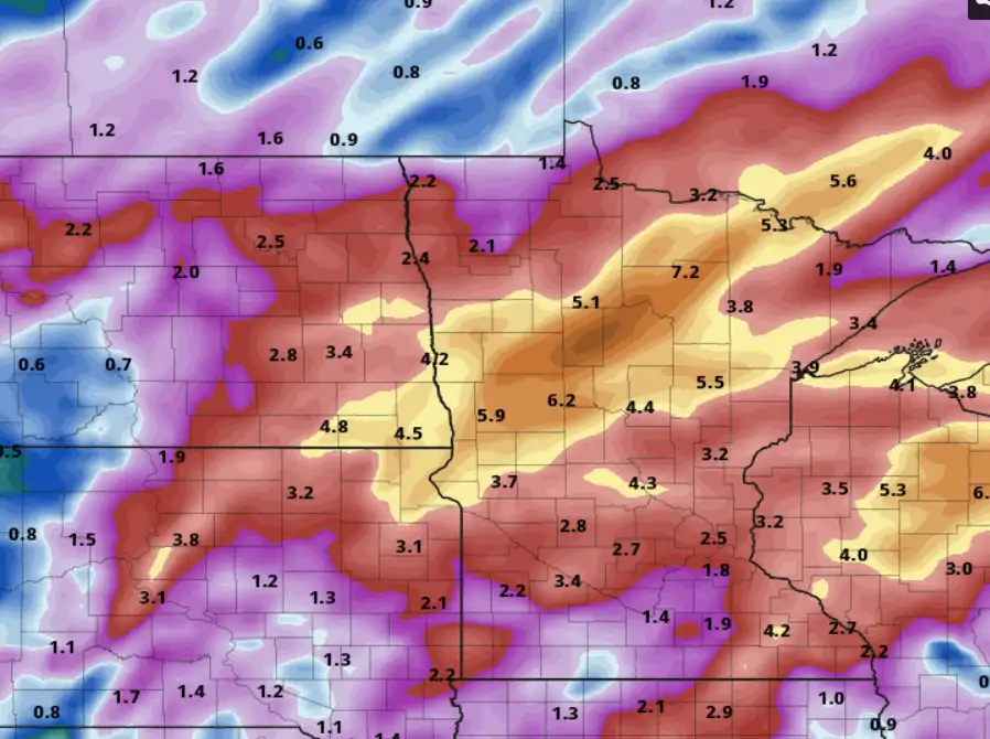
Here’s a more complete listing of rainfall reports through early Monday morning. Additional rainfall occurred at many locations after these reports came in.
Turn Up Your Support
MPR News helps you turn down the noise and build shared understanding. Turn up your support for this public resource and keep trusted journalism accessible to all.
A month’s worth of rain
June is the wettest month of the year on average in Minnesota. The normal June rainfall for the Twin Cities is 4.58 inches. In just the past week much of central and southern Minnesota has picked up more than a month’s worth of summer rainfall.
Glencoe, southwest of the Twin Cities, has recorded 6.97 inches of rain in the past week.
Here are some other incredible rainfall totals for the past seven days.
Twin Cities area, 2 to 5 inches
Bloomington, 4.62 inches
Owatonna, 4.15 inches
New Ulm, 4.68 inches
East Bethel, 5.10 inches
Rainfall patterns through Tuesday favor more rain across the northern half of Minnesota. But another line of storms will likely reach the Twin Cities late Tuesday afternoon and evening.
The National Oceanic and Atmospheric Administration’s High-Resolution Rapid Refresh model shows rainfall trends through Tuesday evening:

We catch a break in the rainfall Wednesday with sunny skies and highs in the 70s.

Another batch of rain arrives Thursday into Saturday, but northern Minnesota may see the heaviest rainfall in the next week.
Right now, next week looks drier overall.
Stay tuned.