

Occasional showers and thunderstorms Friday into the weekend
Significant rainfall totals are likely through Sunday night

Go Deeper.
Create an account or log in to save stories.
Like this?
Thanks for liking this story! We have added it to a list of your favorite stories.
Updated 9 a.m.
The first of two waves of rain and thunder is moving through Minnesota Friday. Another wave of rainfall develops Sunday. There’s a marginal risk of severe weather in far southern Minnesota.
A wet, stormy weekend in store
Showers and thunderstorms are marching across Minnesota Friday into Friday night. Expect occasional scattered areas of rain and some thunderstorms.
We should see a midday break in the Twin Cities before more showers, storms move in late afternoon and evening into the overnight. Most rainfall lifts into primarily northern Minnesota Saturday.

Gusty winds will prevail through Sunday at 15-30 mph. Expect higher gusts in western Minnesota and near Lake Superior.
Support Local News
When breaking news happens, MPR News provides the context you need. Help us meet the significant demands of these newsgathering efforts.
There is a marginal risk (level 1 of 5) of severe storms for far southern Minnesota late Friday into Saturday night. The risk is mainly from severe storms that could hold together moving out of Iowa into southern Minnesota.

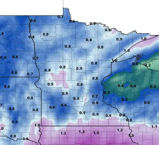
We’ll see a widespread half inch to 1 inch of rainfall with this first round Friday into Saturday.
For those of us that get a mainly dry break Saturday, temperatures will warm into the 60s and even low 70s in southeastern Minnesota. Rain-cooled northern Minnesota will remain in the 40s and 50s.

A second, more significant wave of rainfall develops Sunday into Sunday night.

Saturday into Saturday night could again bring a marginal risk of severe storms for mostly southeastern Minnesota.

Rainfall totals could come in over 2 inches for some areas in central and southern Minnesota and up the North Shore Friday into Monday.
Temperatures next week warm to consistently above-normal levels after Monday.

Next week will then be warmer with highs approaching 70 Tuesday in southern Minnesota.

It’ll still be somewhat active, however, with the next chance of rain, thunder late Tuesday and the again late Wednesday into Thursday.