

60s Monday, snow arrives Tuesday, cold Wednesday
Warm again next weekend
Go Deeper.
Create an account or log in to save stories.
Like this?
Thanks for liking this story! We have added it to a list of your favorite stories.
It sure didn’t feel like winter on Sunday.
The high temperature at Minneapolis-St. Paul International Airport was 51 degrees Sunday afternoon. That’s a typical Twin Cities high temp in early April and it was well above the average Feb. 25 Twin Cities high of 32 degrees.
Parts of south-central and southeastern Minnesota also reached the lower 50s Sunday, with mainly 40s elsewhere in Minnesota. There were a few 30s in northwestern and north-central Minnesota.
Temperatures will be even warmer on Monday.
Support Local News
When breaking news happens, MPR News provides the context you need. Help us meet the significant demands of these newsgathering efforts.
Temperature trends
Monday high temps are expected to reach the 60s across roughly the southern half of Minnesota and also around Moorhead:
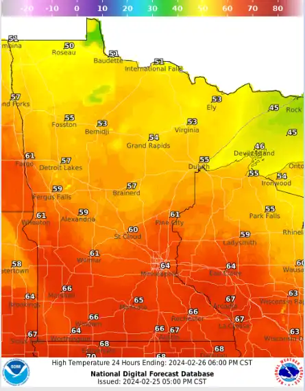
Most of the remainder of Minnesota will see 50s.
Tuesday highs will range from teens in far northwestern Minnesota to lower 50s in the far southeast:

Twin Cities metro area highs will be in the 40s on Tuesday. Much of central and southeastern Minnesota will see falling temps Tuesday afternoon.
Wednesday will feel wintry. Twin Cities metro area highs are projected to reach the mid 20s on Wednesday, followed by lower 40s Thursday then mid 50s on Friday. Metro area highs could be in the 60s next weekend.
Warmer than normal temperatures are expected during the first week of March. Here’s the March 4 through March 10 temperature outlook from the NWS Climate Prediction Center:

Precipitation chances
A brief sprinkle is possible in Minnesota and western Wisconsin Sunday evening. A low pressure system in southern Canada could spin snow showers or a wintry mix over parts of far northern Minnesota late Sunday night and early Monday morning.
You can hear updated weather information for Minnesota and western Wisconsin on the MPR News network.
Snow returns Tuesday
Snow is expected to move into northern Minnesota Tuesday morning, then spread into central and southwestern Minnesota Tuesday afternoon, arriving in the Twin Cities metro area, southeastern Minnesota and western Wisconsin by late Tuesday afternoon or early Tuesday evening.
The metro area might see scattered rain showers at times Tuesday afternoon, before the colder air and the snow arrive later in the afternoon or early Tuesday evening. The snow will initally melt on roads and streets in the metro area and accumulate mainly on grassy areas, but falling temps will eventually lead to slushy accumulations on roads. Much of the metro area could end up with an inch or less of new snow. Some icy spots are possible Tuesday night and early Wednesday.
The National Oceanic and Atmospheric Administration’s North American Mesoscale Forecast System model shows the potential precipitation pattern from 3 a.m. Tuesday to 11 p.m. Tuesday:

Snow amounts of 1 to 2 inches are possible Tuesday into Tuesday night, with some higher amounts in northwestern and north-central Minnesota:

Here’s the snow potential in northeastern Minnesota and northwestern Wisconsin:

A winter storm watch has already been posted for portions of eastern North Dakota and northwestern Minnesota from late Monday night through Tuesday afternoon:

Here are details of the winter storm watch:
URGENT - WINTER WEATHER MESSAGE National Weather Service Grand Forks ND 330 PM CST Sun Feb 25 2024 MNZ001>003-NDZ027-029-030-039-280000- /O.NEW.KFGF.WS.A.0001.240227T0700Z-240228T0000Z/ West Polk-Norman-Clay-Grand Forks-Steele-Traill-Cass- Including the cities of Crookston, East Grand Forks, Ada, Hadler, Faith, Flaming, Syre, Twin Valley, Halstad, Moorhead, Grand Forks, Finley, Hope, Mayville, Hillsboro, Kelso, Hatton, Portland, Roseville, and Fargo 330 PM CST Sun Feb 25 2024 ...WINTER STORM WATCH IN EFFECT FROM LATE MONDAY NIGHT THROUGH TUESDAY AFTERNOON... * WHAT...Heavy snow possible. Total snow accumulations of 2 to 4 inches possible. Winds could gust as high as 45 mph. * WHERE...Portions of northwest and west central Minnesota and northeast and southeast North Dakota. * WHEN...From late Monday night through Tuesday afternoon. * IMPACTS...Plan on slippery road conditions. Widespread blowing snow could significantly reduce visibility. The hazardous conditions are likely to impact the morning commute. Gusty winds could bring down tree branches. The cold wind chills as low as 20 below zero could cause frostbite on exposed skin in as little as 30 minutes. * ADDITIONAL DETAILS...Isolated blizzard conditions are possible. PRECAUTIONARY/PREPAREDNESS ACTIONS... Monitor the latest forecasts for updates on this situation.
Strong winds are expected across most of Minnesota and western Wisconsin Tuesday through Wednesday.
Check forecast updates Monday and Tuesday, since snow forecasts could change.
Weather nugget
The last time that the official Twin Cities temperature reached the 60s in February was in 2017.
Programming note
You can hear my live weather updates on MPR News at 7:35 a.m., 9:35 a.m. and 4:39 p.m. each Saturday and Sunday.