

Arctic cold Sunday and Monday; temps rebound slightly midweek
Wind chill advisories and warnings
Go Deeper.
Create an account or log in to save stories.
Like this?
Thanks for liking this story! We have added it to a list of your favorite stories.
The Saturday high temp at Minneapolis-St. Paul International Airport was 12 degrees. Most of us were sleeping when it occured at 1 in the morning. Daytime temps were in the single digits above zero. Even colder temperatures are on tap for Sunday into Monday.
Along with the cold temps, gusty winds will bring seriously cold wind chills to much of Minnesota and western Wisconsin.
Snow and advisory update
Periods of light snow will continue into Saturday evening from portions of northwestern Minnesota into south-central Minnesota. There could also be scattered light snow showers elsewhere in Minnesota and western Wisconsin Saturday evening. Parts of the Twin Cities metro area will see some light snow showers Saturday evening.
A winter weather advisory for light snow, blowing snow and reduced visibilities continues Saturday evening (until midnight Saturday night) from northwestern into west-central Minnesota. A winter weather advisory continues until 9 p.m. Saturday from Stearns County of central Minnesota into south-central Minnesota. A blizzard warning continues Saturday evening (until midnight Saturday night) for 8 counties in southwestern Minnesota:
Support Local News
When breaking news happens, MPR News provides the context you need. Help us meet the significant demands of these newsgathering efforts.

Here are details of the blizzard warning, from the National Weather Service:
IAZ001-MNZ071-072-080-097-098-SDZ038>040-050-052>070-140400- /O.CON.KFSD.BZ.W.0001.000000T0000Z-240114T0600Z/ /O.CON.KFSD.WC.W.0001.000000T0000Z-240116T1800Z/ Lyon-Lincoln-Murray-Pipestone-Rock-Beadle-Kingsbury-Brookings- Gregory-Jerauld-Sanborn-Miner-Lake-Moody-Brule-Aurora-Davison- Hanson-McCook-Minnehaha-Charles Mix-Douglas-Hutchinson-Turner- Bon Homme-Yankton-Clay- 156 PM CST Sat Jan 13 2024 ...BLIZZARD WARNING REMAINS IN EFFECT UNTIL MIDNIGHT CST TONIGHT... ...WIND CHILL WARNING REMAINS IN EFFECT UNTIL NOON CST TUESDAY... * WHAT...For the Blizzard Warning, blizzard conditions. Winds gusting as high as 45 mph. For the Wind Chill Warning, dangerously cold wind chills. Wind chills as low as 50 below zero. * WHERE...Portions of northwest Iowa, southwest Minnesota and central, east central, south central and southeast South Dakota. * WHEN...For the Blizzard Warning, until midnight CST tonight. For the Wind Chill Warning, until noon CST Tuesday. * IMPACTS...Plan on slippery road conditions. Widespread blowing snow could significantly reduce visibility. The hazardous conditions could impact the morning or evening commute. The dangerously cold wind chills could cause frostbite on exposed skin in as little as 5 minutes. PRECAUTIONARY/PREPAREDNESS ACTIONS... Travel should be restricted to emergencies only. If you must travel, have a winter survival kit with you. If you get stranded, stay with your vehicle. Avoid outside activities if possible. When outside, make sure you wear appropriate clothing, a hat, and gloves. The latest road conditions for the state you are calling from can be obtained by calling 5 1 1.
You can hear updated weather information for Minnesota and western Wisconsin on the MPR News network.
Updated forecast information will be posted by the National Weather Service offices in the Twin Cities, Duluth, La Crosse, Wis., Sioux Falls, S.D. and Grand Forks, N.D..
Minnesota road conditions can be found here. Wisconsin road conditions can be found here.
Wind chill advisories and warnings
Here’s a look at forecast wind chill temperatures the next few days:
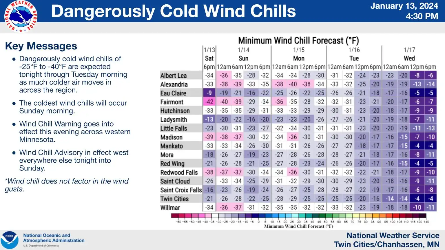
West-central Minnesota is in a wind chill advisory early Saturday evening, then it becomes a wind chill warning from 9 p.m Saturday to noon on Tuesday.
Southwestern Minnesota is in a wind chill warning, for wind chills as low as -40 to -50, that continues Saturday evening right through Sunday and Monday, ending at noon on Tuesday.
Most of the remainder of Minnesota is in a wind chill advisory from Saturday evening to noon on Tuesday. Western Wisconsin is in a wind chill advisory from midnight Saturday night until noon on Sunday.
In the Twin Cities metro area, the wind chill advisory begins at 9 p.m. Saturday and ends at noon on Tuesday:
MNZ043>045-050>053-059>063-068>070-077-078-140400- /O.EXT.KMPX.WC.Y.0001.240114T0300Z-240116T1800Z/ Morrison-Mille Lacs-Kanabec-Benton-Sherburne-Isanti-Chisago- Wright-Hennepin-Anoka-Ramsey-Washington-Carver-Scott-Dakota-Rice- Goodhue- Including the cities of Little Falls, Princeton, Mora, Sauk Rapids, Elk River, Cambridge, Center City, Monticello, Minneapolis, Blaine, St Paul, Stillwater, Chanhassen, Chaska, Victoria, Shakopee, Hastings, Faribault, and Red Wing 156 PM CST Sat Jan 13 2024 ...WIND CHILL ADVISORY NOW IN EFFECT FROM 9 PM THIS EVENING TO NOON CST TUESDAY... * WHAT...Very cold wind chills expected. Wind chills as low as 35 below zero. * WHERE...Portions of central, east central, south central and southeast Minnesota, including the Twin Cities metro area. * WHEN...From 9 PM this evening to noon CST Tuesday. * IMPACTS...The cold wind chills could cause frostbite on exposed skin in as little as 15 minutes. PRECAUTIONARY/PREPAREDNESS ACTIONS... Use caution while traveling outside. Wear appropriate clothing, a hat, and gloves. Don`t forget to limit the amount of time pets stay outdoors.
Dry Sunday
After patchy light snow on Saturday, Sunday is looking dry. The National Oceanic and Atmospheric Administration’s North American Mesoscale Forecast System model shows the potential precipitation pattern from 6 a.m. Sunday to 9 p.m. Sunday:
Temperature trends
Low temps early Sunday morning will be in the teens below zero in much of Minnesota, with single-digits below zero in most of the Twin Cities metro area plus western Wisconsin.
Sunday high temps will be below zero across most of Minnesota, and slightly above zero in western Wisconsin:

Parts of the Twin Cities metro area could touch zero.
Low temps early Monday will be in the teens below zero across most of Minnesota:

Monday high temps will be below zero in most of Minnesota:

Twin Cities metro area highs are projected to be around 5 above zero on Tuesday, followed by 16 degrees on Wednesday before retreating to 11 on Thursday and 8 degrees on Friday. Those are all chilly; the average Twin Cities high temperature is 23 degrees this time of year.
Temperatures may rebound nicely after next Saturday. The NWS Climate Prediction Center shows a tendency for above-normal temps in Minnesota and Wisconsin from Jan. 21 through Jan. 27:

We’ll see if that pans out.
Programming note
You can hear my live weather updates on MPR News at 7:35 a.m., 9:35 a.m. and 4:39 p.m. each Saturday and Sunday.