

Periods of snow to start the weekend: highest snow totals in northeastern Minn.
Substantial snow deficit in Minnesota

Go Deeper.
Create an account or log in to save stories.
Like this?
Thanks for liking this story! We have added it to a list of your favorite stories.
Minnesota has seen meager snowfall totals this snow season. The snow season begins in autumn and continues into early spring.
The snow tally at Minneapolis-St. Paul International Airport is just 5.3 inches so far this snow season. The Twin Cities snowfall total of 2.7 inches in October was slightly higher than the Twin Cities snowfall total for November plus December. 1913 is the only other year in Twin Cities weather records with more snow in October than in November and December combined.
Snow deficits
Here’s how our current season snowfall totals compare to normal snowfall to this point in our snow season:
Twin Cities: 15.1 inches below normal snowfall
Support Local News
When breaking news happens, MPR News provides the context you need. Help us meet the significant demands of these newsgathering efforts.
St. Cloud: 12.6 inches below normal
Duluth: 29.8 inches below normal
International Falls: 20.1 inches below normal
Rochester: 16.4 inches below normal
Flakes return Friday afternoon into Saturday
A low pressure system will spread snow into much of central and northern Minnesota plus northwestern Wisconsin from late Friday morning into Friday afternoon. The Twin Cities metro area could see an afternoon flurry.
Most of Minnesota and much of western Wisconsin will see periods of snow from Friday evening into Saturday afternoon. Snow will continue in some areas into Saturday night.
The National Oceanic and Atmospheric Administration’s North American Mesoscale Forecast System model shows the potential precipitation pattern from noon Friday to 11 p.m. Saturday:

How much snow?
The highest snow totals, 3 inches to as high as 6 or 7 inches, are expected in northeastern Minnesota and in parts of north-central Minnesota:
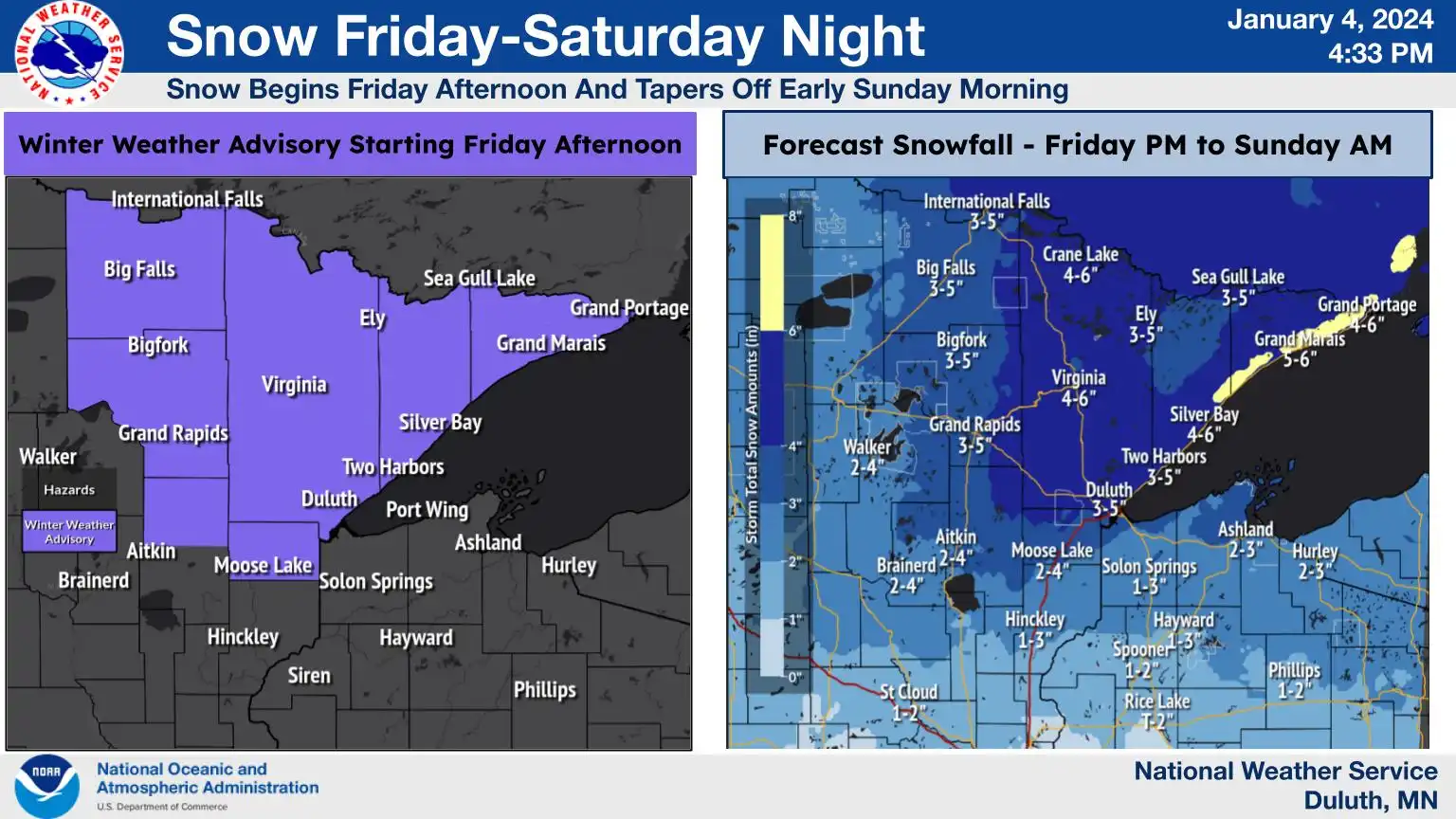
The winter weather advisory in Koochiching County plus Itasca County and Aitkin County, starts at noon Friday and runs to 6 p.m. Saturday. The winter weather advisory for St. Louis County and Carlton County plus Lake County and Cook County, starts at noon Friday and goes to 6 a.m. Sunday:
URGENT - WINTER WEATHER MESSAGE National Weather Service Duluth MN 246 PM CST Thu Jan 4 2024 MNZ011-012-019-037-050900- /O.CON.KDLH.WW.Y.0001.240105T1800Z-240107T1200Z/ North St. Louis-Northern Cook and Lake-Central St. Louis- Carlton and South St. Louis- Including the cities of Ely, Isabella, Hibbing, and Duluth 246 PM CST Thu Jan 4 2024 ...WINTER WEATHER ADVISORY REMAINS IN EFFECT FROM NOON FRIDAY TO 6 AM CST SUNDAY... * WHAT...Snow expected. Total snow accumulations of 3 to 6 inches. * WHERE...North St. Louis, Northern Cook and Lake, Central St. Louis and Carlton and South St. Louis Counties. This includes the Tribal Lands of the Fond du Lac Band and the Bois Forte Band, Lake Vermilion and, Nett Lake areas. * WHEN...From noon Friday to 6 AM CST Sunday. * IMPACTS...Plan on slippery road conditions. The hazardous conditions could impact the evening commute. * ADDITIONAL DETAILS...Total snow accumulations will be over a 36 hour period from Friday afternoon to Sunday morning, with the heaviest snowfall rates Friday evening through Saturday afternoon. PRECAUTIONARY/PREPAREDNESS ACTIONS... Slow down and use caution while traveling. The latest road conditions can be obtained by calling 5 1 1. Road conditions can also be found at 511mn.org for Minnesota or 511wi.gov for Wisconsin.
Parts of central Minnesota could see a couple inches of new snow Friday afternoon into Saturday, with closer to one inch possible in the Twin Cities metro area Friday evening into Saturday.
Here’s a look at the NWS statewide snow forecast:

You can hear updated weather information for Minnesota and western Wisconsin on the MPR News network.
Updated forecast information will be posted by the National Weather Service offices in the Twin Cities, Duluth, La Crosse, Wis., Sioux Falls, S.D., and Grand Forks, N.D.
Temperature trends
The average Twin Cities high temperature is 24 degrees this time of year. Metro area highs could recah the mid 30s on Friday.
Much of Minnesota and western Wisconsin will have Friday highs in the 30s, with 20s in far northern Minnesota:

A similar temperature pattern is expected on Saturday:

Sunday highs will be mainly in the 20s, with some teens in northwestern and north-central Minnesota:

Twin Cities metro area highs are projected to reach the lower 30s on Monday, then around 30 degrees Tuesday followed by upper 20s Wednesday and lower 20s on Thursday.
Programming note
You can hear my live weather updates on MPR News at 7:35 a.m., 9:35 a.m. and 4:39 p.m. each Saturday and Sunday.