Hot Labor Day; stormy Tuesday; then cooler
Go Deeper.
Create an account or log in to save stories.
Like this?
Thanks for liking this story! We have added it to a list of your favorite stories.
Near-record heat will continue for Labor Day. High temperatures should reach the 90s for most of the state, but quite a bit cooler near Lake Superior with Grand Marais “just” getting into the upper 70s.
The Twin Cities should have a July-like afternoon high near 97 with a southerly wind increasing to 15-25 mph. The record high for this date of 98 might be just out of reach. However, the record hottest Labor Day temperature of 97 (1913) in the Twin Cities has a better chance of being attained.
Heat Advisories continue
A heat advisory will continue through Tuesday afternoon for the Twin Cities area and from counties of southeastern Minnesota near the Mississippi River well into Wisconsin. Hot daytime temperatures and warm nights, along with a touch of humidity, will prevent much thermal relief.
Farther north, a heat advisory will be in effect only from 3 p.m. until 7 p.m. Monday from central Minnesota into northwestern Wisconsin.
Turn Up Your Support
MPR News helps you turn down the noise and build shared understanding. Turn up your support for this public resource and keep trusted journalism accessible to all.

Fire danger
Hot, dry weather, gusty winds and dry vegetation will create an enhanced wildfire danger Monday, especially during the afternoon and evening.
Isolated showers and thunderstorms
There have been some isolated showers and storms Monday morning, all tracking northeast. Here’s where they are at 9:15 a.m.

The heating of the day could generate a few more showers and possibly thunderstorms, mainly across the north. Meanwhile, strong storms are forecast to develop across the Dakotas as Monday heats up. Strong to severe storms should spread into northwestern Minnesota toward midnight at the end of Monday. There is a marginal risk (level 1 of 5) for severe weather Monday night in northwestern Minnesota.

Storm system moves in on Tuesday
The storm system and its cold front will advance slowly across Minnesota on Tuesday.

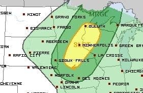
Ahead of the front, eastern Minnesota will have one last toasty day on Tuesday while western Minnesota, behind the front, cools a bit. Showers and thunderstorms will become widespread. Strong to severe storms are likely to develop across eastern Minnesota near and behind the cold front as the day heats up. A slight (level 2 of 5) risk of severe storms has been posted for Tuesday afternoon and evening from the Duluth area to the Twin Cities southwest to around Fairmont. The Twin Cities could see rounds of strong and possibly severe storms Tuesday evening.

Then turning much cooler
Wednesday through next weekend will bring comfortable September weather statewide. Lots of high temperatures will be in the 60s and 70s, with some days being cooler than normal. It looks like we might then be saying goodbye to sultry weather until next summer.


