

Warm, humid weekend with scattered showers, thunderstorms
Cooler air arrives in northern Minnesota Monday
Go Deeper.
Create an account or log in to save stories.
Like this?
Thanks for liking this story! We have added it to a list of your favorite stories.
Our Friday featured summery temps and dew points and scattered afternoon showers and thunderstorms.
The scattered showers and thunderstorms will continue into Friday evening. Some spots in Minnesota and western Wisconsin will see little or no rain, while other spots could see downpours at times.
Remember that it does not have to be raining at your location for lightning to strike nearby.
You can find updated weather information for Minnesota and western Wisconsin on the MPR News network. Find the latest radar here, and check these National Weather Service sites for updated weather info: Twin Cities, Duluth, La Crosse, Wis., Sioux Falls, S.D., Grand Forks, N.D.
Turn Up Your Support
MPR News helps you turn down the noise and build shared understanding. Turn up your support for this public resource and keep trusted journalism accessible to all.
Weekend rain chances
An isolated Saturday morning rain shower is possible, but the main Saturday rain chance will come with the heating of the day.
Scattered showers and thunderstorms are possible Saturday afternoon and evening in Minnesota and far western Wisconsin.
The National Oceanic and Atmospheric Administration’s High-Resolution Rapid Refresh model shows the potential rain pattern from noon Saturday to 11 p.m. Saturday:
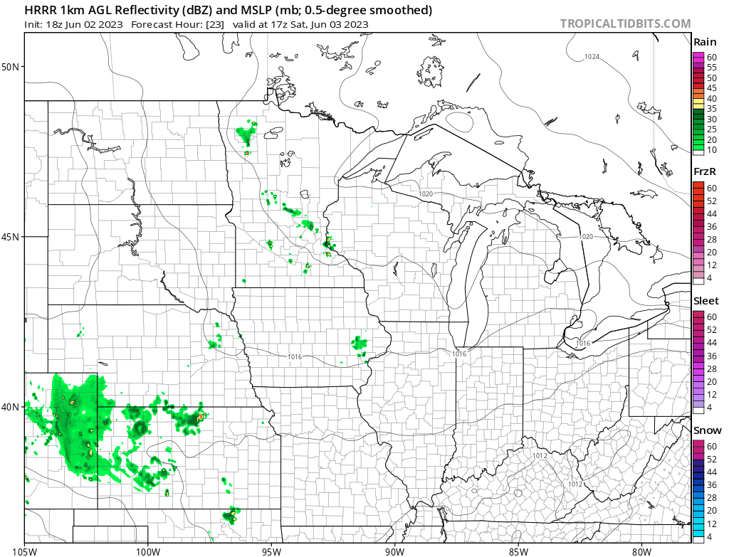
Pay more attention to the scattered nature of the rain than the exact location of the rain at any point in time. A few very scattered showers and thunderstorms could also develop in Minnesota Sunday afternoon.
Dense fog over western Lake Superior
Dense fog is expected to linger over western Lake Superior through Saturday morning:

We need some rain
The latest drought report from the U.S. Drought Monitor shows much of Minnesota is abnormally dry (yellow) and a portion of far southwestern Minnesota is in moderate drought (beige):

Temperature trends
The average Twin Cities high temperature is 75 degrees on June 3. Parts of the Twin Cities metro area could touch 90 degrees Saturday afternoon.
Saturday highs will be in the upper 80s to lower 90s across much of Minnesota and western Wisconsin:

Cooler 70s are expected near Lake Superior and in far northwestern Wisconsin.
Sunday highs will be well into the 80s in most areas, with lower 90s from the Twin Cities into southeastern Minnesota and west-central Wisconsin:

Cooler highs are expected near Lake Superior.
Monday high temps will be coolest in the northern half of Minnesota and northwestern Wisconsin, with upper 80s lingering to the south:

Twin Cities metro area highs are projected to reach the upper 80s on Monday, then around 80 degrees on Tuesday and Wednesday, followed by lower 80s on Thursday.
Programming note
You can hear my live weather updates on MPR News at 7:35 a.m., 9:35 a.m. and 4:39 p.m. each Saturday and Sunday.