

Hot, muggy with more late-day spotty storms; spring wrap-up
Highs near 90 again in southern Minnesota through the weekend
Go Deeper.
Create an account or log in to save stories.
Like this?
Thanks for liking this story! We have added it to a list of your favorite stories.
It’ll be another hot and muggy day Thursday with more late day thunder possible. Friday and Saturday bring much of the same. Meteorological summer is here, how did spring stack up?
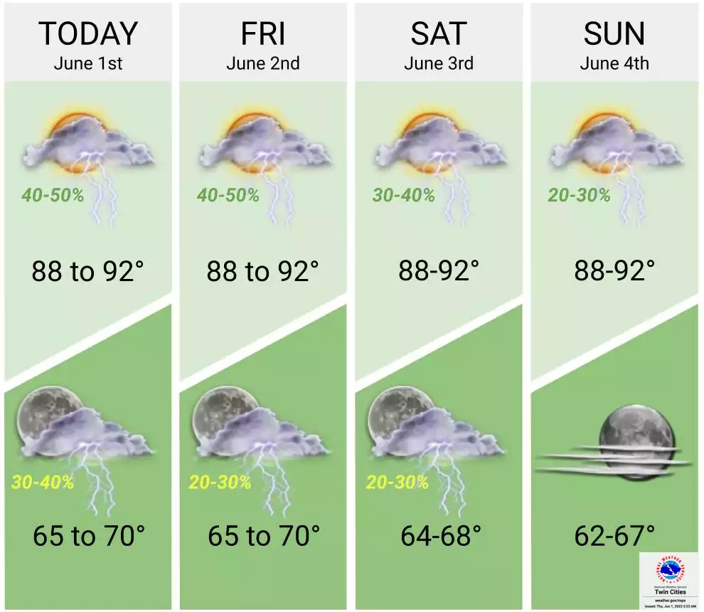
More heat, muggy air, thunderstorm chances
It’ll be another steamy one Thursday with highs back up near 90 and dew points in the sticky 60s. The North Shore continues to be cooler, mainly in the 70s.

Isolated and spotty thunderstorms will again pop up with daytime heating late Thursday afternoon into the evening hours. While most will remain dry, pinpointing where these showers develop will be difficult.

Friday will again be hot. In the Twin Cities we average three days in the 90s in June and Thursday and Friday may be our fourth and fifth this season.
Turn Up Your Support
MPR News helps you turn down the noise and build shared understanding. Turn up your support for this public resource and keep trusted journalism accessible to all.

The chances of rainfall increase a bit for Friday and Saturday with more scattered thunder potentially developing late in the day. Sunday and Monday bring lower chances of rain for most.

Meteorological spring 2023 by the numbers
Welcome to meteorological summer! Spring this year (March, April, May) was a mixed bag both in terms of precipitation and temperature. March was cold statewide, especially in the northwest. By May, temperatures were well above normal nearly statewide.
In the end, most of Minnesota except the southeast had a net temperature difference of 2 to 3 degrees cooler than normal.

Far southern Minnesota, west-central and northwestern Minnesota as well as the Arrowhead region saw a dry spring overall. The torrential downpours of early May near the Minnesota River valley are evident in the 90-day precipitation anomalies.

Here’s a view of some specific statewide precipitation values. The Twin Cities and Duluth had the biggest precipitation deficits but also reflect the spring pattern of a wet March but dry May. While most stations ended up near normal, most of Minnesota had a dry May.
