

Officials warn of extreme fire danger in northern Minnesota
Go Deeper.
Create an account or log in to save stories.
Like this?
Thanks for liking this story! We have added it to a list of your favorite stories.
State and federal land managers are warning of extreme fire danger across northeastern Minnesota, as a lack of precipitation, low humidity, warm temperatures and strong winds combine to create ideal conditions for wildfires.
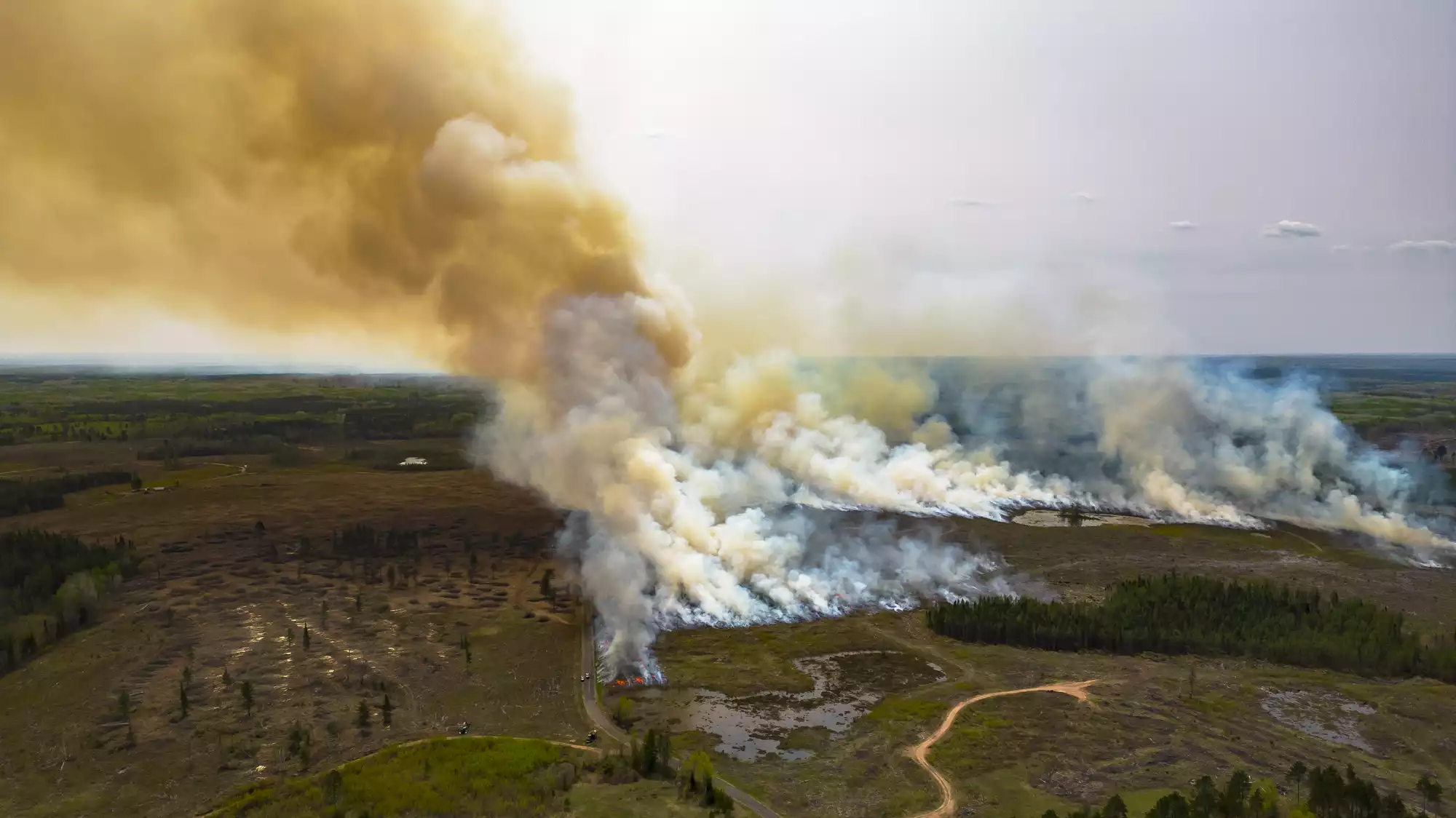
The Minnesota Department of Natural Resources reported 50 wildfires over the long Memorial Day weekend, stretching from central Minnesota northward to the Canadian border.
The two largest burned south of Ely, reaching about 10 and 20 acres in size. Their causes are still under investigation. The larger of the two, dubbed the Ely Fire, closed a stretch of the Taconite State Trail over the weekend.
Aircraft stationed nearby by the DNR and U.S. Forest Service helped douse the blazes from above, said Tim Engrav, a public information officer with the Superior National Forest.
Turn Up Your Support
MPR News helps you turn down the noise and build shared understanding. Turn up your support for this public resource and keep trusted journalism accessible to all.
Those wildfires “are a good indicator of the fuel conditions in the forest, how dry things are,” Engrav said. “And with some lower humidity the fires can start to go, especially with some wind behind them.”

‘Extreme’ fire risk around BWCAW
The Minnesota DNR’s most recent fire danger map shows high fire danger across the entire Arrowhead region, with extreme fire risk in a wide area in northeastern Minnesota around the Boundary Waters Canoe Area.
The conditions couldn’t be more different than just a few weeks ago, when a record snowpack blanketed much of northeastern Minnesota.
But there’s been little precipitation since the snow melted, said Leanne Langeberg, a public information officer with the Interagency Fire Center, who said conditions on the ground “are prime for wildfire activity.”
The forests in Minnesota are also going through what DNR officials refer to as the “spring dip,” Langeberg said. That’s a period during the spring green-up when needles in the crowns of pine trees dry out, making them more susceptible to fire.
“So the trees are a little bit more stressed during that time. And when you combine that with the drier conditions, that's when we start to see wildfire activity pick up,” explained Langeberg.

Burning restrictions
Rain is in the forecast this week but it’s expected to be spotty, Langeberg said — not the kind of wetting event that could help lower fire danger. “That dryness that is sitting upon us is is expected to hang in there throughout the month of June,” she said.
No open burning is allowed in northeastern Minnesota. Campfires are allowed, but officials urge campers not to leave fires unattended and to make sure embers are cold to the touch before they leave.
There’s also a chance for thunderstorms in the forecast this week, raising the possibility of wildfires caused by lightning strikes, Engrav said — because of dry soils at the top of the forest floor, and dry twigs and branches that can easily ignite.
“Right now we've been concerned about campfires and people being safe and prudent with their campfires. Now we'll also be monitoring for lightning.”