Quiet weather for Minnesota Saturday, heavy snow in parts of southern Wisconsin
Minnesota snow depth update
Go Deeper.
Create an account or log in to save stories.
Like this?
Thanks for liking this story! We have added it to a list of your favorite stories.
We’ll have fairly quiet Saturday weather in Minnesota.
Parts of northern and western Minnesota plus northwestern Wisconsin could see a passing sprinkle or light snow shower, but the main snow is off to the southeast.
The National Oceanic and Atmospheric Administration’s North American Mesoscale (NAM) forecast model shows the potential precipitation pattern from 9 a.m. to 10 p.m. Saturday:

A winter storm warning for heavy snow continues until 1 p.m. Saturday from east-central Iowa over to Rockford, Ill., and up to Madison, Wis. A winter storm warning continues until 4 p.m. today for southeastern Wisconsin, including Milwaukee and for far northern Illinois:
Turn Up Your Support
MPR News helps you turn down the noise and build shared understanding. Turn up your support for this public resource and keep trusted journalism accessible to all.

Here are winter storm warning details for Madison, Wis.:
URGENT - WINTER WEATHER MESSAGE National Weather Service Milwaukee/Sullivan WI 714 AM CDT Sat Mar 25 2023 WIZ063-068-251800- /O.CON.KMKX.WS.W.0006.000000T0000Z-230325T1800Z/ Dane-Green- Including the cities of Madison, Monroe, and Brodhead 714 AM CDT Sat Mar 25 2023 ...WINTER STORM WARNING REMAINS IN EFFECT UNTIL 1 PM CDT THIS AFTERNOON... * WHAT...Heavy snow. Total snow accumulations of 5 to 9 inches. * WHERE...Dane and Green Counties. * WHEN...Until 1 PM CDT this afternoon. * IMPACTS...Plan on slippery road conditions. Patchy blowing snow could significantly reduce visibility. PRECAUTIONARY/PREPAREDNESS ACTIONS... If you must travel, keep an extra flashlight, food, and water in your vehicle in case of an emergency. The latest road conditions for the state you are calling from can be obtained by calling 5 1 1.
Saturday temps
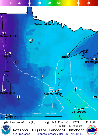
The Twin Cities average March 25 high temp is 46 degrees. Metro area highs will be in the low to mid-40s Saturday. Highs in the 40s are expected Saturday afternoon from eastern Minnesota into Wisconsin, with mainly 30s elsewhere:

Parts of northwestern Minnesota will have Saturday highs in the upper 20s.
Wind gusts over 30 mph are possible in the Red River Valley of northwestern Minnesota Saturday afternoon.
Snow cover
Much of Minnesota still has plenty of snow cover for cross-country skiing and sledding.
Here’s the latest Minnesota snow depth map from the Minnesota State Climatology Office:

Most of the northern half of Minnesota reported snow depths of 18 inches or higher this week, with snow depths of 30 inches or higher in much of northeastern Minnesota.
Twin Cities metro area snow depths vary from 12 inches or higher in the north metro to around 4 inches in parts of the southwest metro.
There’s little or no snow cover in much of southeastern Minnesota and in parts of far south-central Minnesota.
Programming note
You can hear my live weather updates on MPR News at 7:35 a.m., 9:35 a.m. and 4:39 p.m. Saturday and Sunday.


