8th snowiest season on record for the Twin Cities; next storm on the way Thursday
Duluth has already recorded 116 inches of snowfall this season.

Go Deeper.
Create an account or log in to save stories.
Like this?
Thanks for liking this story! We have added it to a list of your favorite stories.
This is a top 10 snowfall season for parts of Minnesota.
So far this winter the Twin Cities has recorded 80.3 inches (that’s 6.6 feet) of snow this season. That’s good enough for the 8th snowiest winter on record dating back to 1884.
And we’re now just 1” shy of the number 7 spot on the list. If we get another 4.6 inches of snow we’ll crack the top 5 snowiest seasons on record in the Twin Cities. The record for the snowiest season in the Twin Cities is 98.6 inches set in 1983-84.
9th snowiest season in Duluth
Turn Up Your Support
MPR News helps you turn down the noise and build shared understanding. Turn up your support for this public resource and keep trusted journalism accessible to all.
Duluth has recorded a whopping 116.4 inches (9.7 feet) of snow this season. That puts Duluth at the 9th snowiest winter season on record. Another half inch of snow will boost Duluth into the 8th snowiest spot. The record for season snowfall in Duluth is 135 inches set in 1995-96.
Duluth added another 2.3 inches of snow since the graphic below was posted Sunday.
Next storm ahead Thursday and Friday
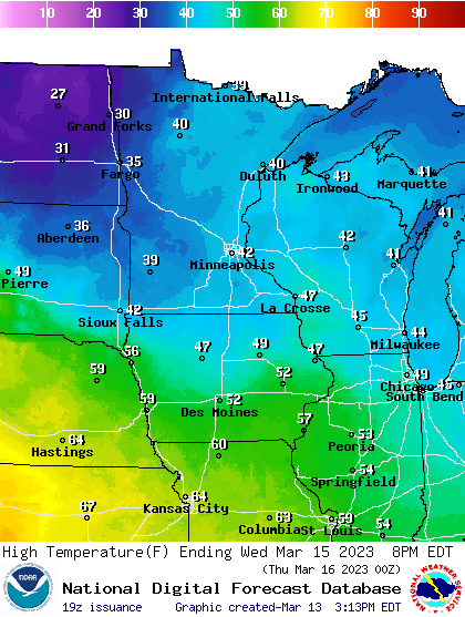
We come up for air through Wednesday between snow systems across Minnesota. Wednesday looks like the mildest day this week. Highs should reach the 40s in many spots Wednesday afternoon.

Our next system comes barreling in Thursday and Friday. The latest forecast models track this system from near Denver late Wednesday to near Milwaukee by Friday morning. If that forecast track holds, it’s favorable for significant snowfall across most of Minnesota from Thursday into Friday.
A few models keep temperature profiles above freezing Thursday across southern Minnesota including the Twin Cities. That would produce a rain-to-snow event as the system moves through. Right now it looks like all snow north of the Twin Cities, especially on either side of a Fargo to Brainerd to Duluth line.
The Canadian model is one of many that suggests a rain-to-snow sequence for the Twin Cities and southern Minnesota Thursday, with all snow later Thursday and Friday.

It’s still too early to be confident about where the heaviest snowfall totals will lay out. Any shift in storm track and or temperature profiles (rain-snow line) will make a big difference.
But this looks like another plowable snowfall event, with plenty of wind for much of Minnesota Thursday into Friday.
And we’re almost certain to see the Twin Cities and Duluth climb the top 10 season snowfall ladder once again later this week.
Stay tuned.


