

Epic and 'historic' winter storm begins Tuesday; 15 to 25 inch storm snowfall potential
Possible blizzard conditions peak Wednesday night into Thursday. Snowfall records may fall.
Go Deeper.
Create an account or log in to save stories.
Like this?
Thanks for liking this story! We have added it to a list of your favorite stories.
It’s hard to know just how forcefully to describe major winter storms as they approach Minnesota.
But all forecast model indications suggest our inbound Presidents’ Week Blizzard will produce serious to extreme impacts. And it could topple some decades-long snowfall records for the Twin Cities and southern Minnesota.
Here is the latest snapshot of where we stand as the late evening (0Z) forecast models come in on Presidents’ Day night.
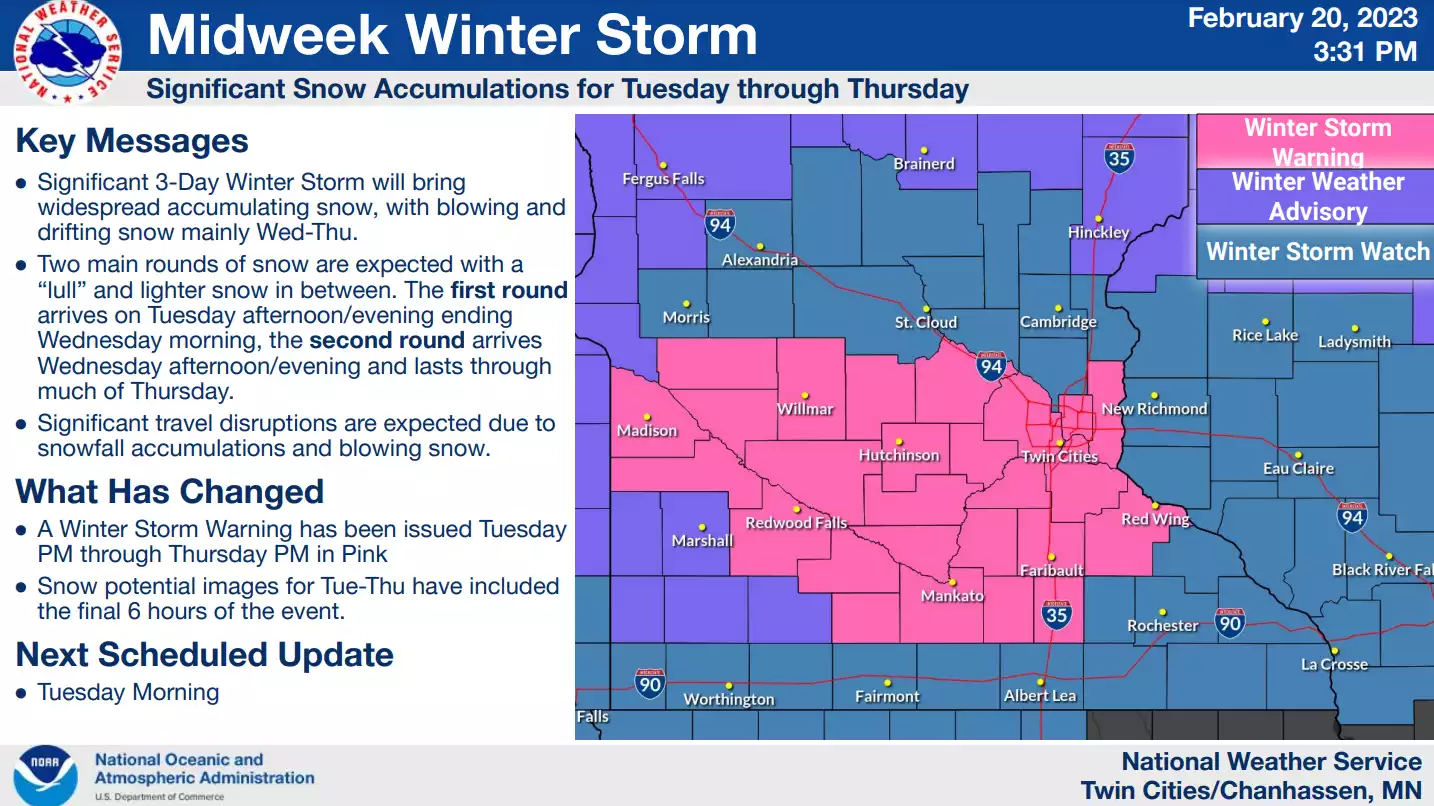
Winter storm warnings
Turn Up Your Support
MPR News helps you turn down the noise and build shared understanding. Turn up your support for this public resource and keep trusted journalism accessible to all.
Winter storm warnings go into effect Tuesday afternoon across southern Minnesota including the greater Twin Cities area. You can see the latest warning zone above. It will likely be expanded Tuesday.
Check out the enhanced wording from the warning text below.
Including the cities of Monticello, Minneapolis, St Paul, Stillwater, Hutchinson, Gaylord, Chanhassen, Chaska, Victoria, Shakopee, Hastings, St Peter, Le Sueur, Faribault, Red Wing, Mankato, Waseca, and Owatonna
855 PM CST Mon Feb 20 2023
...WINTER STORM WARNING REMAINS IN EFFECT FROM 3 PM TUESDAY TO 6 PM CST THURSDAY...
* WHAT...Heavy snow and blowing snow expected. Snow accumulations of 4 to 7 inches Tuesday and Tuesday night, followed by an additional 14 to 19 inches Wednesday afternoon into Thursday. For the entire storm, total accumulations will range from 18 to 25 inches. Winds gusting as high as 45 mph by Wednesday.
* WHERE...Portions of central, east central, south central and southeast Minnesota.
* WHEN...From 3 PM Tuesday to 6 PM CST Thursday.
* IMPACTS...Travel could be very difficult to impossible. Widespread blowing snow could significantly reduce visibility. * ADDITIONAL DETAILS...Significant drifting will occur due to the heavy snow totals and strong winds. Drifts may be several feet deep.
The system
The first wave of this intense 2-part storm arrives Tuesday afternoon. I like the way NOAA’s NAM 3 km model seems to have a pretty good handle on the initial snow zone. Snow likely begins in western Minnesota by midday, and spreads quickly east into the Twin Cities area by around 2-3 pm Tuesday.

This initial snow wave is likely to produce a range of 3 to 7 inches across much of southern Minnesota by Wednesday morning. There may be a lull in snowfall coverage and intensity Wednesday morning before the second wave arrives. But the most intense part of the storm will still be ahead.
Wave #2
The main body of this storm arrives Wednesday afternoon through Thursday. This is the deeper, stronger, windier part of the storm. Intense upper air support for this part of the storm will produce violent updrafts aloft. That will trigger convective snowbursts, capable of thundersnow and snowfall rates of 1 to 3 inches per hour Wednesday into Thursday.
NOAA’s NAM 3 km model shows you the darker blue blotches rippling northward. They indicate pockets of embedded heavy snow, with potential lightning and thunder.

The second part of the storm will produce the heaviest snowfall totals. This deep Colorado low is likely to dump 10 to 20 inches of snow in some areas. The worst of the wind and snow will occur Wednesday night into Thursday. Blizzard conditions are likely, and may even occur in parts of the Twin Cities.
Snowfall totals
It’s still unreal to see model-driven snowfall forecasts of 1 to more than 2 feet. But that’s exactly where most of the major forecast models have been for nearly a week now. And the consistency has been remarkable.
Here is the latest available NOAA/Twin Cities NWS model blend snowfall output.

Here’s a wider look at the entire state of Minnesota. While the heaviest snowfall zone strongly favors southern Minnesota, there will be significant snow and impacts up north.

Blizzard potential
I can’t remember the last time I saw Category 5 winter “extreme” storm impacts forecast for the Twin Cities area. And now the extreme impacts zone has been expanded to include much of southwest Minnesota as of Monday evening. We could see white-out conditions even in the Twin Cities by Thursday.

Record snowfall?
If the forecast of 15 to 25 inches of snow materializes for the Twin Cities, this will be a top 15 to top 2 snowfall event of record.

The all-time single-storm snowfall record for the Twin Cities is still the Halloween Mega-Storm in 1991 at 28.4” (Yep, that one.)
There are a few high-end snowfall forecasts that suggest we could challenge that 30+ year record, but they are on the extremely high end of forecast output.

Bottom line:
Expect snowfall to increase in coverage across southern Minnesota early Tuesday afternoon.
The first wave of snow will last through Tuesday night.
Wave #1 will likely produce 3 to 7 inches of snowfall.
There may be a brief lull in snowfall Wednesday morning.
Snow will crank up again rapidly Wednesday through the midday hours.
The heaviest snow and wind will occur Wednesday evening through Thursday.
Wave #2 is likely to produce 10 to 20 inches of snow in much of southern Minnesota.
Snowfall totals between 15 and 25 inches are quite possible across southern Minnesota including the Twin Cities.
Here are some actionable forecast preparations in these late hours.
Gather all supplies by noon Tuesday if possible.
Employers/employees/schools prepare for remote work if possible Tuesday PM through Thursday.
Stay updated for possible forecast changes through Thursday.
What could go wrong? The system could still change of course. The lead wave could produce less snow than currently forecast. Or the second wave could deliver fewer embedded multi-inch per hour snowbursts. But forecast models have been remarkably consistent for several days.
Stay tuned.