Roller-coaster temperatures continue through weekend
Minnesota sees dangerous cold through Friday with wind chills of minus 20 to minus 50
Go Deeper.
Create an account or log in to save stories.
Like this?
Thanks for liking this story! We have added it to a list of your favorite stories.
Another round of arctic air has settled across Minnesota, followed by a brief warmup then another frigid blast early next week. Chances of snow remain limited.
Arctic cold through Friday morning
As expected, the same storm that brought snow and high winds Wednesday ushered another blast of frigid weather into Minnesota.
Thursday morning temperatures are mostly in the negative teens, with a few negative single digits along the eastern edge of the state.
Although not the high winds of Wednesday, winds are still somewhat breezy, especially south. This combination of cold and wind is putting Thursday morning wind chills from minus 20 to almost 50 below zero. The coldest of those wind chills are more prevalent in western Minnesota where temperatures are the chilliest.

All of Minnesota is under either a wind chill advisory (blue) or wind chill warning (gray) through Friday morning, due to similarly dangerous cold expected overnight Thursday into Friday morning.
Afternoon temperatures (most highs for Thursday were set at midnight) also stay sub-zero, with negative teens northwest and negative single digits for the rest of the state.
Turn Up Your Support
MPR News helps you turn down the noise and build shared understanding. Turn up your support for this public resource and keep trusted journalism accessible to all.

The one spot that may make it above zero during the day is near Lake Superior, which is under the influence of the milder temperatures near the lake. Also, temperatures slowly warm as you head east.
Friday starts off dangerously cold, with air temperatures ranging from negative 30s northwest to negative teens south. This puts most wind chills at minus 20 to 50 below zero again.

Another warmup and drop
By late Friday morning, a southerly flow returns across Minnesota and temperatures begin warming back above zero. Much of Minnesota will set highs Friday at the end of the day, with temperatures rising overnight Friday.
This brings above-average temperatures back Saturday, with highs mostly in the 20s and a few 30s south.
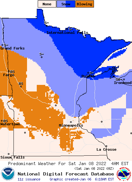
The same weather system responsible for the warmup (and eventual cool down) also brings light snow across northern Minnesota Friday night into early Saturday.

Even though most snow totals are expected to stay under 2 inches, gusty winds could still cause enough blowing snow to reduce visibilities Saturday morning.
The cold front side of the storm is forecast to sweep quickly across the state Saturday afternoon and evening, sending temperatures diving once again.
Sunday will be another day where most highs are set at midnight, with colder weather by the afternoon. The cold from Sunday morning to early Monday includes another round of dangerous wind chills, although they may not be as frigid as the current blast.
Here is the wind chill forecast for parts of Minnesota, showing some of the wind chills expected for the current arctic blast versus the projection for Sunday and Monday:

After the chill through Monday, warmer air returns Tuesday.

This is the forecast trend for The Twin Cities, showing the up and down temperatures (Friday’s high is likely to be at the end of the day. Sunday’s high is projected to come at the beginning of the day) :
Once Minnesota turns milder Tuesday, it looks like the temperature roller coaster ride finally take a break, with above average temperatures then continuing most of next week.
Programming note
You can hear my live weather updates on Minnesota Public Radio at 7:49 a.m. Monday through Friday morning.


