Tuesday snowstorm brings another arctic blast
High winds with thstorm will cause blowing snow and poor visibility

Go Deeper.
Create an account or log in to save stories.
Like this?
Thanks for liking this story! We have added it to a list of your favorite stories.
A winter storm poised to track directly over Minnesota Tuesday will bring areas of heavy snow, high winds and much colder temperatures behind it.
Incoming snowstorm
In the warmer part of an incoming storm, Minnesota is off to a relatively quiet and mild start Tuesday. Morning temperatures range from single digits north to 20s south, with even a few 30s southwest. This is about 10 to 20 degrees above average for a January morning.
Above average temperatures continue throughout the day, with afternoon highs in the teens north to 30s south.

As of 9:30 a.m. Tuesday, the low pressure center of the incoming storm is sitting just west of the border in South Dakota.
Turn Up Your Support
MPR News helps you turn down the noise and build shared understanding. Turn up your support for this public resource and keep trusted journalism accessible to all.

That low will start moving across southern Minnesota by the afternoon and clear east of the state by late Tuesday. The trajectory of the storm will initially bring some light snow into northern Minnesota by the afternoon. The wind pattern ahead of the storm is already causing some lake-effect snow in the Arrowhead.
Snow spreads through the rest of the state by Tuesday evening. Snowfall will be most persistent during the later evening and overnight hours, then wind down on Wednesday.
Total snowfall through Wednesday is forecast to vary from trace amounts south to a few spots with 5 or 6 inches north.

As the storm passes, there are very high winds behind it and gusts in southern Minnesota could exceed 40 mph late Tuesday into Wednesday. This will cause blowing snow and reduced visibility to continue even as the snow diminishes west to east Wednesday afternoon.
Whiteout conditions will be possible at times in areas of west-central Minnesota, especially from Moorhead south toward Redwood Falls.
Snow should finally clear east, coming to an end by Wednesday evening.
Because of the combination of snow, wind and reduced visibility from blowing snow, all of Minnesota is under a winter weather advisory by Tuesday evening. However, it is likely some areas will be upgraded to a winter storm warning, and a blizzard warning in west-central Minnesota is not out of the question.
We will keep you updated on MPR News with any of those updates.
Another arctic blast
The gusty winds behind the storm will draw another round of frigid air across the state.
Much of Minnesota will see Wednesday’s highs right at midnight, with falling temperatures during the day. The Twin Cities will be in the teens at midnight, but only around 5 degrees by late Wednesday afternoon.
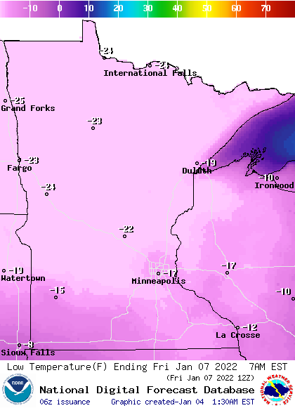
Temperatures continue to dive Thursday, with almost the entire state spending the day below zero. By Friday morning, dangerously cold temperatures in the negative teens south and negatives 20s south are expected.

Wind chills are expected to be minus 20 to minus 40 across much of Minnesota Friday morning, which is similar cold to what the state experienced this past weekend. Wind chill warnings and advisories are probable.
By Friday afternoon, most of Minnesota will be back above zero. Saturday is milder again. Another colder snap is likely early next week, continuing our recent trend of roller-coaster temperatures.
Here is that forecast for the Twin Cities:

The Wednesday and Thursday highs are both likely set right at midnight, with colder afternoon temperatures.
Programming note
You can hear my live weather updates on Minnesota Public Radio at 7:49 a.m. Monday through Friday.


