

Severe drought has now expanded across the Twin Cities
Minnesota sees less heat, but still stays too dry in the coming week
Go Deeper.
Create an account or log in to save stories.
Like this?
Thanks for liking this story! We have added it to a list of your favorite stories.
The storms, excessive heat and high humidity are being replaced by drier weather, which is not good news for Minnesota’s expanding drought conditions.
A new drought monitor came out Thursday with conditions collected through Tuesday morning. As we have seen through the summer, the below-average rainfall and hotter-than-average temperatures continue to intensify drought conditions.
Although there was a slight reduction of extreme drought in central Minnesota versus last week’s data, extreme drought is now affecting portions of southwestern Minnesota.
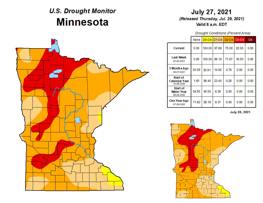
The overall portion of the state in extreme drought (shown in red) has now increased to 22 percent. The severe drought area (shown in dark orange) has also increased about 4 percent from last week. Severe or greater drought conditions now impact 75 percent of the state.
Turn Up Your Support
MPR News helps you turn down the noise and build shared understanding. Turn up your support for this public resource and keep trusted journalism accessible to all.
Drought conditions are also worsening in the Twin Cities metro area. Last week, most of the metro was in moderate drought, with only some of the northern suburbs in severe conditions. Now, almost all of the metro, including all of Hennepin and Ramsey counties, is in severe drought.
This means more communities are likely to enact or increase watering restrictions and other water conservation efforts.
Thursday’s forecast
The same storm system that pushed in the heat and humidity ahead of it and brought storms Wednesday moved a cold front across Minnesota Wednesday evening and through the overnight.
After record high dew points Wednesday, including a reading of 79 in the Twin Cities, dew points are dropping in southern Minnesota Thursday morning, and will be in the 50s by the afternoon. For northern Minnesota, the lower humidity has already moved in.
Thursday temperatures started warm, in the 60s north and 70s south, but a northerly wind flow is bringing in slightly cooler air versus the recent heat by the afternoon. Highs will be in the 70s north and 80s south.

Unfortunately, that wind pattern also brings back smoke back in from the fires in Canada, putting much of the state under an air quality alert Thursday.
Extended forecast
Minnesota returns to a drier pattern over the next week, with only spotty precipitation chances.
Some rain could come already Friday and Friday night though, with a disturbance moving across northern Minnesota.

Another storm system passes well south of the state but could bring a stray shower or storm near the Iowa border. Overall, rainfall prospects stay low though, with most of Minnesota unlikely to see any measurable rain through the weekend.

While the lack of rainfall is not good for the drought, upcoming temperatures are slightly better news. Temperatures turn more seasonable during the upcoming week, with 70s north and mostly low 80s south.
Here is that forecast for the Twin Cities:

Those “cooler” temperatures versus the heat Minnesota has seen much of the summer keep vegetation from drying out even faster.
Programming note
You can hear my live weather updates on Minnesota Public Radio at 7:48 a.m. Monday through Friday morning.