Steamy summer of '21: Hottest June on record so far
June heat is smashing multiple records across Minnesota.

Go Deeper.
Create an account or log in to save stories.
Like this?
Thanks for liking this story! We have added it to a list of your favorite stories.
The hot weather hits just keep on comin’ in the steamy summer of ‘21.
Our early-season heat wave continues to pile up records across Minnesota. In fact, the first 13 days of June in the Twin Cities and much of Minnesota were the hottest on record.
The average temperature at Minneapolis-St. Paul International Airport (all the daily highs and lows combined) for the first 13 days was a toasty 81.4 degrees. That’s a full 14 degrees warmer than average. It also smashes the previous record from 1976 by a full 5 degrees.
This map of monthly temperature departure from average shows the epicenter of the heat this month emanating outward from western Minnesota.

Multiple records
The Twin Cities numbers are a big metric so far this month. But there are many additional notable records around Minnesota.
Here are a few select records of note from the Minnesota DNR Climate Working Group.
Records of note set during June 2021 heat wave:
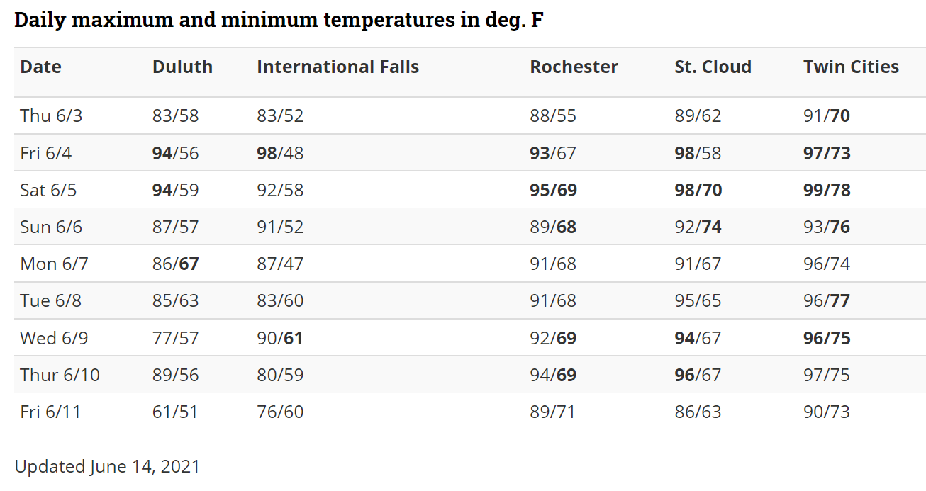
Duluth, June 4-5: earliest-in-season occurrence of two consecutive high temperatures above 90 F
International Falls, June 4: highest temperature on record so early in the season (98 F)
Twin Cities, June 5: highest minimum temperature on record so early in the season (78 F)
Twin Cities : most consecutive low temperatures at or above 70 F so early in the season (seven, ongoing)
Below is a table of daily highs and lows at Minnesota's five major climate stations, from June 3 through June 11, 2021. Bold numerals indicate a record for that date.

This is by most metrics the most intense early-season heat wave on record for Minnesota. Here’s more from the Minnesota DNR Climate Working Group.
Minnesota has had many historical heat waves that were "worse" than this one on numerous counts. However, at many locations, this was the longest and most severe heat wave to occur so early in the season. It's not unusual to have several days or more of 90-degree weather during the middle of July, but it is unusual to do so during (or before) the first half of June.
In the Twin Cities, where the heat-retaining urban and suburban infrastructure helped elevate temperatures even further, this heat wave has tied the record for consecutive high temperatures of at least 90 F on or before June 15, and obliterated the record for similar early-season consecutive low temperatures of at least 70 F--both officially at seven straight days through June 9th. The low temperatures in particular have been incredibly high in the Twin Cities, and so even though other historical heat waves produced higher daily maximum temperatures, none have come anywhere near this one in terms of daily average temperatures.
Turn Up Your Support
MPR News helps you turn down the noise and build shared understanding. Turn up your support for this public resource and keep trusted journalism accessible to all.


