

Flooding and heat concerns for Monday
Hot weather continues into next week
Go Deeper.
Create an account or log in to save stories.
Like this?
Thanks for liking this story! We have added it to a list of your favorite stories.
Heavy rain is causing flooding Monday morning, then the afternoon brings dangerous heat. Active weather stays through midweek, but the heat lingers even longer.
Monday’s forecast
A wide area of convection built up over southern Minnesota early Monday, bringing persistent thunderstorms with heavy rain to areas from the Twin Cities through the Minnesota River Valley. Here are some of the highest rain totals reports as of 9 a.m.:
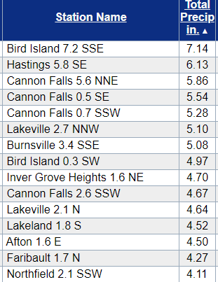
This has created areas of flooding which will continue through the morning, especially given additional storms moving across the state.

The widespread showers and storms move out by late morning, then the afternoon stays dry for most of the state. However, a few more showers and storms could develop Monday evening, with isolated areas seeing the potential for more heavy rain.
Turn Up Your Support
MPR News helps you turn down the noise and build shared understanding. Turn up your support for this public resource and keep trusted journalism accessible to all.
As the morning storms move out, the heat cranks up. Much of western and southern Minnesota could make it to 90 or above.

With very humid weather across the state, the heat indices will be near 100 in parts of southern and western Minnesota. Because of this, a heat advisory is in effect from 1 p.m. to 8 p.m. Monday for west-central Minnesota and the Twin Cities metropolitan area.

Active weather continues
The weather across Minnesota remains unstable the next few days, with occasional showers and storms likely through Thursday. The most likely time for wet weather is in the afternoons and evenings, and rain chances Wednesday are more widespread.

The active weather is being caused in part by a prevailing wind flow from the southeast. This has been funneling in very moist air, all the way from the Gulf of Mexico.
No break in the heat
Temperatures stay well above average all week, with highs in the 80s and 90s and high humidity.

By the holiday weekend, temperatures are even higher, with most of the sate in the 90s. Next week also looks likely to stay hot.
Programming note
You can hear my live weather updates on Minnesota Public Radio at 7:48 a.m. Monday through Friday morning.