50s arrive this week; rivers push higher
Go Deeper.
Create an account or log in to save stories.
Like this?
Thanks for liking this story! We have added it to a list of your favorite stories.
This is the week that spring came calling in Minnesota.
A fundamental change in the upper-air pattern across North America kicks in this week. The jet stream lifts north in Canada. A sustained flow of milder Pacific air blows into the Upper Midwest this week, and next.

Temperatures reach the mid-40s Tuesday and Wednesday across Minnesota. Highs in the 50s spread across the region Thursday through this weekend. It's going to feel a whole lot different out there.

Warmest air in 4+ months
Turn Up Your Support
MPR News helps you turn down the noise and build shared understanding. Turn up your support for this public resource and keep trusted journalism accessible to all.
Tuesday is day 137 since we've hit 50 degrees in the Twin Cities. In case you're wondering, it looks like this winter will result in the 10th longest run of temperatures below 50 degrees on record in the Twin Cities.
Here to stay?
Yes, we still get cold fronts in spring. And the Twin Cities averages about 3 inches of snow in April. But the current upper-air pattern looks like it has staying power.
The National Oceanic and Atmospheric Administration's three- to four-week outlook favors warmer than average temperatures in Minnesota.

Rising rivers
There are factors working for and against higher river levels in the next two weeks.
The warmer air will increase snowmelt this week. That will drive increased runoff and push many rivers higher. But little precipitation is in the forecast for the next week.
That's certainly good news for flood forecasters and those living near the flood zone.
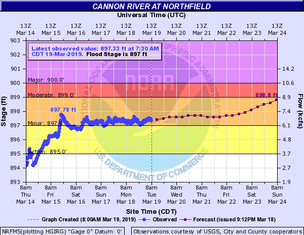
Many smaller and mid-sized rivers across southern Minnesota are already in flood. The Cannon River at Northfield is projected to push to near moderate flood stage this weekend.

The Minnesota River rises to moderate flood stage this weekend at Jordan.

And the Mississippi rises to minor flood stage in St. Paul early next week.

The good news is the dry forecast. If we get little rain as is now projected through most of next week, we may be able to avoid the worst-case flood scenario on many rivers.
Stay tuned.


