Arctic chill this weekend and beyond; Sunday snow update
Go Deeper.
Create an account or log in to save stories.
Like this?
Thanks for liking this story! We have added it to a list of your favorite stories.
Our average high temp this time of year is 24 degrees in the Twin Cities metro area. We won't see temps like that anytime soon.
On to the cold facts.
Temperature trends
Friday afternoon highs are expected to reach the single-digits below zero in roughly the northern half of Minnesota, with single-digits above zero in the south.
Turn Up Your Support
MPR News helps you turn down the noise and build shared understanding. Turn up your support for this public resource and keep trusted journalism accessible to all.
Here are more temperature details for northeastern Minnesota:

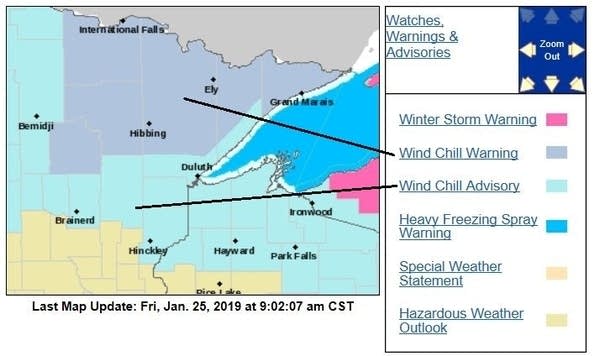
Wind chill warnings continue for much of northeastern Minnesota until noon this Friday, with wind chill advisories until noon for the remainder of northern Minnesota and northwestern Wisconsin:

Portions of southeastern Minnesota, including Rochester, also have a wind chill advisory until noon Friday.
Low temps late Friday night and early Saturday could drop to the 20s below zero in far northern Minnesota:

I wouldn't be surprised to see some spots in northeastern Minnesota dip below minus 30.
On Saturday, highs range from single-digits either side of zero in the north to teens in the far south:

Sunday highs retreat a bit in the south:

Th
Twin Cities metro area highs are expected to be around 10 degrees on Monday, followed by highs in the single-digits below zero on Tuesday and Wednesday.
Low temperatures early Tuesday will be in the teens below zero, with lows near minus 20 early on Wednesday and Thursday.
The last time that the temp hit minus 20 at Minneapolis-St. Paul International Airport was on Dec. 18, 2016.
Sunday snow
Snow is expected to move into western Minnesota Sunday morning, then spread into eastern Minnesota and western Wisconsin as we go through Sunday afternoon and evening. The snow continues Sunday night into early Monday.
The National Oceanic and Atmospheric Administration’s North American Mesoscale forecast model shows the potential snow pattern as we go from Sunday morning through Monday afternoon:

The color chart to the right of the loop refers to the strength of the signal that returns to the radar, not to the amount of snow.
The Twin Cities metro area will be near the northern edge of the heaviest snow, with the highest snow totals expected to fall from west-central Minnesota to southeastern Minnesota:

Check forecast updates, because the snow band could shift. At this point, it looks like the metro area will see enough snow to shovel and plow from Sunday afternoon into Monday morning.
As always, updated weather information can be heard on the Minnesota Public Radio Network, and you’ll also see updated weather info on the MPR News live weather blog.
Minnesota snow cover
Although there's very little snow on the ground in the Twin Cities metro area, there is plenty of snow cover throughout the rest of Minnesota. Here’s the latest Minnesota snow depth map from the Minnesota State Climatology Office:

Programming note
You can hear my live weather updates on Minnesota Public Radio at 7:49 a.m. Thursdays and Fridays, and at 7:35 a.m., 9:35 a.m. and 4:35 p.m. each Saturday and Sunday.


