Chilly weekend to wrap up September
Go Deeper.
Create an account or log in to save stories.
Like this?
Thanks for liking this story! We have added it to a list of your favorite stories.
Frosty temperatures broke out across most of Minnesota except parts of the southwest early this Saturday.
The official low for the Twin Cities, measured at MSP airport, was 36. I saw just some light frost on rooftops in Minneapolis. But the suburbs and outlying areas, away from the center of the urban heat island, saw many low 30s. St. Cloud had a low of 27, Baudette got down to 24, and temperatures in the low 30s were reported right down to the Iowa border in south central and southeastern Minnesota.
Temperatures were prevented from dropping even lower by an insulating blanket of thickening clouds from the Dakotas.
Furnace on?
Turn Up Your Support
MPR News helps you turn down the noise and build shared understanding. Turn up your support for this public resource and keep trusted journalism accessible to all.
Temperatures will be slow to recover over the next few days. A chilly air mass and abundant clouds to keep out much sunlight will prevent significant warming. Look for highs on Saturday from just the low 40s in northeastern Minnesota around Isabella to the low 50s in the south. The Twin Cities should reach about 51 on a day with an average high of 66.
Sunday should be a few degrees warmer for both the minimum and maximum temperatures.
Here is a quick look at some of the upcoming weather:

Flakes and showers
An area of scattered precipitation spread into western Minnesota Saturday morning. Snow flurries were being reported at Slayton at 8 a.m. Scattered showers, mainly of the rain variety, will continue to break out as the temperature warms a bit today. The radar beam from the Twin Cities is angled slightly upward, so most of the precipitation shown on the radar is actually in the cloud layer and will evaporate before it can reach the ground. The green colors probably indicate wet snowflakes aloft as wet snowflakes look a lot like big raindrops on radar.

Scattered light showers are likely again on Sunday.
Chance of thunderstorms on Monday
Widespread showers are likely across Minnesota Sunday night and on Monday. Scattered thunderstorms might be a good bet across southern portions of the state on Monday. Flash flooding might be possible from central Iowa across southeastern Minnesota into southern Wisconsin.

Hurricane Rosa
You will note that the above forecast map also indicates a very large area of potential flash flooding in the Desert Southwest including the Las Vegas area by Tuesday. The perpetrator will be Hurricane Rosa now over the eastern Pacific.

Rosa is a category 2 hurricane with maximum sustained winds of 100 mph. Although Rosa will weaken to a tropical depression by the time it reaches the US, very heavy rain is likely to cause flash flooding and debris flows in susceptible desert areas.
Rosa remnants to Minnesota
Rosa's leftovers are likely to continue on toward the northeast, up to the Upper Midwest by midweek. We should expect a widespread rain event with the possibility of some thunderstorms by about Wednesday,
Cooler again by next weekend
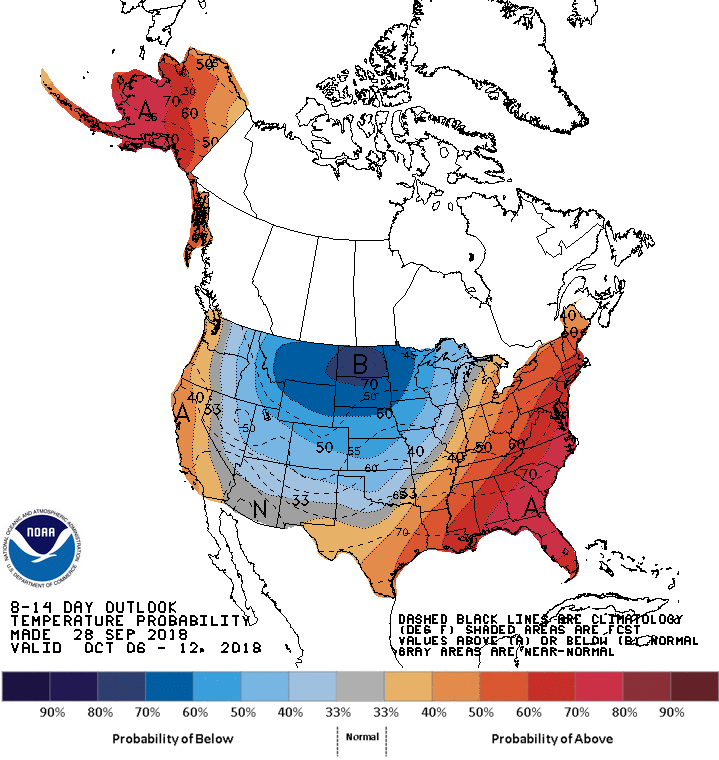
Canadian air will make a return visit later next week after Rosa departs. The 8 - 14 day temperature outlook for Oct. 6 to Oct. 12 paints a picture of quite an outbreak of colder-than-normal temperatures when we reach the first weekend of October and begin the next week.


