Florence’s flooding rains continue; a summery weekend for Minnesota
Go Deeper.
Create an account or log in to save stories.
Like this?
Thanks for liking this story! We have added it to a list of your favorite stories.
Hurricane Florence's sustained winds dropped to 70 mph late Friday afternoon, so Florence is now a tropical storm:
"Crawls" is a good description, since tropical storm Florence has been moving westward at only about 3 mph this Friday afternoon.
The slow movement of Florence will drop additional heavy rain on areas that have already seen flooding rains:
Flooding will continue across much of North Carolina this weekend:
Turn Up Your Support
MPR News helps you turn down the noise and build shared understanding. Turn up your support for this public resource and keep trusted journalism accessible to all.
Sadly, some fatalities have been reported:

More rain
Florence will continue to drop flooding rains over North Carolina and parts of South Carolina as we go into the weekend.
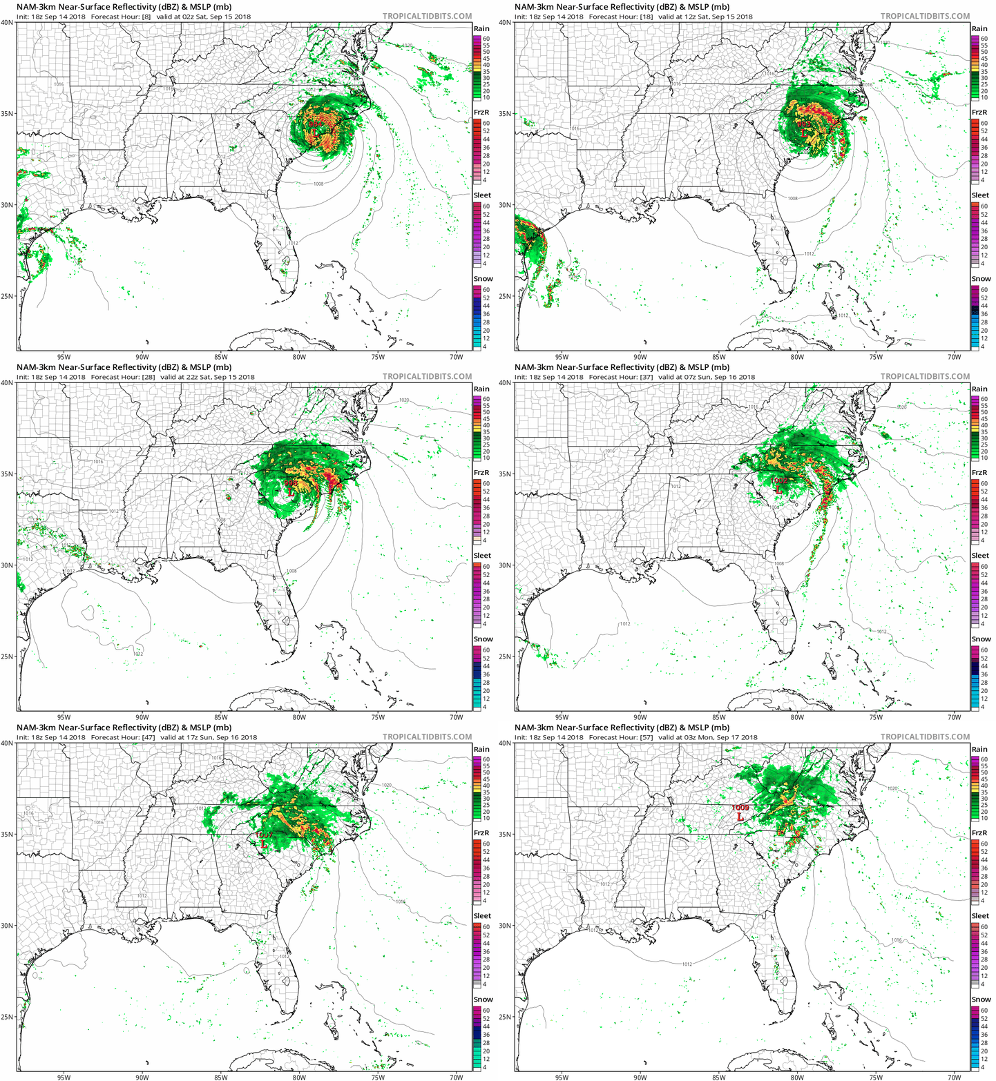
The National Oceanic and Atmospheric Administration's North American Mesoscale forecast model shows the potential rain pattern from this Friday evening through Sunday evening:

The color chart to the right of the loop refers to the strength of the signal that returns to the radar, not to the amount of rain.
Some areas could see additional rainfall amounts of 10 to 20+ inches:

Florence update
Here’s the Friday evening update on Florence, from the National Hurricane Center:
BULLETIN
Tropical Storm Florence Intermediate Advisory Number 62A
NWS National Hurricane Center Miami FL AL062018
800 PM EDT Fri Sep 14 2018
...FLORENCE'S CENTER MOVES INTO EXTREME EASTERN SOUTH CAROLINA...
...LIFE-THREATENING STORM SURGES AND STRONG WINDS TO CONTINUE
TONIGHT...
...CATASTROPHIC FRESHWATER FLOODING EXPECTED OVER PORTIONS OF NORTH
AND SOUTH CAROLINA...
SUMMARY OF 800 PM EDT...0000 UTC...INFORMATION
----------------------------------------------
LOCATION...33.9N 78.8W
ABOUT 15 MI...25 KM NNE OF MYRTLE BEACH SOUTH CAROLINA
ABOUT 55 MI...90 KM ESE OF FLORENCE SOUTH CAROLINA
MAXIMUM SUSTAINED WINDS...70 MPH...110 KM/H
PRESENT MOVEMENT...W OR 270 DEGREES AT 3 MPH...6 KM/H
MINIMUM CENTRAL PRESSURE...975 MB...28.79 INCHES
WATCHES AND WARNINGS
--------------------
CHANGES WITH THIS ADVISORY:
None.
SUMMARY OF WATCHES AND WARNINGS IN EFFECT:
A Storm Surge Warning is in effect for...
* Myrtle Beach South Carolina to Salvo North Carolina
* Pamlico Sound, including the Neuse and Pamlico Rivers
A Tropical Storm Warning is in effect for...
* Edisto Beach South Carolina to Cape Hatteras North Carolina
* Pamlico Sound
Interests elsewhere in the southeastern and mid-Atlantic states
should monitor the progress of Florence.
For storm information specific to your area, including possible
inland watches and warnings, please monitor products issued by your
local National Weather Service forecast office.
DISCUSSION AND OUTLOOK
----------------------
At 800 PM EDT (0000 UTC), the center of Tropical Storm Florence was
located by NOAA Doppler radar near latitude 33.9 North, longitude
78.8 West. Florence is moving toward the west near 3 mph (6 km/h). A
slow westward to west-southwestward motion is expected through
Saturday. On the forecast track, the center of Florence will move
farther inland across extreme eastern South Carolina tonight and
Saturday. Florence will then move generally northward across the
western Carolinas and the central Appalachian Mountains early next
week.
Maximum sustained winds are near 70 mph (110 km/h) with higher
gusts. Gradual weakening is expected tonight. Significant weakening
is forecast over the weekend and into early next week while Florence
moves farther inland.
Tropical-storm-force winds extend outward up to 175 miles (280 km)
from the center. Within the past hour or two, a sustained wind of
55 mph (89 km/h) and a gust to 68 mph (109 km/h) were reported at
the National Ocean Service station at Johnny Mercer Pier in
Wrightsville Beach, North Carolina.
The estimated minimum central pressure based on nearby surface
observations is 975 mb (28.79 inches).
HAZARDS AFFECTING LAND
----------------------
STORM SURGE: The combination of a dangerous storm surge and the
tide will cause normally dry areas near the coast to be flooded by
rising waters moving inland from the shoreline. The water has the
potential to reach the following heights above ground...
The Neuse, Pamlico, Pungo, and Bay Rivers...8-12 ft
Cape Fear NC to Salvo NC...3-5 ft
Myrtle Beach SC to Cape Fear NC...2-4 ft
The deepest water will occur along the immediate coast in areas of
onshore winds, where the surge will be accompanied by large and
destructive waves. Surge-related flooding can vary greatly over
short distances. For information specific to your area, please see
products issued by your local National Weather Service forecast
office.
RAINFALL: Florence is expected to produce heavy and excessive
rainfall in the following areas...
Southeastern coastal North Carolina into far northeastern South
Carolina...an additional 20 to 25 inches, with isolated storm totals
of 30 to 40 inches. This rainfall will produce catastrophic flash
flooding and prolonged significant river flooding.
Remainder of South Carolina and North Carolina into southwest
Virginia...5 to 10 inches, isolated 15 inches. This rainfall will
produce life-threatening flash flooding.
Rainfall totals exceeding 16 inches thus far have been reported at
several locations across southeastern North Carolina.
WIND: Tropical storm conditions will continue through Saturday
morning in portions of the warning area along the coast and also
over large portions of eastern North Carolina and extreme eastern
South Carolina, with tropical storm force wind gusts spreading well
inland.
TORNADOES: A few tornadoes are possible in eastern North Carolina
through tonight, mainly near southeast coastal areas after dark.
SURF: Swells generated by Florence are affecting Bermuda, portions
of the U.S. East Coast, and the northwestern and central Bahamas.
These swells are likely to cause life-threatening surf and rip
current conditions. Please consult products from your local weather
office.
The projected path of the center of Florence, from the National Hurricane Center:

Summery Minnesota weekend
Dew point temps will reach the upper 60s to around 70 degrees in much of southern and central Minnesota this weekend.
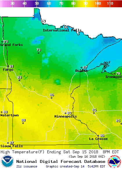
Saturday afternoon highs will be well into the 80s in southern and central Minnesota:

A few spots in the Twin Cities metro area and far southern Minnesota could touch 90.
80s will be common across most of Minnesota on Sunday:

A few spots in the northeast will see highs in the 70s.
Twin Cities highs are expected to be in the lower 80s Monday, followed by lower 70s Tuesday and around 70 Wednesday and Thursday.
Rain chances
The northern half of Minnesota will have the best chance of showers and thunderstorms Friday evening and overnight Friday night.
A few scattered showers and thunderstorms will also be possible in northern Minnesota on Saturday.
Updated weather information can be heard on the Minnesota Public Radio Network, and updates are also posted on the MPR News live weather blog.
Sunday looks mostly rain-free, but some periods of showers and thunderstorms are expected across much of Minnesota Monday through Thursday.
Programming note
You can hear my live weather updates on Minnesota Public Radio at 7:49 a.m. Thursdays and Fridays, and at 7:35 a.m., 9:35 a.m. and 4:35 p.m. each Saturday and Sunday.


