

3-day January Thaw, huge model spread on Thursday snow
Go Deeper.
Create an account or log in to save stories.
Like this?
Thanks for liking this story! We have added it to a list of your favorite stories.
Get ready for one more balmy January day Wednesday.
It felt like (very) early spring in much of Minnesota Tuesday. Temperatures soared into the 40s across southern Minnesota as we rode the northern edge of an unseasonably warm air mass. Thermometers pushed 60 degrees as far north as Kansas and Nebraska.

The mercury hit 42 degrees at MSP Airport. That's the warmest day in 3 weeks (since December 18th) and the 4th warmest January 9 on record in the Twin Cities.

One more mild day
Turn Up Your Support
MPR News helps you turn down the noise and build shared understanding. Turn up your support for this public resource and keep trusted journalism accessible to all.
We have one more mild day to get our cars washed and driveways scraped off before temperature take the plunge on Thursday and into the upcoming weekend. Temperatures top 40 degrees again across southern Minnesota Wednesday. Then the Arctic air returns.

Models: Still high uncertainty on Thursday snowfall
It still looks like snow on Thursday. But if a trend is emerging it leans toward lower snowfall totals for the Twin Cities and southern Minnesota, with heavier snows favoring northeast Minnesota and Wisconsin.
Let's start with the latest look from the Twin Cities NWS. Notice they have significantly lowered snowfall forecast for the Twin Cities and much of central and southern Minnesota since Tuesday morning's map. Winter storm watches remain in effect.

Twin Cities: 1" to 11"?
No we probably won't see that big of a snowfall range across the Twin Cities. But the American models are still showing an unusually high snowfall spread as we hit 36 hours to go time.

Euro: 1" to 3"?
The European model (ECMWF) is leaning toward the lighter side of the snowfall envelope for the Twin Cities. The latest Euro puts out just .16" of liquid precip for Minneapolis. That would translate into about 1" to 3" snow for most of the metro.

Tale of two models
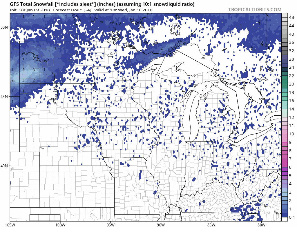
To illustrate how wide the range of possible snowfall outcomes for the Twin Cities is, check out these two models. First NOAA's GFS. It suggest a general 1" to 3" range for most of southern Minnesota including the Twin Cities. The GFS places the heaviest (6"+) snow stripe from Iowa, through Rochester and Winona, into Wisconsin.
Now here's NOAA's NAM 12 km resolution model. This one paints the heavy snow band (9"+) right over the Twin Cities metro.
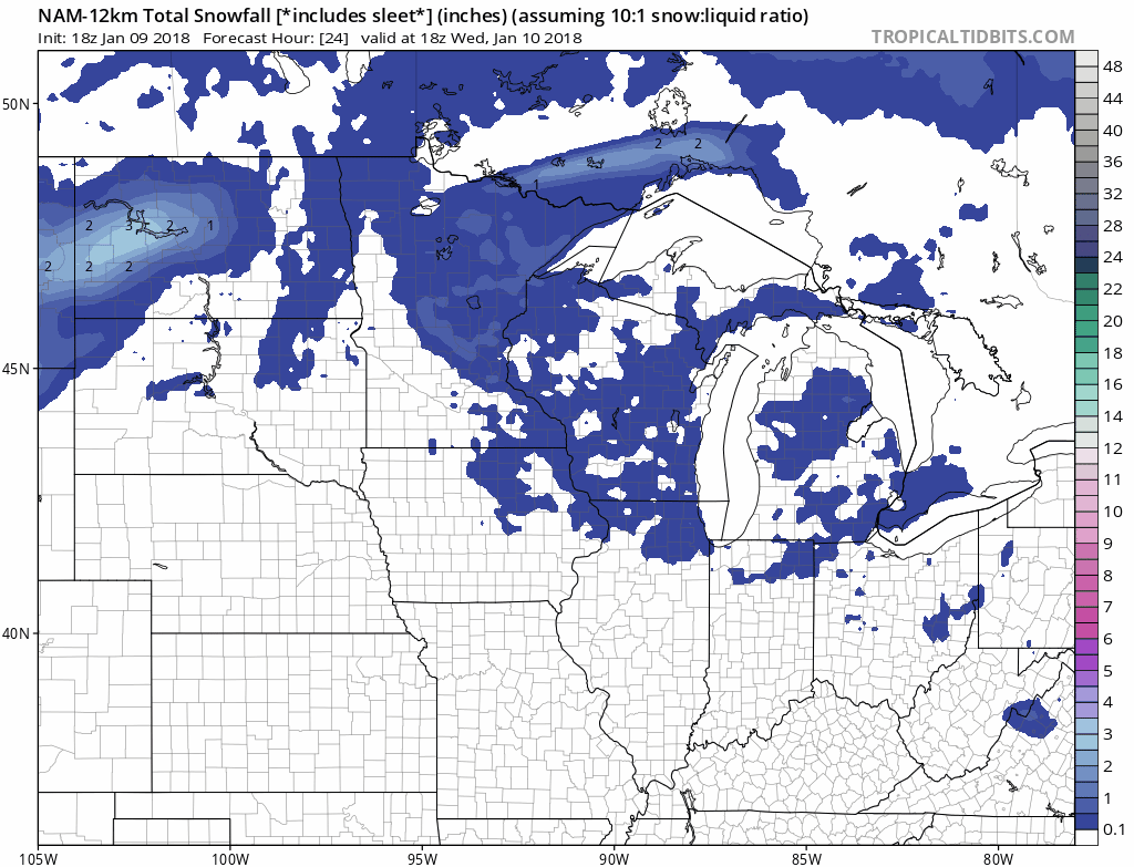
Bottom Line: There is still a higher than usual degree of uncertainty about the precise placement of the heavy snow band with this system. Right now I am leaning toward the Euro and GFS solutions that would favor 1" to 3" for the Twin Cities. But that may change pending Wednesday's model runs.
Snow Thursday is highly likely. The amount of snow is still highly uncertain. Anyone who expresses a higher degree of certainty at this point is selling you a bill of goods.
Stay tuned.