My Winter Outlook: Colder and snowier than last year
Go Deeper.
Create an account or log in to save stories.
Like this?
Thanks for liking this story! We have added it to a list of your favorite stories.
It's that time of year again. Winter forecasts are flying around left and right. The Almanacs. The private forecasters. NOAA. The woolly bear?
Cue the Winter Misery Index.
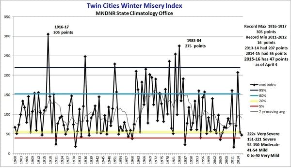
Higher uncertainty this winter?
The view from the Huttner Weather Lab in early November suggests forecast uncertainty is higher than usual for the upcoming winter. The one clear high probability prediction at this point is to plan for a winter that's significantly colder than last year's El Niño-fueled winter, the 6th warmest on record on Minnesota.
Turn Up Your Support
MPR News helps you turn down the noise and build shared understanding. Turn up your support for this public resource and keep trusted journalism accessible to all.
Here's a look at some factors that go into this winter's forecast across the Upper Midwest.
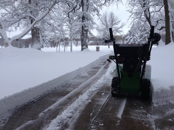
Last winter: El Niño-fueled warmth
First a quick look back at last winter. The massive El Niño delivered on predictions of a warmer than average winter. It was the warmest winter on record for the lower 48 U.S. states. Parts of northern Minnesota ran 10 degrees warmer than average last winter.
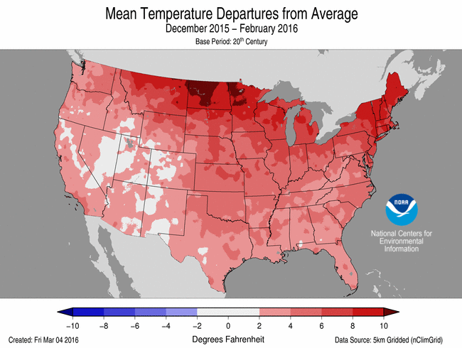
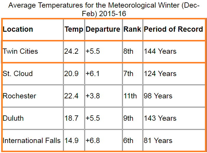
Temperatures last winter ran 5.5 degrees warmer than average in the Twin Cities. It was the 6th warmest winter on record in Minnesota, and the 8th warmest in the Twin Cities.
Season snowfall was scarce in the Twin Cities. The season total reached just 36.7", almost 20" shy of average.
Many forecasters correctly grabbed hold of the developing El Nino and predicted a mild winter. Here's a clip from my winter forecast a year ago compared actual observed temps and snowfall.
My temperature prediction for the Twin Cities and Minnesota: Temps for meteorological winter (Dec-Feb) 2015-16 will land somewhere between 4 and 8 degrees warmer than average. This could turn out to be one of the mildest winters on record in parts of Minnesota. (Actual temps +5.5F, 6th mildest winter in Minnesota)
My snowfall prediction for the Twin Cities and Minnesota: Snowfall for the Twin Cities will land somewhere between 35 and 45 inches this winter. (Actual MSP snowfall was 36.7")
'Baby La Niña' winter ahead?
Significant changes are occurring in the tropical Pacific this year. Last winter's massive El Niño event is history. Cooler waters are now pooling in the equatorial Pacific.
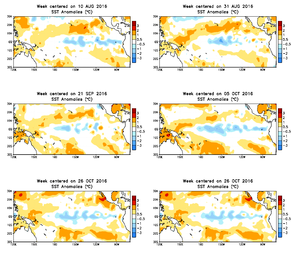
Odds slightly favor a developing La Niña event this winter, but the signal in the tropical Pacific is not nearly as clear as last year. Could we see a 'baby La Nina' this winter?
Here's an excerpt from NOAA's latest ENSO Diagnostic Discussion.
ENSO Alert System Status: La Niña Watch
Synopsis: La Niña is favored to develop (~70% chance) during the Northern Hemisphere fall 2016
and slightly favored to persist (~55% chance) during winter 2016-17.
The multi-model averages favor borderline Neutral-La Niña conditions (3-month average Niño- 3.4 index less than or equal to -0.5°C) persisting during the Northern Hemisphere fall and continuing into the winter (Figs. 6 and 7). Because of the recent cooling in the Niño-3.4 region and signs of renewed atmospheric coupling, the forecaster consensus now favors the formation of a weak La Niña in the near term, becoming less confident that La Niña will persist through the winter. In summary, La Niña is favored to develop (~70% chance) during the Northern Hemisphere fall 2016 and slightly favored to persist (~55% chance) during winter 2016-17 (click CPC/IRI consensus forecast for the chance of each outcome for each 3-month period).

If La Niña conditions do develop, odds usually favor a colder than average winter across the norther tier of the USA.

Bottom line: Odds very slightly favor a La Niña event this winter. La Niña events favor colder and snowier than average winters in the northern USA. But the slight odds and possible weak strength of a La Niña event create higher than usual uncertainty about possible effects across the northern USA.
NOAA: Buying into La Nina
NOAA's U.S. Winter Outlook appears to have bought into the iffy La Niña signal.
October 20, 2016
Forecasters at NOAA’s Climate Prediction Center issued the U.S. Winter Outlook today, saying that La Nina is expected to influence winter conditions this year. The Climate Prediction Center issued a La Nina watch this month, predicting the climate phenomenon is likely to develop in late fall or early winter. La Nina favors drier, warmer winters in the southern U.S and wetter, cooler conditions in the northern U.S. If La Nina conditions materialize, forecasters say it should be weak and potentially short-lived.
NOAA also predicts above average precipitation across the northern USA.

AER: Banking on high October Siberian snow cover again
We've been keeping track of Judah Cohen at AER for the past few years. Judah is the primary proponent of tracking Siberian snow cover in October and projecting winter temperatures based on that. His theory links above average Siberian snow cover to a negative phase of the Arctic Oscillation in winter. A negative AO favors for more frequent bitter Arctic outbreaks over North America and Europe in winter.
Cohen has had some successes in the past. But last winter even though he cited uncertainty with the developing El Niño, he stuck with the correlation between higher autumn snow in Siberia and projected a colder than average winter across the USA. That didn't work out too well. The massive El Niño even (and the background hum of climate change) overwhelmed all other factors and produced the mildest winter on record for the USA.
This October snow cover ran higher than average once again in Siberia. As you might expect, AER is also leaning colder than average this winter across a good chunk of the USA.


Weather Lab Winter outlook
I'll be honest, the mixed data means my confidence is far lower this year looking ahead into winter. Last winter was pretty much a slam dunk no brainier, and the forecast turned out perfectly. I'm not as confident this year.
Looking at this winter, I see three trends that may dictate winter temperatures and snowfall for Minnesota.
La Niña
My read on the possible La Niña is that it will trend weak, and short-lived. I don't think the odds are as high that La Niña will deliver a colder than average winter this year. I'm not ready to (fully) buy into the notion of a colder than average winter this year due to La Niña
Climate change
What's the strongest signal of our continued climate warming in Minnesota? Warmer winters. Minnesota is the fastest warming state in winter in the lower 48 U.S. states.
The continued forcing of our warming climate on Minnesota winters is well measured.
That trend in the magnitude warmer winters will vary from year to year, but the constant forcing is there. It's getting harder to buck the overall trends of milder than average winters in Minnesota. We'll still get some colder than average winters, but statistically a forecast for a milder than average winters will be accurate far more often going forward.
Persistence
Minnesota is in a well established trend of significantly warmer than average temperature over the past 14 months. Temperatures at MSP Airport have been warmer than average every month since September 2015. During that time, temperatures are running 4.2 degrees warmer than average at MSP. Warm air in the Arctic and Alaska has also been persistent. That means there has not been a strong pool of cold air to draw from during periods of northwest flow aloft.

We'll need frequent major cross-polar pattern shifts driving cold from Siberia to favor sustained colder than average conditions over Minnesota this winter. For Minnesota this winter, that old weather saying "the trend is your friend" may be apt.

My winter outlook for the Twin Cities and Minnesota:
So here's my best shot at our Minnesota winter forecast as of early November. I'll admit part of this is gut feel this year, part data-driven. In short, this winter may run near or slightly midler than average. In other words, a semi-real Minnesota winter.
Significantly colder (and snowier) than last winter, which was the 6th warmest on record in Minnesota.
Temps for meteorological winter (Dec-Feb) 2016-17 should land between 0 (average) to 3 degrees warmer than average across Minnesota.
Snowfall in the Twin Cities should be near average. I project between 50"and 60" snowfall overall in the Twin Cities. The 30 year average (1981-2010) snowfall for the Twin Cities is 54.4". I could see parts of northern Minnesota exceeding 70" this winter.
A mild fall and early November means lakes will be late to freeze this year.
December may be warmer than average.
I expect to see high variability in temps this winter. One or two major 'Polar Vortex' style Arctic outbreaks are likely this winter.
Mild spells and moderate temps should punctuate this winter. One or two significant thaws should occur and eat away at snow cover.
This should be a much better winter for outdoor events like pond hockey tournaments and winter festivals.
Overall I see temperatures running milder than average across the USA this winter.
Look for one or two Polar Vortex outbreaks to lead the national news.
Look for two major Nor'easters to dump snow on the east coast.
Question: Will the string of record warmth globally continues this winter?
Overall confidence is lower this winter. Some things we can say for sure in Minnesota in winter? It will get cold. It will snow. Commutes will be snarled. Minnesotans will laugh and play in the snow and delight in the winter season.
What do you think? Please share your winter forecast in the comments below.


