

Weekend soaker; 2015 warmest on record globally so far

Go Deeper.
Create an account or log in to save stories.
Like this?
Thanks for liking this story! We have added it to a list of your favorite stories.
Weather practitioners catch a lot of grief during a long Minnesota winter. Do we get a bonus for a picture perfect weather week in April?
75 degrees - high temp at MSP Airport Friday
5th day this April at or above 70 degrees
+5 degrees vs. average this month
+10 degrees vs. April 2014

There may be a little good news for everyone in the weekend forecast.
Support Local News
When breaking news happens, MPR News provides the context you need. Help us meet the significant demands of these newsgathering efforts.
Our weekend weather is a split decision. How about a mostly dry and mild Saturday, then a much needed soaking rain Saturday night and Sunday? That's the likely sequence of events this weekend as a fairly respectable low pressure system pushes a few waves of rain and some thunder into the Upper Midwest.

The latest model runs have slowed the system down a few hours. A wave of rain showers gathers in southwest Minnesota Saturday and moves northeast.
We may squeak out a mostly dry Saturday in the Twin Cities and points east, but by early evening all bets are off as bands of showers and embedded thunderstorms move in.
Saturday night and Sunday look just plain wet, as much needed April showers and a few embedded thunderstorms roll through. A good Sunday to curl up with a good book and your favorite weather blankie?
Here's a closer breakdown of the weekend by the hours for the Twin Cities.

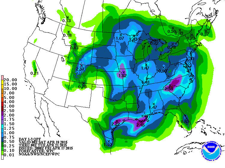
Rainfall totals look impressive with this system. A good half-inch looks like a lock, with many rainfall totals at or above the 1-inch mark this weekend.
April reality check next week
We've been leading charmed weather lives this April. So far this month temperatures are running a full 5 degrees warmer than average in the Twin Cities and most of Minnesota, and about 10 degrees warmer than last April.
That changes next week. Our upper air flow turns northwest, and that brings temperatures as much as 30 degrees colder for a few days next week.

Bye bye 70s; hello 40s!

And yes, we can't rule out a few renegade snow flakes around Minnesota next week. Right now I don't see any significant accumulations in most of Minnesota, but the far north may see a little on the ground. Heavy snow falls next week in Ontario!

2015 warmest on record so far globally
Last year was the warmest year on record globally. Now, the National Oceanic and Atmospheric Administration reports the first quarter of 2015 was the warmest year on record so far.

Global highlights: Year-to-date (January–March 2015)
During January–March, the average temperature across global land and ocean surfaces was 1.48°F (0.82°C) above the 20th century average. This was the highest for January–March in the 1880–2015 record, surpassing the previous record of 2002 by 0.09°F (0.05°C).
