Sun returns as winter trends sunnier

Go Deeper.
Create an account or log in to save stories.
Like this?
Thanks for liking this story! We have added it to a list of your favorite stories.
The sun came out this morning after 10 straight gray days at the Weather Lab.
Somebody alert the media. Wait. I am the media.
"Quick, grab the camera and get this," I thought to myself this morning as the strange bright object climbed above the southeast horizon.
Turn Up Your Support
MPR News helps you turn down the noise and build shared understanding. Turn up your support for this public resource and keep trusted journalism accessible to all.
10 consecutive cloudy days in Minnesota through Tuesday
December is second cloudiest month of the year historically
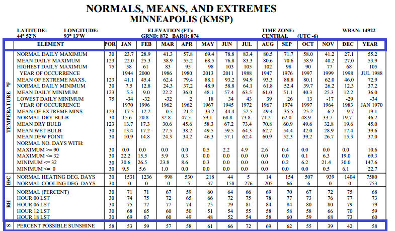
42 percent of possible sunshine historically in December in the Twin Cities
53 percent of possible sunshine in January historically
The good news for sun deprived Minnesotans? Winters trend sunnier historically as we move forward.
We're moving past the cloudiest time of the year, on average, in Minnesota. November is the cloudiest month of the year historically with just 39 percent of possible sunshine on average. December sunshine run 42 percent, with January at 53 percent.
By the time we get to February 59 percent of all daylight hours are sunny historically.
Progress. Hope. Optimism.
Here are the percentages of possible sunshine for each month of the year from the Twin Cities National Weather Service and Minnesota Climatology Working Group.

Warming trend
We bottom out today as temps stagger into the lower 20s. Lighter winds under high pressure overhead make it feel a little less harsh today. Temps moderate the rest of the week as winds shift into the south on the back side of retreating Canadian high pressure.

Temps rise through the 20s tomorrow. The mercury climbs above 30 degrees this weekend as another, more diminutive thaw kicks in this weekend. The next low pressure wave arrives Later Sunday into Monday with a wintry rain/sleet/snow mix.

Squeaking out a barely white Christmas?
Models from the European Centre for Medium-Range Weather Forecasts and the National Oceanic and Atmospheric Administration's Global Forecast System suggest some light snows as colder air returns next week.
Will we get just enough snow early next week to meet the technical definition of 1 inch snow cover for a white Christmas? I'd give it a 50/50 shot at this point.
Barely white.

In the longer run, the GFS is cranking out some colder temps to close out 2014. We're probably not sustained talking polar vortex level cold here, but we should be making some ice on Minnesota lakes the last week of 2014.

Looking through what amounts to a murky night-vision weather scope, the GFS is hinting at another potential West Coast storm and Midwest thaw as we move into the first days of January.

My gut is this will be the trend this winter -- periods of typical winter cold punctuated by periodic thaws. So far, I very much like where I left my winter outlook in early November with the prediction of near average temps this winter with a high degree of variability.
On the edge of El Nino
The Australian Bureau of Meteorology's fortnightly update this week confirms we remain on the edge of a developing El Nino. The Japan Meteorological Agency was the first to officially call it an El Nino event last week.
Tropical Pacific sea surface temperatures's continue to run into El Nino territory, and some typical El Nino atmospheric effects have developed while some others have yet to unfold. A sign of a weak El Nino event?
Here's more from the Australian bureau:

Here's a good look at El Nino from the Australian Bureau of Meteorology.
The developing El Nino patterns increase the odds Minnesota will continue to see a much milder winter than last year. I still think we'll get an attention getting stab of arctic air or two this winter, but I just don't see the prolonged savage sub-zero runs of last winter.
Stay tuned.


