

Hydro Vortex: 3″+ rainfall and counting soaks in, icy havoc up north
Go Deeper.
Create an account or log in to save stories.
Like this?
Thanks for liking this story! We have added it to a list of your favorite stories.
Welcome to the Land of 10,000 New Lakes.
The waves of persistent rain that battered Minnesota the past two days continue to sweep across the state today. My dad would have called this a good old-fashioned rainstorm. I'd call it living a car wash.
5.61 inches April precipitation so far at Minneapolis-St. Paul International Airport
4th wettest April on record, so far
Support Local News
When breaking news happens, MPR News provides the context you need. Help us meet the significant demands of these newsgathering efforts.
The nature of this rain is widespread and soaking. A huge area of central and southern Minnesota is counting up multi-inch rainfall totals, with 2 to 3 inches-plus across a big swath of real estate.
The deluge the past two days is along the Interstate 94 corridor, including the Twin Cities, and southwest along the Minnesota River.
Check out the seven-day rainfall totals from the National Oceanic and Atmospheric Administration's Advanced Hydrologic Prediction Service. Most of the rain fell Sunday and today.

This long duration soaking rain should pretty much wipe out some areas of drought and dryness in Minnesota.
Compare the rainfall area to the latest U.S. Drought Monitor and you can see the rainfall has soaked into a good chunk of the area in Minnesota classified in drought and abnormally dry.

Parts of southwest Minnesota have received less rain. That's where the drought is deepest, so some drought may linger in the southwest.
The soaking rains have kept farmers out of the fields for now, but are probably good news in the long run for the upcoming growing season. This week should help replenish soil moisture at deep levels, and that could help if things dry out again later this summer.
This is already the fourth wettest April on record at MSP Airport. We may be gunning for number two by Wednesday night.

Hydro Vortex: persistent cutoff low spins overhead
The culprit for our late April Minnesota monsoon? A powerful low pressure system cutoff from the main jet stream. The low hangs around through this week, crawling toward Chicago before finally ejecting to the east. That keeps the precipitation shield over Minnesota right through Thursday.

How much more?
Rain may mix with snow and ice at times over northern Minnesota this week. As the low slides east, coverage and intensity of rainfall should diminish a bit. But another 1 to 2 inches-plus of moisture is likely over Minnesota by this weekend.

I don't think I've seen such a persistent rainmaker system across Minnesota in a few years. It may be marginally cold enough to mix in some wet snowflakes as far south as the metro Tuesday into early Wednesday morning. Yes...snow.

Yes, this weather is depressing turn of events for many of us. I just keep repeating the mantra, "we need the rain. It will warm up eventually."
But then again I'm an eternal optimist. Hang in there Minnesota. It's the best option I can think of!

Mille Lacs ice invasion
How do you know it's spring in northern Minnesota? When weird things start happening with ice instead of snow.
Here's the scene from Garrison on Mille Lacs Lake as high winds on Sunday triggered an "ice shove" onto the lake's west shore.
http://www.youtube.com/watch?v=Cw_VyO_A0p4
Icy windy havoc
Temperatures with the system have been just cold enough to produce freezing rain in the Arrowhead and along the North Shore. High winds are gusting more than 50 miles per hour.
What happens when you coat trees with ice and throw in 50-plus mph winds?
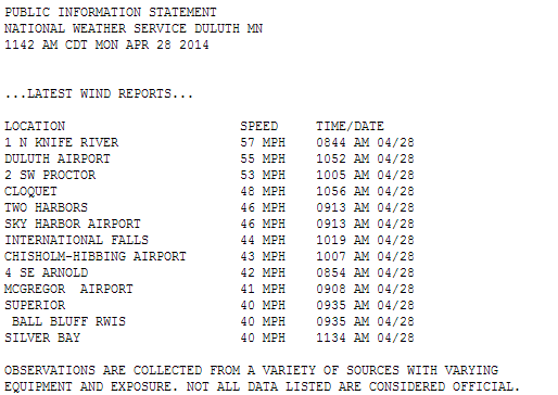
I've seen a lot of crazy National Weather Servivce local storm reports, but never anything quite like this one from NWS Duluth.
Flying ice in the air in Proctor??

Just when I though I'd seen it all.
Outbreak: Tornado death toll rises
The devastation and death toll from Sunday's tornado outbreak in Arkansas and the Southern Plains continues to grow. I knew it was a very bad sign when I saw this "debris ball" clearly on the Little Rock, Arkansas, Doppler last night.

Debris balls occur when tornadoes pick up debris from the path of devastation. The intense tornadic updrafts suck everything from dust to chunks of damaged homes to trees up into the air, and the Doppler radar beam sees this as a "high reflectivity" ball on the radar display.
It's a bad and usually deadly sign that a massive tornado has plowed into homes and other debris sources.
http://www.youtube.com/watch?v=4UUA_fO9M48
Severe risk continues
The severe risk continues tonight in the Deep South. NOAA has placed another "high risk" for severe weather and tornadoes over Mississippi.
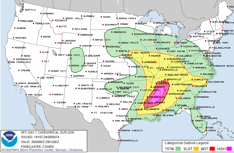
When the chance of tornadoes is extremely high, NOAA upgrades the usual tornado watch to a higher level. "Particularly dangerous situation" tornado watches are flying tonight for the Deep South.

An 85 percent chance of one or more EF2-EF5 tornadoes? That's a bad situation.

Stay tuned, its going tot be another rough night for tornadoes in the Deep South.