Mild temps through Wednesday, then chilly
Shower chances Sunday and Monday highest to the north
It was ideal weather for Twin Cities Marathon runners and spectators Sunday morning. Temps started out in the 50s and rose into the 60s. There wasn’t any rain to deal with and winds were fairly light.
Rain chances?
The best chance of occasional scattered showers as we go through the remainder of Sunday will be in northern and central Minnesota, plus northwestern Wisconsin. An isolated shower is possible elsewhere in Minnesota and western Wisconsin.
You can check the MPR News interactive radar here. There’s fairly dry air in the lowest part of atmosphere this weekend, so some of the rain that shows up on radar will evaporate before reaching the ground
Create a More Connected Minnesota
MPR News is your trusted resource for the news you need. With your support, MPR News brings accessible, courageous journalism and authentic conversation to everyone - free of paywalls and barriers. Your gift makes a difference.
We have updated weather information for Minnesota and western Wisconsin on the Minnesota Public Radio News network, and on the MPR News live weather blog.
On Monday, northern Minnesota will have the best chance of scattered showers. Shower chances arrive in western Minnesota later in the day. The National Oceanic and Atmospheric Administration’s High-Resolution Rapid Refresh (HRRR) model shows the potential rain pattern from 7 a.m. Monday to 10 p.m. Monday:

Temperature trends
Our average Twin Cities high temp is 66 degrees this time of year.
Sunday afternoon highs will reach the lower 70s in much of the Twin Cities metro area. Highs in the 70s are expected in roughly the southwestern half of Minnesota, with upper 70s possible in the southwest. Highs will be mainly in the 60s elsewhere in Minnesota and western Wisconsin, with a few 50s near Lake Superior.
Most of Minnesota and western Wisconsin will have Monday highs in the 70s:

Temps retreat a bit in northern Minnesota on Tuesday, with 70s lingering elsewhere:

Twin Cities metro area highs are projected to reach the lower 70s Wednesday. A cold front moves through Wednesday night, so metro highs will be in the lower 50s on Thursday and around 50 on Friday. I should mention that Twin Cities metro area lows are expected to be in the 30s Friday morning.
Fall color update
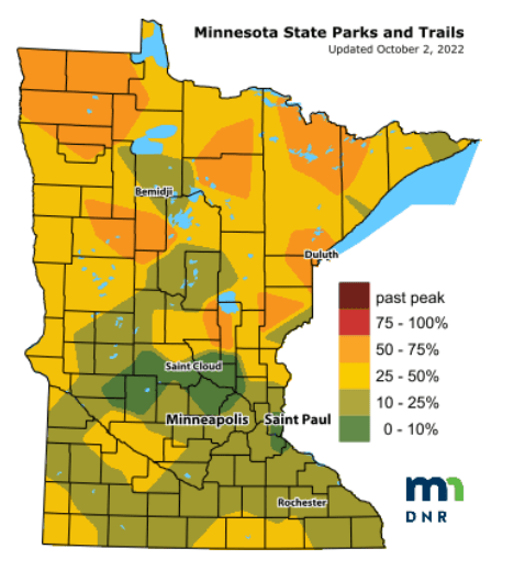
The Minnesota Department of Natural Resources fall color report for Minnesota State Parks and Trails looks like this:

When you look at fall color maps, keep in mind that all deciduous trees are included. The maples can be peaking when the overall changeover to fall color is less than 50 percent in a given area.
I saw great fall colors eleven days ago in Minnesota’s Arrowhead region along the Sawtooth Mountains, inland from Lutsen and Tofte. I’m sure that those fall colors have expanded to include many more areas since then.
The Wisconsin fall color report can be found here.
Weather nugget
Last October, Twin Cities high temps were in the 70s for the first 11 days of the month. October 2021 ended up 6.1 degrees warmer than normal in the Twin Cities.
Programming note
You can hear my live weather updates on MPR News at 7:35 a.m., 9:35 a.m. and 4:39 p.m. Saturday and Sunday.