Periods of showers and possibly a thunderstorm Saturday morning; cooler temps
Sunday looks dry
Lingering areas of showers are expected Saturday morning in mainly the eastern half of Minnesota plus western Wisconsin. There could be an embedded thunderstorm too. Western Minnesota could see an isolated morning shower.
An isolated shower or t-storm is still possible early in the afternoon in eastern Minnesota and western Wisconsin. The National Oceanic and Atmospheric Administration’s North American Mesoscale (NAM) forecast model shows the potential rain pattern from noon to 10 p.m. this Saturday:

You can hear updated weather information for Minnesota and western Wisconsin on the Minnesota Public Radio News network, and you can see updated weather info on the MPR News live weather blog.
Cooler temps
Create a More Connected Minnesota
MPR News is your trusted resource for the news you need. With your support, MPR News brings accessible, courageous journalism and authentic conversation to everyone - free of paywalls and barriers. Your gift makes a difference.
Our official Twin Cities high temp was 96 degrees on Thursday and 91 on Friday. A cool front will usher in cooler highs today.
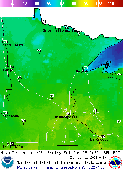
Our average Twin Cities high on June 25 is 82 degrees. We’ll top out in the lower 80s in the Twin Cities plus southeastern Minnesota and most of western Wisconsin Saturday afternoon:

Much of Minnesota will have highs in the 70s.
Saturday afternoon dew points will be in the sticky 60s to the east, with more comfortable 50s in the west:

Update
A new Updraft blog will be posted by around 10:20 a.m. with a look at Sunday and the week ahead.
Programming note
You can hear my live weather updates on MPR News at 7:35 a.m., 9:35 a.m. and 4:39 p.m. each Saturday and Sunday.