Breezy, cooler and less humid on Sunday
Comfortable temps to start the work week
The official Twin Cities high temperature Saturday afternoon was 83 degrees. That’s very close to our average June 25 high of 82 degrees. It probably felt a bit refreshing to some people, after two days with highs in the 90s.
A combo of a low pressure system to the northeast and a high pressure system to our west will funnel even cooler and drier air into Minnesota Saturday night and Sunday.
Temperature trends
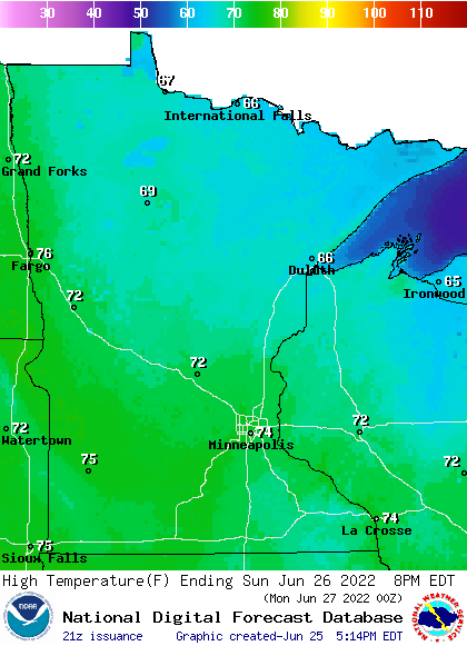
It’ll be breezy on Sunday. Highs will be in the 70s in most of Minnesota and west-central Wisconsin, with 60s in north-central and northeastern Minnesota and northwestern Wisconsin:
Create a More Connected Minnesota
MPR News is your trusted resource for the news you need. With your support, MPR News brings accessible, courageous journalism and authentic conversation to everyone - free of paywalls and barriers. Your gift makes a difference.

Dew points will be in the very comfortable 40s:

Monday highs will be mainly in the 80s, with some 70s in northeastern Minnesota and western Wisconsin:

Twin Cities metro area highs are projected to be in the lower 80s Monday, followed by mid 80s Tuesday and upper 80s Wednesday, then around 90 on Thursday followed by lower 80s Friday.
Rain chances on Sunday?
Most of Minnesota will have dry weather Saturday evening. Western Wisconsin and far southeastern Minnesota could see some scattered showers and an isolated thunderstorm early Saturday evening, then all the rain is expected to move off to the east.
Far northern Minnesota could see a few scattered showers on Sunday. The National Oceanic and Atmospheric Administration’s North American Mesoscale (NAM) forecast model shows the potential rain pattern from 3 a.m. Sunday to 9 p.m. Sunday:

You can hear updated weather information for Minnesota and western Wisconsin on the Minnesota Public Radio News network, and you can see updated weather info on the MPR News live weather blog.
Rainy River Basin flooding update
Flood warnings continue in portions of the Rainy River Basin of far northern Minnesota:

Here is the most recent flooding update for that area:
Flood Warning National Weather Service Duluth MN 328 PM CDT Fri Jun 24 2022 MNC071-137-010300- /O.EXT.KDLH.FA.W.0012.000000T0000Z-220701T0300Z/ /00000.0.RS.000000T0000Z.000000T0000Z.000000T0000Z.OO/ Koochiching MN-St. Louis MN- 328 PM CDT Fri Jun 24 2022 ...FLOOD WARNING NOW IN EFFECT UNTIL FURTHER NOTICE... * WHAT...Flooding caused by rain and snowmelt continues. * WHERE...Portions of north central Minnesota and northeast Minnesota, including the following counties, in north central Minnesota, Koochiching. In northeast Minnesota, St. Louis. * WHEN...Until further notice. * IMPACTS...Flooding of rivers, creeks, streams, and other low-lying and flood-prone locations is imminent or occurring. Several structures are flooded and some sand bagging operations are continuing. Numerous roads remain closed due to flooding. Low-water crossings are inundated with water and may not be passable. Expect many areas of slow moving or standing water. * ADDITIONAL DETAILS... - At 322 PM CDT, Friday, Emergency Management reported ongoing extensive flooding. - Namakan and Kabetogama Lakes were at 1120.4 feet as of June 24, slightly below the peak level reached in 2014. The level of Namakan Lake is expected to fall by 10 to 14 inches between June 24 and July 1. Rainy Lake level is 1112.8 feet as of June 24, which is 17 inches above the 2014 peak and just below the (now previous) record set in 1950. The level of Rainy Lake is expected to fall by 2 to 6 inches between June 24 and July 1. Rainy Lake remains vulnerable to brief rises under heavy rainfall. - Some locations that will experience flooding include... International Falls, Kabetogama, Crane Lake, Kabetogama Lake, Voyageurs National Park, Rainy Lake East, Rainy Lake West, northwestern Boundary Waters Canoe Area Wilderness, Ranier, Ray, Island View, Ericksburg, Johnson Lake and Sand Point Lake. - For more information about flood safety visit, https://weather.gov/safety/flood . For more information about the Rainy Lake Basin flooding visit, https://weather.gov/dlh/RainyRiverBasin . PRECAUTIONARY/PREPAREDNESS ACTIONS... Turn around, don`t drown when encountering flooded roads. Most flood deaths occur in vehicles. Stay away or be swept away. River banks and culverts can become unstable and unsafe.
Here’s a summary of flooding conditions in the Rainy River Basin:

Rainfall Friday night and early Saturday was highly variable in northern Minnesota:
The NWS Rainy River Basin page has additional information on the flooding.
Weather nugget
The last time that we had an official Twin Cities high temp in the 70s was 10 days ago on, on June 15.
Programming note
You can hear my live weather updates on MPR News at 7:35 a.m., 9:35 a.m. and 4:39 p.m. each Saturday and Sunday.