Weekend weather: Scattered thunderstorms into early Saturday; cooler temps follow
Severe weather possible Friday night and Saturday morning
Updated at 3:45 p.m.
Parts of Minnesota will see some strong to severe thunderstorms Friday night and early Saturday. Cooler, more comfortable weather arrives after that.
Saturday highs will be in the lower 80s from the Twin Cities into southeastern Minnesota and western Wisconsin, with mainly 70s elsewhere.
Severe storm outlook
We have juicy dew points across Minnesota Friday afternoon. that’s fuel for some strong to severe thunderstorms late Friday into Saturday morning.
Create a More Connected Minnesota
MPR News is your trusted resource for the news you need. With your support, MPR News brings accessible, courageous journalism and authentic conversation to everyone - free of paywalls and barriers. Your gift makes a difference.
Far northwestern Minnesota is already seeing some scattered Friday afternoon thunderstorms. An isolated thunderstorm is also possible elsewhere in Minnesota and western Wisconsin later this afternoon and this evening.
An approaching cold front will ignite more numerous thunderstorms in Minnesota and western Wisconsin as we go through Friday night and into early Saturday. There will be a chance of an isolated thunderstorm Saturday afternoon and evening.
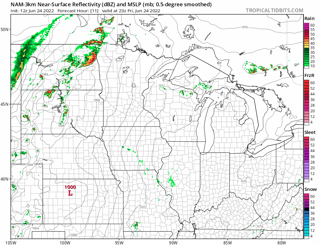
The National Oceanic and Atmospheric Administration’s North American Mesoscale (NAM) forecast model shows the potential rain pattern from 6 p.m. Friday to 6 p.m. Saturday:
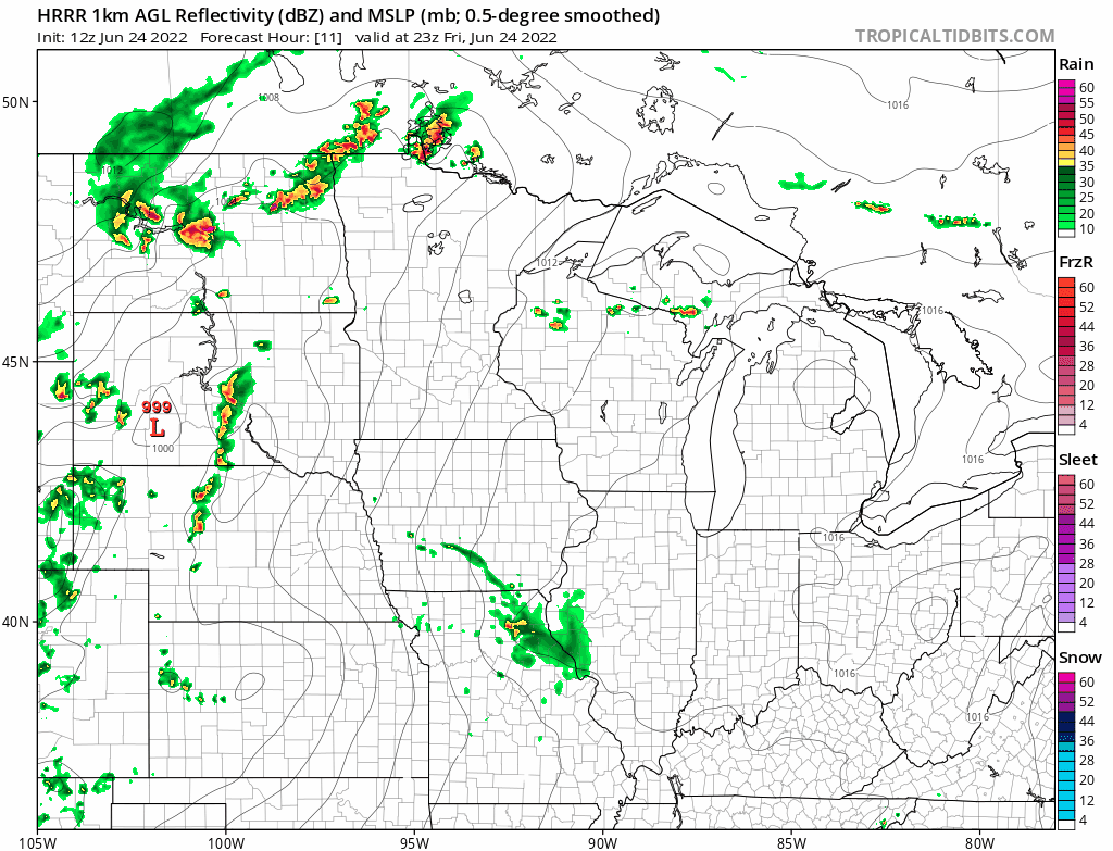
NOAA’s High-Resolution Rapid Refresh forecast model shows the following rain pattern for Friday evening through Saturday afternoon:
Severe weather potential
The NWS Storm Prediction Center shows an enhanced risk of severe weather Friday afternoon through Friday night (which ends at 7 a.m. Saturday) in northwestern and west-central Minnesota, with a slight risk (shaded yellow) of severe weather from north-central through southwestern Minnesota:

Enhanced risk means that numerous severe thunderstorms are possible, slight risk means that scattered severe thunderstorms are possible:

Most of the Twin Cities metro area is in the Storm Prediction Center’s marginal risk category Friday night into early Saturday, which means that an isolated severe thunderstorm is possible..
You can hear updated weather information for Minnesota and western Wisconsin on the Minnesota Public Radio News network, and you can see updated weather info on the MPR News live weather blog.
——————————————————————————————-
Mid-afternoon update
The NWS Storm Prediction Center has issued a severe thunderstorm watch valid until 9 p.m. this Friday for portions of North Dakota and northwestern Minnesota:
Portions of Morrison, Stearns and Benton county had 6 to 12 inches of rain Thursday night into early Friday.
The National Weather Service has issued a flood watch for several counties in central Minnesota from 10 p.m. this Friday to 8 a.m. Saturday:

Here are details of the flood watch:
Flood Watch National Weather Service Twin Cities/Chanhassen MN 219 PM CDT Fri Jun 24 2022 MNZ042>045-049>052-250515- /O.NEW.KMPX.FA.A.0002.220625T0300Z-220625T1300Z/ /00000.0.ER.000000T0000Z.000000T0000Z.000000T0000Z.OO/ Todd-Morrison-Mille Lacs-Kanabec-Stearns-Benton-Sherburne-Isanti- Including the cities of St Cloud, Cambridge, Sauk Rapids, Princeton, Little Falls, Long Prairie, Mora, and Elk River 219 PM CDT Fri Jun 24 2022 ...FLOOD WATCH IN EFFECT FROM 10 PM CDT THIS EVENING THROUGH SATURDAY MORNING... * WHAT...Flash flooding caused by excessive rainfall is possible. * WHERE...Portions of central Minnesota and east central Minnesota, including the following counties, in central Minnesota, Benton, Morrison, Sherburne, Stearns and Todd. In east central Minnesota, Isanti, Kanabec and Mille Lacs. * WHEN...From 10 PM CDT this evening through Saturday morning. * IMPACTS...Area creeks and streams are running high and could flood with more heavy rain. * ADDITIONAL DETAILS... - Rounds of heavy rainfall could produce totals of 1 to 2 inches, leading to the possibility of flash flooding. - http://www.weather.gov/safety/flood PRECAUTIONARY/PREPAREDNESS ACTIONS... You should monitor later forecasts and be prepared to take action should Flash Flood Warnings be issued.
___________________________________________________________________________________
Cooler temps
After our recent hot weather, you may be ready for some cooler temps.
Saturday highs will be in the lower 80s from the Twin Cities into southeastern Minnesota and western Wisconsin, with mainly 70s elsewhere:

Saturday afternoon dew points will be in the 50s to the northwest, with sticky 60s lingering in the southeast:

Sunday highs will be in the 60s in northern Minnesota, with 70s in central and southern Minnesota and much of western Wisconsin:

Sunday afternoon dew points will be in the comfortable 40s:

Programming note
You can hear my live weather updates on MPR News at 7:35 a.m., 9:35 a.m. and 4:39 p.m. each Saturday and Sunday.