Bright and beautiful Sunday; lots of 70s on Monday
Fall color update for leaf-peepers
Nice recovery!
After a Saturday morning low of 38 degrees at Minneapolis-St. Paul International Airport, the afternoon high temp was 64 degrees. That high was 6 degrees warmer than our average Oct. 16 high in the Twin Cities.
Many locations in Minneapolis and St. Paul will see lows around 40 degrees by early Sunday morning, with mainly 30s elsewhere in the metro area. Sunday morning lows will be in the 30s across most of Minnesota and western Wisconsin.
Temperature trends
Create a More Connected Minnesota
MPR News is your trusted resource for the news you need. With your support, MPR News brings accessible, courageous journalism and authentic conversation to everyone - free of paywalls and barriers. Your gift makes a difference.
Sunday highs reach the 60s in most areas, with a few lower 70s in southwestern Minnesota:

A few spots in the metro area could creep into the upper 60s.
Southerly winds pick up a bit on Monday, allowing many areas to reach the 70s:

Twin Cities metro area highs are projected to reach the lower 70s on Monday and around 70 on Tuesday, followed by mid 60s Wednesday. Cooler temps will be with us to end the week, with highs in the lower 50s Thursday and mid 50s Friday.
Next Saturday could feature near-normal temps, with temps edging upward a bit on Sunday. The following week may be warmer than normal. The NWS Climate Prediction Center shows a tendency for above-normal temps in Minnesota and western Wisconsin from Oct. 24 through Oct. 30:

Next rain chance?
A low pressure system will give us a chance of showers in Minnesota and western Wisconsin Wednesday and Wednesday night.
NOAA’s Global Forecast System (GFS) model shows the potential rain pattern Wednesday and Wednesday night:

You can hear updated weather information for Minnesota and western Wisconsin on the Minnesota Public Radio News network, and you can see updated weather info on the MPR News live weather blog.
Fall colors
The latest fall color report from the Minnesota Department of Natural Resources shows colors past peak in the dark-red shaded areas of northern and central Minnesota:
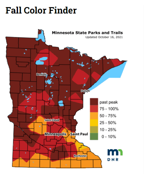
The percentage of changeover to fall colors is between 75% and 100% in the medium-red shaded areas, including parts of the west metro.
Keep in mind that all deciduous trees are included in the fall color report, not just maples.
Wisconsin fall color info can be found here.
Weather nugget
Meteorological autumn 2021, which began on Sept 1, hasn’t yet delivered a reading of 32 degrees or colder at MSP airport.
Twin Cities weather records reveal that the earliest 32 degree or colder reading of meteorological autumn was on Sept. 3, 1974. The deepest into autumn that we’ve gone for our first 32 degree or colder reading in the Twin Cities was Nov. 18, 2016.
Programming note
You can hear my live weather updates on MPR News at 7:35 a.m., 9:35 a.m. and 4:39 p.m. each Saturday and Sunday.