Mild and mostly sunny for the weekend
Warm temperatures continue through next week
Rain moves through Minnesota Friday, but it clears quickly setting the stage for sunshine and seasonable warmth for the first weekend of autumn.
Friday’s forecast
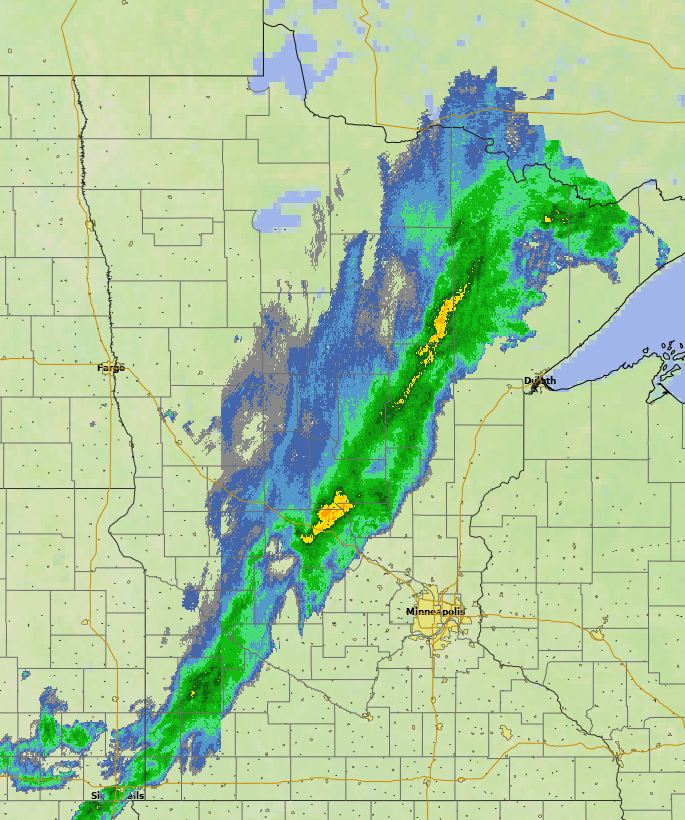
Minnesota started Friday with a cold front carving its way across the state, headed southeast. It passed through central Minnesota by 9 a.m., bringing a broad swath of predominantly light to moderate showers along with it, although there are a couple spots of heavier rain (shown in yellow).
It continues southeast through the day, finally clearing through the state by evening. There could be a few isolated thunderstorms with the rain, but rain showers are the primary weather, and no severe weather is expected.
Precipitation totals will be light with most places, including the Twin Cities, expected to see under one-quarter inch of rainfall. For the Twin Cities, the most likely timing is right around the lunch hour, from late morning to early afternoon.
Create a More Connected Minnesota
MPR News is your trusted resource for the news you need. With your support, MPR News brings accessible, courageous journalism and authentic conversation to everyone - free of paywalls and barriers. Your gift makes a difference.
Because much of the state either saw extra cloud cover overnight as the front moved in, or stayed ahead of the front in a southerly wind flow, morning temperatures were a couple of degrees above average in most spots, mostly in the 40s and 50s.
However, because of the clouds and limited sunshine, plus cooler air coming in behind the front, warming is limited Friday. Much of Minnesota will be stuck in the lower 60s for highs.

A pleasant first weekend of fall
Behind Friday’s cold front, skies clear quickly for most of the state. A few more clouds and a couple of isolated showers may linger along the northern edge of Minnesota into Saturday, but otherwise there will be plenty of sunshine over the weekend.
There will still be a little cooler air lingering Saturday, keeping highs in the 60s with low 70s west. The combination of sunshine and the return of southerly winds put most of Minnesota back into the 70s Saturday, which is slightly above average.
Extended forecast
Pleasant fall weather should continue for much of next week, with mostly sunny skies and highs predominantly in the 70s.
Here is that Twin Cities temperature forecast through Tuesday:

By the middle of next week, a few low 80s are possible in southern or western Minnesota. The mild weather is expected to continue most of next week and through the first weekend of October.

Meanwhile, drier weather prevails, with plenty of sunshine most of next week. It currently looks like the next chance for rain may come Thursday and Friday.

We will continue to monitor that chance and keep you posted as anything approaches.
Enjoy the first weekend of autumn!
Programming note
You can hear my live weather updates on Minnesota Public Radio at 7:48 a.m. Monday through Friday morning.