Severe weather risk Thursday; warm, sunny weekend ahead
Friday will be cooler before warm air and sunshine return
A cold front moving across Minnesota is bringing needed rain and a concern for severe weather. The colder air behind the system only lasts briefly.
Thursday’s forecast
Minnesota is under the influence of a warm front Thursday morning ahead of a storm system moving into the state.

This kept temperatures mild overnight. Morning temperatures were in the 50s and 60s.
The current southerly wind flow is also gusty. Southern Minnesota can expect gusts of more than 30 mph, possibly reaching 40 mph during the day.
Create a More Connected Minnesota
MPR News is your trusted resource for the news you need. With your support, MPR News brings accessible, courageous journalism and authentic conversation to everyone - free of paywalls and barriers. Your gift makes a difference.
However, the cold front with the storm was already pushing into northwestern Minnesota as of 9 a.m. Thursday. It will move slowly across the state throughout the day, clearing out of the southeastern corner of the state Friday morning.
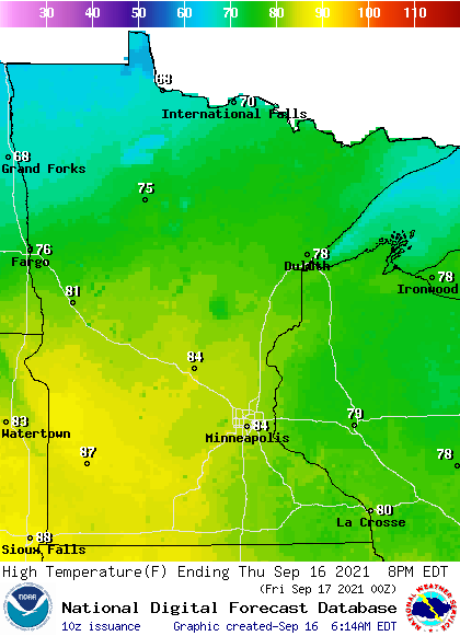
This means southern Minnesota will be in the warm sector most of the day, while northern Minnesota starts to feel the influence of cooler air.
Because of this, highs Thursday will range from 60s northwest to 80s south.
The storm system already pushed a few showers and storms through Minnesota overnight and early Thursday, and spotty activity is possible anytime during the day.
But the main area of showers and storms is associated with the cold front, and as it passes through central Minnesota, severe weather is a concern.

High winds and damaging hail are the primary risk, but isolated tornadoes are also possible.
For the Twin Cities, there is an isolated severe weather risk. The timing of storms is most likely in the late evening and overnight.
Southern Minnesota is forecast to see the heavier precipitation with this storm, with some widespread totals over 1 inch expected.

Extended Forecast
The last of the rain from the storm should clear the southeastern edge of Minnesota by Friday morning. Skies clear quickly with sunshine returning across the state by the afternoon.
Despite the sunshine, cool air behind the cold front will drop temperatures noticeably from Thursday, with most of the state stuck in the 60s. Southern Minnesota may see a few low 70s in the afternoon, but the highs there are likely to come at midnight, when the warmer air of Thursday is still in place.
Temperatures rebound quickly, with highs back in the 70s Saturday under continued sunshine.

More sun plus southerly winds push almost the entire state back above average and into the 80s by Sunday, and Monday also stays warm.
Here is that temperature forecast for the Twin Cities (Friday’s high is likely to be at midnight, with daytime highs only near 70):
Another storm targeting Minnesota Monday and Tuesday is expected to drop temperatures again by the middle of next week.

Programming note
You can hear my live weather updates on Minnesota Public Radio at 7:48 a.m. Monday through Friday morning.