Severe weather risk Thursday; sunshine for the weekend
A weather system affects Minnesota beginning late Wednesday, bringing storms and sending temperatures on a roller-coaster ride.
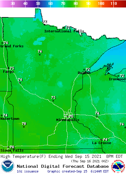
Wednesday’s forecast
Under clear skies overnight, Wednesday started off cool, with slightly below-average temperatures. Most of the state had lows in the 40s, with a few 30s north and a couple of low 50s lingering near the Twin Cities.
Along with the mostly clear skies, morning winds were fairly light, which lead to areas of fog in central and southern Minnesota that have since lifted.
Neither the light winds or clear skies last through the day.
Create a More Connected Minnesota
MPR News is your trusted resource for the news you need. With your support, MPR News brings accessible, courageous journalism and authentic conversation to everyone - free of paywalls and barriers. Your gift makes a difference.
After a mostly sunny morning, clouds increase during the afternoon and evening ahead of a storm system affecting Minnesota Thursday.
That system starts bringing a few showers and storms into northern Minnesota by Wednesday evening. It also increases winds, making it breezier in western Minnesota, and brings in a southerly flow.
Those southerly winds, along with the sunshine during the first half of the day, put most of Minnesota back in the mid-70s Wednesday.
Extended forecast
The precipitation that starts moving in Wednesday spreads across the state by Thursday and is likely to linger in southern Minnesota Friday.

This is all part of a storm that initially brings warmer air in before sweeping a cold front across the state.
Most of the state will see at least some rain, with southern Minnesota mostly likely to see rainfall totals over one-half inch.
There is a risk for severe weather Thursday as the cold front moves through Minnesota.

Large hail and damaging winds are the primary threat, but isolated tornadoes are possible.
On Thursday, in the warm air ahead of the storm, southern Minnesota will make it into the 80s, with 70s north. By Friday, the entire state turns cooler behind the cold front, with highs only in the 60s and low 70s.
Here is the forecast for the Twin Cities showing the temperature change:

Widespread sunshine returns Saturday, putting most of Minnesota back in the 70s. That sunshine plus southerly winds push almost all of the state back above average and into the 80s by Sunday.
Warmer than average temperatures are forecast to continue for at least the first half of next week.
Programming note
You can hear my live weather updates on Minnesota Public Radio at 7:48 a.m. Monday through Friday morning.