Summerlike Friday, cooler weekend; comfy temps next week
Minnesota drought improves but problems persist
The work week will wind down with a beautiful, summerlike Friday. Smoke from western wildfires will drift in from the Dakotas but should remain aloft and just give us a hazy sky by late in the day.
High temperatures will be in the mid to upper 70s in the northeast and low to mid 80s elsewhere across the state. The Twin Cities should have a high around 81 with a south breeze of 10 to 15 mph.
Transition Saturday
A weak cold front will bring cooler temperatures to northern Minnesota on Saturday.

Highs will be in the mid 60s to low 70s up north while toasty 80s linger across southern Minnesota. The Twin Cities should reach about 82 degrees just ahead of the front.
Create a More Connected Minnesota
MPR News is your trusted resource for the news you need. With your support, MPR News brings accessible, courageous journalism and authentic conversation to everyone - free of paywalls and barriers. Your gift makes a difference.
Turning seasonably cooler
Cooler weather with seasonable temperatures will spread across all of Minnesota from Sunday through about Wednesday. The Twin Cities should have comfy highs in the low to mid 70s on those days before warming temporarily on Thursday.

Chances of rain?
This weekend will remain dry for most of us. But there will be a chance of scattered thunderstorms in far northeastern Minnesota along the Canadian border Friday night. Scattered showers are possible across southern Minnesota Saturday night into Sunday.
A better chance of more widespread rain seems likely Monday and Tuesday, especially across extremely dry northern Minnesota.
The heavy rains shown over the western Gulf of Mexico and spreading into Texas and Louisiana are courtesy of a tropical disturbance currently over Central America. They’re forecast to intensify over the warm Gulf waters.

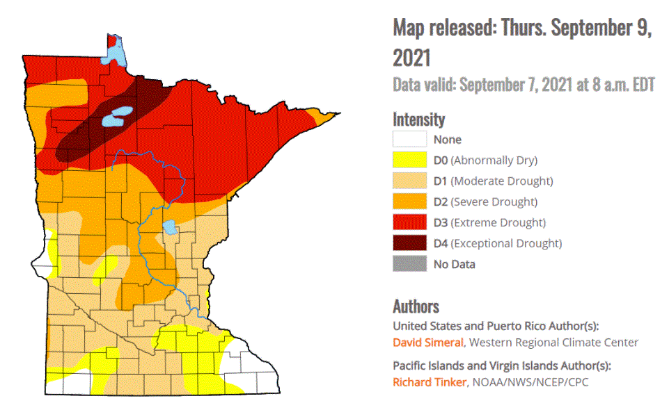
Minnesota drought improves but problems persist
The U.S. Drought Monitor released on Thursday shows that Minnesota’s drought condition remains serious. Here are the key points from the latest report:
While recent rains have improved moisture conditions in parts of central and southern Minnesota slightly, approximately 85 percent of the state remains in moderate or worse drought
All of northern Minnesota remains in moderate to severe drought
An area of extreme drought, the worst category, persists in northwestern Minnesota from International Falls through the Red Lakes area to northeast of Fargo-Moorhead
For a more-complete wrap-up of current Minnesota drought conditions and changes, as well as changes to stream and river flows, check out Paul Huttner’s excellent Updraft posted Thursday.