Air quality alert for Minnesota; Weekend forecast: Comfy, chance of a Sat. shower
Sunday the coolest day this weekend
Smoke from Canadian wildfires was very dense on Thursday. I could barely see the Minneapolis skyline Thursday afternoon:

The IDS Center is slightly to the right of center in the pic.
The smoke isn’t quite as thick today, but it is still of concern. The Minnesota Pollution Control Agency continues an air quality alert until 3 p.m. Friday afternoon for all of Minnesota, except for Lake and Cook counties of northeastern Minnesota. The MPCA has indicated that an air quality alert may be needed for portions of the weekend. An air advisory continues until 8 p.m. this Friday in western Wisconsin.
You can check the latest Minnesota air quality reports here. This was the air quality situation at noon today, with the Twin Cities and much of western Minnesota in the unhealthy category:
Create a More Connected Minnesota
MPR News is your trusted resource for the news you need. With your support, MPR News brings accessible, courageous journalism and authentic conversation to everyone - free of paywalls and barriers. Your gift makes a difference.

Very unhealthy air quality conditions lingered in parts of northwestern Minnesota
Here’s more info on the color codes that are used for air quality:

Weekend temps
Our average Twin Cities high temperature is 83 degrees on July 31. Highs in the mid 80s are expected in the metro area Saturday, and most of Minnesota and western Wisconsin will reach the 80s:

Far northern Minnesota will top out in the 70s.
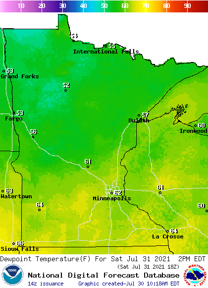
Saturday dew points will be in the comfortable 50s in most spots, with 60s in the far south:
Sunday highs will be in the 70s in many areas, with some lower 80s in the far south:

Sunday dew points will be very comfortable; in the 40s and lower 50s:

Spotty Saturday showers?
Minnesota and western Wisconsin could see a few very spotty showers, and possibly an isolated thunderstorm, on Saturday.
The National Oceanic and Atmospheric Administration’s High-Resolution Rapid-Refresh (HRRR) forecast model shows the potential rain pattern from Saturday morning through Saturday evening:

NOAA’s North American Mesoscale (NAM) forecast model also shows the spotty rain potential on Saturday

You can hear updated weather information for Minnesota and western Wisconsin on the Minnesota Public Radio network, and you can see updated weather info on the MPR News live weather blog.
Sunday still looks dry.
Programming note
You can hear my live weather updates on MPR News at 7:35 a.m., 9:35 a.m. and 4:39 p.m. each Saturday and Sunday.