Periods of rain and thunder this Father's Day
Many areas will see over one-half inch of rain
I know, the timing is unfortunate….our first widespread rain in weeks will happen on Father’s Day. Periods of rain are expected in Minnesota and western Wisconsin this Sunday and Sunday evening, with some embedded thunderstorms at times.
The National Oceanic and Atmospheric Administration’s North American Mesoscale (NAM) forecast model shows the potential rain pattern Sunday and Sunday evening:

NOAA’s High Resolution Rapid-Refresh (HRRR) model shows a similar rain pattern, with slightly different timing:

This will be the most widespread rain that we have seen in a while. Many locations could pick up one-half inch or more of rain:
Create a More Connected Minnesota
MPR News is your trusted resource for the news you need. With your support, MPR News brings accessible, courageous journalism and authentic conversation to everyone - free of paywalls and barriers. Your gift makes a difference.

You can hear updated weather information for Minnesota and western Wisconsin on the Minnesota Public Radio network, and you can see updated weather info on the MPR News live weather blog.
Severe weather outlook
A few strong or severe thunderstorms are possible this Sunday and Sunday evening. The National Weather Service Storm Prediction Center shows a marginal risk of severe weather in portions of southern Minnesota, the Twin Cities metro area, and west-central and southwestern Wisconsin Sunday and Sunday night.
The marginal risk area is shaded dark-green on the NWS graphic below:

Marginal risk means that an isolated severe thunderstorm is possible. Iowa plus a sliver of far southern Minnesota have a bit higher chance of severe weather Sunday/Sunday evening; scattered severe thunderstorms are possible in the yellow-shaded area of the graphic. The severe weather outlook is updated several times each day by the Storm Prediction Center.
______________________________________________________________________________________________
8:20 a.m. Update
The NWS Storm Prediction Center has updated the Sunday/Sunday night severe weather outlook and expanded the slight risk (yellow-shaded) area to include much of southeastern Minnesota and parts of southwestern Wisconsin:
Slight risk means that scattered severe thunderstorms are possible. The dark-green shaded area (which includes the Twin Cities metro) defines the marginal risk of severe weather today and tonight; meaning that an isolated severe t-storm is possible.
_______________________________________________________________________________________________
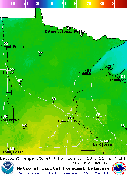
Sunday temps and dew points
Sunday highs will be mainly in the 60s to the north, with 70s in southern Minnesota:

Sunday afternoon dew points will be in the sticky 60s from the southern half of Minnesota into western Wisconsin:
Programming note
You can hear my live weather updates on MPR News at 7:35 a.m., 9:35 a.m. and 4:39 p.m. each Saturday and Sunday.