Sunday heat recap; temps retreat a bit on Monday
Thursday is our best rain opportunity
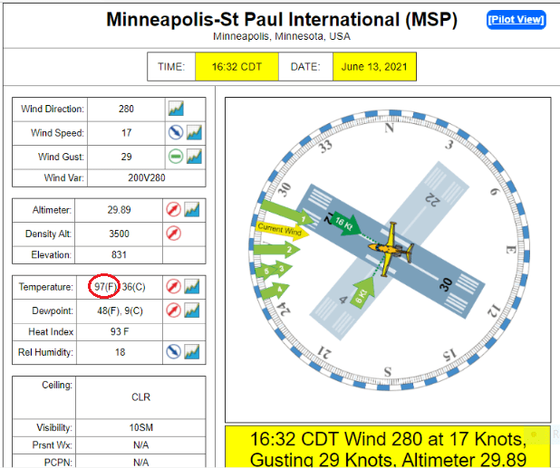
The Twin Cities metro area had highs in the 90s last Sunday, and we did it again this Sunday, hitting 97 degrees at 4:32 p.m.:
Sunday highs reached the 90s across most of southern and central Minnesota.
90+ temps in June
Sunday was our 10th day this June with a high of 90 degrees or warmer in the Twin Cities. A check of Twin Cities weather records revealed just six other Junes with 10 or more days of 90 degrees or warmer:
Create a More Connected Minnesota
MPR News is your trusted resource for the news you need. With your support, MPR News brings accessible, courageous journalism and authentic conversation to everyone - free of paywalls and barriers. Your gift makes a difference.

The highest June total was 17 days of 90 or warmer, in 1933.
Temperature trends
Our average Twin Cities high temperature is 79 degrees this time of year. We’re looking at metro area highs in the upper 80s on Monday.
Most of Minnesota and western Wisconsin will see Monday highs in the 80s:

There’ll be some 70s in far northern Minnesota.
Monday afternoon dew points will be in the comfortable 40s in most areas:

Back to high temperatures, Twin Cities metro area highs are projected to reach the mid 80s Tuesday, followed by upper 80s Wednesday and lower 90s on Thursday. Temps retreat a bit on Friday, with highs in the mid 80s. An early look at next weekend points to highs in the lower 80s.
How about beyond next weekend? Temperatures the following week could average out near normal. The NWS Climate Prediction Center isn’t showing a tendency for above-normal or below-normal temps in Minnesota or Wisconsin from June 21 through June 27:

Any rain chances?
There is a chance of scattered showers and thunderstorms Sunday evening for parts of northeastern Minnesota and northern Wisconsin. There could also be a isolated shower or thunderstorm in far southwestern Minnesota. You can hear updated weather information for Minnesota and western Wisconsin on the Minnesota Public Radio network, and you can see updated weather info on the MPR News live weather blog.
Most parts of Minnesota are either abnormally dry or in drought right now. Our best chance of meaningful rain this week will be on Thursday. NOAA’s Global Forecast System (GFS) model may be overdoing the rain coverage a bit for Thursday, but it does show some areas of rain developing from Wednesday evening into Thursday evening:

Check forecast updates this week to see how our Thursday rain chances are evolving.
Programming note
You can hear my live weather updates on MPR News at 7:35 a.m., 9:35 a.m. and 4:39 p.m. each Saturday and Sunday.