A warm Saturday, hot on Sunday; not very humid
A look at the incredible 1936 heat wave
I’ll start with a recap of our June heat wave.
The temperature at Minneapolis-St. Paul International Airport topped out at 90 degrees Friday afternoon. Friday was our ninth consecutive day with a high temp of 90 or higher in the Twin Cities. That’s tied for the third-longest streak of 90 degrees or warmer in Twin Cities weather records, which date back to 1872. The last time that the Twin Cities saw 9 consecutive days with highs of 90 or warmer was in July of 2006.
The record heat wave of 1936
The longest stretch of days with highs of 90 or warmer in Twin Cities weather records is 14 days; from July 5 through July 18 of 1936. The Twin Cities high temp was 100 degrees or warmer on 8 of those 14 days. Here’s a look at those highs of 100 or higher in July of 1936, which included a stretch of five consecutive days:
Create a More Connected Minnesota
MPR News is your trusted resource for the news you need. With your support, MPR News brings accessible, courageous journalism and authentic conversation to everyone - free of paywalls and barriers. Your gift makes a difference.

A summery Saturday
Saturday highs are expected to be in the 80s across most of Minnesota and western Wisconsin, with a few 70s in north-central and northeastern Minnesota. Many spots in the Twin Cities metro area will reach the upper 80s. Dew point temps will be in the comfortable 40s to lower 50s. It’ll be a bit breezy, with the highest wind gusts in far northern Minnesota.
Hot on Sunday
Highs in the 90s return to much of Minnesota and western Wisconsin on Sunday:

Far northern Minnesota will have Sunday highs in the 80s.
Sunday dew points will be mainly in the lower 50s:

Sunday afternoon wind gusts of 16-22 mph are expected in many areas:
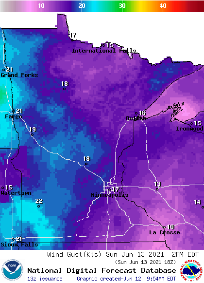
Forecast gusts are in knots, with 17 knots equal to 19.6 mph. Gusts could approach 25 mph at times in western Minnesota.
Sunday rain chances?
A few scattered showers and thunderstorms are possible in roughly the northern third of Minnesota and parts of northwestern Wisconsin Sunday and Sunday evening. The National Oceanic and Atmospheric Administration’s North American Mesoscale (NAM) forecast model shows the potential rain pattern for Sunday and Sunday evening:

You can hear updated weather information for Minnesota and western Wisconsin on the Minnesota Public Radio network, and you can see updated weather info on the MPR News live weather blog.
Temperature trends
Twin Cities metro area highs are projected to reach the upper 80s Monday, followed by mid 80s on Tuesday. We could hit 90 on Wednesday and lower 90s on Thursday, followed by lower 80s Friday.
Programming note
You can hear my live weather updates on MPR News at 7:35 a.m., 9:35 a.m. and 4:39 p.m. each Saturday and Sunday.