Cold front brings some relief to Minnesota's hot and humid trend
As the humidity drops, fire concerns increase again

A cold front moving across the state Friday will finally bring a slight break in the recent heat wave that has gripped Minnesota. Meanwhile, rain prospects stay slim as drought conditions increase across the state.
The heat wave that started last week has set records around the state, and likely brings 90s again to the Twin Cities, even while many places start seeing slightly cooler weather.
Another 90 or above day will put the Twin Cities region in a tie with six other years for the third longest stretch of 90s ever on record at nine days straight. It will also be the earliest ever in a season for such a long heat wave.

The graphic above also highlights record highs and record warmest lows (in red), and another noteworthy aspect of the heat is that almost every morning of the heatwave set records.
Even Friday will likely end up setting another record as the morning temperature for the Twin Cities was 76, and we are unlikely to drop below the current record of 74 before midnight.
Create a More Connected Minnesota
MPR News is your trusted resource for the news you need. With your support, MPR News brings accessible, courageous journalism and authentic conversation to everyone - free of paywalls and barriers. Your gift makes a difference.
Friday’s forecast
Minnesota had its final warm and muggy morning of this current heat wave, with high humidity and morning lows predominantly in the 60s and 70s.
A storm system and associated cold front is making its way west to east across the state, bringing showers and storms along with it. As of 10 a.m., the associated line of storms was in western Minnesota, where a few spots saw over an inch of needed rain.

The line is breaking up as it heads east, making severe weather chances fairly remote. However, there are some strong wind gusts up to 40 mph coming out of some thunderstorms.
By the time the activity reaches eastern Minnesota, any showers and thunderstorms become far more isolated, and those parts of the state will mostly see under one-tenth of an inch of rain.
The front going through also causes a large temperature contrast throughout the state by the afternoon. The North Shore will be the chilly spot, with winds off Lake Superior keeping highs near 60.
Where the front goes through earlier, in northern and western Minnesota, the recent heat breaks, with 70s and 80s expected.
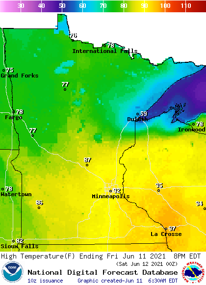
Southeastern Minnesota does not see the front clear through until the evening, making Friday another hot, humid day with some lingering 90s.
Less humid but still hot
Already by Saturday morning, all of Minnesota is behind the cold front and the different air mass will be noticeable in the morning temperatures. The recent humid mornings of 60s and 70s will be replaced by most of the state in the 50s, with a few lingering 60s southeast.

Humidity also drops significantly, with dew points only in the 40s by the afternoon, which means very dry air.
Highs Saturday will be mostly in the 80s, which is still above average for mid-June, but between the slight drop in the heat and lower humidity, it will feel noticeably different.
Hotter weather returns already by Sunday, with central and southern Minnesota back in the 90s. The week ahead stays above average again with many highs in the 80s and low 90s, but overnight lows should stay relatively cooler, with more 50s and 60s much of the week.
Humidity also stays lower through at least midweek, diminishing the risk of heat-related illness somewhat.
Drought worsens
Unfortunately, while the drop in humidity is beneficial for outdoor activities, it could allow the fire risk to surge. Minnesota was very dry in May and so far in June, and that has dry conditions spreading across the state.
One month ago, most of Minnesota, 63 percent, was not listed in any category on the drought monitor. Now, the entire state is considered at least “abnormally dry.”

The portion of the state in drought conditions has swelled from 16 percent on May 11 to 46 percent currently.
The coming week is currently forecast to provide little relief, with no major storm systems on the horizon. The lower humidity, heat, and already dry conditions are likely to elevate fire concerns again.
Programming note
You can hear my live weather updates on Minnesota Public Radio at 7:49 a.m. Monday through Friday morning.