Heat wave lingers this week
Heat advisory in the Twin Cities metro until 8 p.m. Thursday
Our heat wave will continue for several more days.
The official Sunday afternoon high temp at Minneapolis-St. Paul International Airport was 93 degrees. That was 4 degrees shy of our June 6 record high in the Twin Cities, but it was 17 degrees warmer than our average June 6 high of 76 degrees.
Hot streaks
Sunday was our fourth consecutive day with a high of 90 degrees or warmer in the Twin Cities. The Minnesota State Climatology Office looked at warm weather streaks prior to June 15 in the Twin Cities and found that our longest such streak was six days:
Create a More Connected Minnesota
MPR News is your trusted resource for the news you need. With your support, MPR News brings accessible, courageous journalism and authentic conversation to everyone - free of paywalls and barriers. Your gift makes a difference.

Forecast maps show that our current streak of highs of 90 or warmer will continue for several more days.
Heat advisory
The National Weather Service has extended the heat advisory for the Twin Cities metro area through much of this week, continuing the advisory until 8 p.m. this Thursday:

Here are details of the heat advisory:
URGENT - WEATHER MESSAGE National Weather Service Twin Cities/Chanhassen MN 135 PM CDT Sun Jun 6 2021 MNZ060>063-068>070-071000- /O.EXT.KMPX.HT.Y.0001.000000T0000Z-210611T0100Z/ Hennepin-Anoka-Ramsey-Washington-Carver-Scott-Dakota- Including the cities of Minneapolis, Blaine, St Paul, Stillwater, Chanhassen, Chaska, Victoria, Shakopee, and Hastings 135 PM CDT Sun Jun 6 2021 ...HEAT ADVISORY NOW IN EFFECT UNTIL 8 PM CDT THURSDAY... * WHAT...High temperatures in the 90s each day, with overnight lows in the middle 70s. Heat indices in the middle to upper 90s each afternoon. * WHERE...Scott, Carver, Washington, Ramsey, Anoka, Hennepin and Dakota Counties. * WHEN...Until 8 PM CDT Thursday. * IMPACTS...Hot temperatures and increasing humidity may cause heat illnesses to occur. PRECAUTIONARY/PREPAREDNESS ACTIONS... Drink plenty of fluids, stay in an air-conditioned room, stay out of the sun, and check up on relatives and neighbors. Young children and pets should never be left unattended in vehicles under any circumstances. Take extra precautions if you work or spend time outside. When possible reschedule strenuous activities to early morning or evening. Know the signs and symptoms of heat exhaustion and heat stroke. Wear lightweight and loose fitting clothing when possible. To reduce risk during outdoor work, the Occupational Safety and Health Administration recommends scheduling frequent rest breaks in shaded or air conditioned environments. Anyone overcome by heat should be moved to a cool and shaded location. Heat stroke is an emergency! Call 9 1 1.
Temperature trends
Monday highs will reach the 90s across most of central and southern Minnesota plus western Wisconsin:
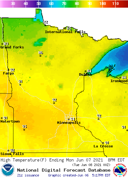
Highs will be in the 80s in portions of northern Minnesota.
Monday afternoon dew points will range from the sticky 60s in southern and central Minnesota to comfortable 40s in portions of northern Minnesota:

Back to high temps, Twin Cities metro area highs are projected to reach the lower 90s Tuesday, followed by mid 90s Wednesday and Thursday, then around 90 on Friday. It looks like we could have highs in the upper 80s next weekend in the metro area. Above-normal highs could linger into the following week. The NWS Climate Prediction Center shows a strong tendency for above-normal temps in Minnesota and Wisconsin from June 14 through June 20:

Thunderstorm chances
If scattered thunderstorms develop in Minnesota and western Wisconsin Sunday evening or overnight Sunday night, an isolated severe thunderstorm will be possible. The area shaded dark green in the following map indicates the area with a marginal risk of severe weather Sunday evening and Sunday night:

The NWS Storm Prediction Center updates the severe weather outlook every few hours.
You can hear updated weather information for Minnesota and western Wisconsin on the Minnesota Public Radio network, and you can see updated weather info on the MPR News live weather blog.
Roughly the northwestern half of Minnesota will have a chance of scattered showers and thunderstorms on Monday, with the best thunder chance during the late afternoon and early evening hours. Check forecast updates.
Programming note
You can hear my live weather updates on MPR News at 7:35 a.m., 9:35 a.m. and 4:39 p.m. each Saturday and Sunday.