Heat wave will continue this week
Heat advisory until Tuesday evening for the metro area
Our June heat wave will continue for several more days.
The National Weather Service has this definition of heat wave:
A heat wave is a period of abnormally hot weather generally lasting more than two days. Heat waves can occur with or without high humidity. They have potential to cover a large area, exposing a high number of people to hazardous heat.
Our average Twin Cities high temperature is 76 degrees his time of year. The official Twin Cities high temp was 99 degrees on Saturday, and a few spots in the metro area reached 100 degrees or higher. We’re expecting Sunday highs in the mid 90s across much of the metro area.
A heat advisory continues in the Twin Cities metro area from today into Tuesday evening:
Create a More Connected Minnesota
MPR News is your trusted resource for the news you need. With your support, MPR News brings accessible, courageous journalism and authentic conversation to everyone - free of paywalls and barriers. Your gift makes a difference.
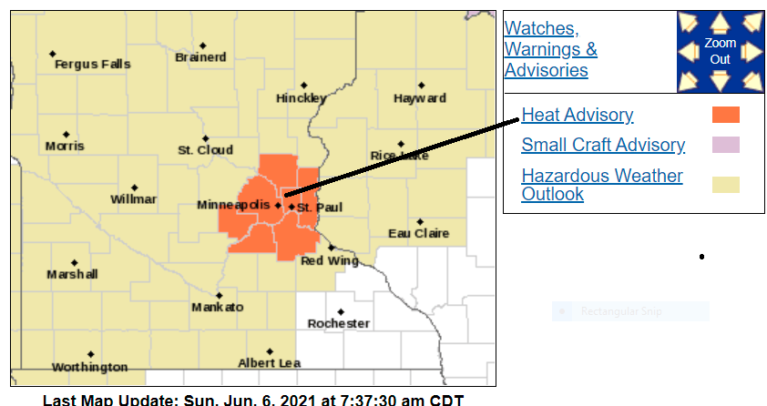
Here are details of the heat advisory:
URGENT - WEATHER MESSAGE National Weather Service Twin Cities/Chanhassen MN 935 AM CDT Sun Jun 6 2021 MNZ060>063-068>070-070615- /O.CON.KMPX.HT.Y.0001.000000T0000Z-210609T0200Z/ Hennepin-Anoka-Ramsey-Washington-Carver-Scott-Dakota- Including the cities of Minneapolis, Blaine, St Paul, Stillwater, Chanhassen, Chaska, Victoria, Shakopee, and Hastings 935 AM CDT Sun Jun 6 2021 ...HEAT ADVISORY REMAINS IN EFFECT UNTIL 9 PM CDT TUESDAY... * WHAT...High temperatures in the mid 90s with overnight low temperatures in the mid 70s. * WHERE...Scott, Carver, Washington, Ramsey, Anoka, Hennepin and Dakota Counties. * WHEN...Until 9 PM CDT Tuesday. * IMPACTS...Hot temperatures may cause heat illnesses to occur. PRECAUTIONARY/PREPAREDNESS ACTIONS... Drink plenty of fluids, stay in an air-conditioned room, stay out of the sun, and check up on relatives and neighbors. Young children and pets should never be left unattended in vehicles under any circumstances. Take extra precautions if you work or spend time outside. When possible reschedule strenuous activities to early morning or evening. Know the signs and symptoms of heat exhaustion and heat stroke. Wear lightweight and loose fitting clothing when possible. To reduce risk during outdoor work, the Occupational Safety and Health Administration recommends scheduling frequent rest breaks in shaded or air conditioned environments. Anyone overcome by heat should be moved to a cool and shaded location. Heat stroke is an emergency! Call 9 1 1.
Highs in the 90s are expected across most of Minnesota and western Wisconsin Sunday afternoon. There’ll be some 80s in northwestern Minnesota and up along the North Shore of Lake Superior.
Thunderstorm chances
Scattered showers and thunderstorms were occurring in parts of northwestern Minnesota Sunday morning. The thunderstorm chances gradually spread to the east and southeast as we go through Sunday afternoon and evening. At this point, it looks like our thunderstorm chance in the Twin Cities will hold off until sometime after 6 p.m. or so.
The NWS Storm Prediction center shows a marginal risk of severe weather this afternoon and tonight in the dark-green shaded area from southwestern Minnesota into northeastern Minnesota:

Marginal risk means that an isolated severe thunderstorm is possible.
Here’s a look at the thunderstorm potential in northeastern Minnesota and northwestern Wisconsin later today:

You can hear updated weather information for Minnesota and western Wisconsin on the Minnesota Public Radio network, and you can see updated weather info on the MPR News live weather blog.
Temperature trends
Monday highs reach the 90s in much of Minnesota and western Wisconsin:

There will be some 80s in the northern third of Minnesota.
Monday dew points will be in the sticky 60s in southern Minnesota, with comfortable 40s in northern Minnesota:

Back to high temps, Twin Cities metro area highs are projected to reach the mid 90s on Tuesday, followed by lower 90s Wednesday, mid 90s Thursday and upper 80s on Friday.
We may see metro highs in the upper 80s next weekend, and above-normal highs could linger into the following week. The NWS Climate Prediction Center shows a strong tendency for above-normal temps in Minnesota and Wisconsin from June 13 through June 19:

Programming note
You can hear my live weather updates on MPR News at 7:35 a.m., 9:35 a.m. and 4:39 p.m. each Saturday and Sunday.