Snow moves in Saturday: Heaviest totals across southern Minnesota
Twin Cities likely sees 3 to 6 inches by Sunday morning

Updated: 5 p.m.
The latest: No significant forecast changes. Here’s the latest Friday afternoon (18Z) NOAA NAM 3 km resolution model snowfall output. Southern Twin Cities could creep into the 6-plus-inch zone.

Our next snowmaker is on the way.
Snow will develop and move across much of Minnesota Saturday. The heaviest snow favors southern Minnesota from south of the Twin Cities to the Iowa border. This snow looks lighter and fluffier than our last system. It will create slick roads and difficult travel late Saturday and Saturday night. But it should be great snow for outdoor activities like sledding and skiing.
Let’s break down the details of the snowfall event.
Create a More Connected Minnesota
MPR News is your trusted resource for the news you need. With your support, MPR News brings accessible, courageous journalism and authentic conversation to everyone - free of paywalls and barriers. Your gift makes a difference.
The system
A moderate strength low-pressure system tracks from Colorado to Kansas Saturday. Southerly flow ahead of the system will throw moisture aloft over the cold air dome sitting over Minnesota. That will generate a large snow shield over most of Minnesota Saturday and Saturday night.
NOAA’s NAM 3 km resolution model brings the bulk of the snow into Minnesota (and the Twin Cities) between 3 p.m. and midnight.

Snowfall timing
Snowfall will develop Saturday morning in southwest Minnesota. Most forecast models bring the leading edge of snow into the Twin Cities from southwest to northeast between about 2 and 4 p.m.

Snowfall intensity will be light Saturday afternoon. Heavier, steadier snow is likely between 6 p.m. and midnight. Snowfall should end in the Twin Cities by 6 a.m. Sunday. It may linger through noon Sunday in southeast and northeast Minnesota.
Snowfall totals
Northwest Minnesota will likely see very little snow with this system. Overall I like the looks of this NAM model forecast snowfall solution.

Here are my snowfall projections for some specific areas.
Most of northern Minnesota will pick up between 1 and 3 inches.
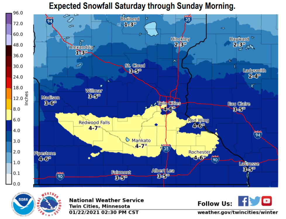
The most likely snowfall range for the greater Twin Cities area is between 3 and 6 inches. The heaviest totals should favor the southern Twin Cities, especially Scott and Dakota counties.
A wide band of 4 to 8 inches is likely across southern Minnesota centered on the Minnesota River Valley. This includes New Ulm, Mankato, Owatonna, toward Rochester.
Here’s the Twin Cities National Weather Service snowfall projection for all of Minnesota.

Here’s a closer look at central and southern Minnesota.
Dry and fluffy
This will be a drier snowfall than our last sloppy system. Models indicate snow to water ratios around 15:1.

That means this snow should be easier to shovel, and better for outdoor winter sports like sledding and skiing.
Bottom line: Expect light snow to spread across Minnesota from southwest to northeast Saturday. Snowfall will be heaviest and steadiest Saturday evening and night. Travel conditions will be challenging from late Saturday afternoon through Saturday night.