A cool and breezy Sunday
It'll feel like September
Our average Twin Cities high temp is 83 degrees this time of year. We’ll probably top out in the low 70s this Sunday afternoon. That would be a typical Twin Cities high in mid September.
Many areas will have highs in the 70s Sunday afternoon:
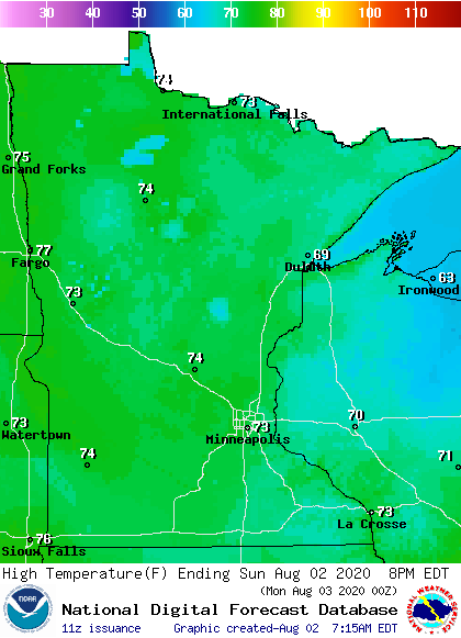
There will be some 60s in parts of northeastern Minnesota and northwestern Wisconsin….with upper 60s possible in parts of west-central Wisconsin.
Sunday afternoon dew points will be in the comfortable 50s, with some very dry 40s in the far north:
Create a More Connected Minnesota
MPR News is your trusted resource for the news you need. With your support, MPR News brings accessible, courageous journalism and authentic conversation to everyone - free of paywalls and barriers. Your gift makes a difference.

Winds could gust to 20 mph at times:

Plotted values are in knots, with 17 knots equal to around 20 mph.
Shower chances
A few scattered sprinkles are possible this Sunday, mainly in southeastern Minnesota and western Wisconsin. A passing sprinkle cannot be ruled out in the Twin Cities metro area as well.
You can hear updated weather information on the MPR network, and you’ll see updated weather info on the MPR News live weather blog.
This Updraft blog will be updated by around 10 a.m. with updated info on your Sunday weather and a look at the week ahead.
Programming note
You can hear my live weather updates on MPR News at 7:35 a.m., 9:35 a.m. and 4:35 p.m. each Saturday and Sunday.